Grounding
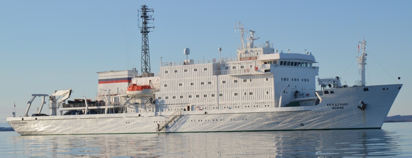
Passenger vessel Akademik Ioffe
Latitude 69°43.043′ N
Longitude 091°20.951′ W
Astronomical Society Islands, Nunavut
The Transportation Safety Board of Canada (TSB) investigated this occurrence for the purpose of advancing transportation safety. It is not the function of the Board to assign fault or determine civil or criminal liability. This report is not created for use in the context of legal, disciplinary or other proceedings. See Ownership and use of content. Masculine pronouns and position titles may be used to signify all genders to comply with the Canadian Transportation Accident Investigation and Safety Board Act (S.C. 1989, c. 3).
Executive summary
On , the passenger vessel Akademik Ioffe ran aground 78 nautical miles north-northwest of Kugaaruk, Nunavut. The Akademik Ioffe was sailing through narrows in a remote area of the Canadian Arctic that was not surveyed to modern or adequate hydrographic standards, and where none of the vessel crew had ever been. The vessel ran aground at a speed of 7.6 knots before the bridge team could take evasive action; team members were not closely monitoring the echo sounders, and the steady decrease of the under-keel water depth went unnoticed for more than 4 minutes, because the echo sounders’ low water depth alarms had been turned off.
In his assessment of the occurrence voyage plan, the master relied on a Canadian chart that contained incomplete bathymetric data.Footnote 1 Because the chart indicated spot soundings that showed localized sufficient water depths, and because the chart did not show any shoals or other navigational hazards, the bridge team of the Akademik Ioffe considered that the narrows were safe to transit, and consequently did not implement any additional precautions. Following the grounding, the Canadian Coast Guard vessels Pierre Radisson and Amundsen were tasked to assist, and 5 aircraft were dispatched by the Canadian Armed Forces. The vessel self-refloated later that night and, on 25 August 2018, its passengers were evacuated and transferred to the sister passenger vessel Akademik Sergey Vavilov. The Akademik Ioffe sustained serious damage to its hull: 2 ballast water tanks and 2 fuel oil bunker tanks were breached and took on water. An estimated 80.51 L of the vessel's fuel oil was released in the environment. No injuries were reported.
The investigation determined that if a vessel’s crew conducts passage planning and assessment based on incomplete and unreliable navigational data, and without taking mitigating measures, there is an increased risk to the safety of the vessel and its complement. Also, if bridge navigation equipment is not optimally operated and automatic safety features such as alarms are turned off, there is a risk that a bridge team will miss critical information, especially in situations where the prevailing navigating conditions create a high workload for bridge team members. Moreover, if the bridge team composition is inadequate during periods of high workload, such as when transiting confined waters, there is a risk that critical navigational parameters, such as the under-keel water depth, will not be properly monitored, compromising vessel safety.
The TSB investigation into this occurrence revealed safety deficiencies that led the Board to issue a safety recommendation.
Risk mitigation measures for vessels transiting Canadian Arctic waters
Transport Canada regulates navigation of domestic and foreign vessels within Canada’s territorial waters, including the coastal waters surrounding the Canadian Arctic Archipelago. Fisheries and Oceans Canada, through the Canadian Hydrographic Service, is responsible for meeting Canada’s international obligation to provide hydrographic services; the Canadian Coast Guard is responsible for the provision of marine search and rescue resources, traffic monitoring, icebreaker assistance and diffusion of navigation safety information, among other services. Both Transport Canada and the Fisheries and Oceans Canada, combined, have the regulatory mandate to implement various risk mitigation measures to reduce the likelihood and consequences of a passenger vessel running aground in Arctic waters.
This investigation determined that voyage planning in the Canadian Arctic has unique risks that require additional mitigation measures in order to ensure the safety of passenger vessels, and to protect the vulnerable Arctic environment. Until the coastal waters surrounding the Canadian Arctic Archipelago are surveyed to modern or adequate hydrographic standards, and if alternate mitigation measures are not put in place, there is a persistent risk that vessels will make unforeseen contact with the sea bottom. The Board therefore recommends that
the Department of Transport, in collaboration with the Department of Fisheries and Oceans, develops and implements mandatory risk mitigation measures for all passenger vessels operating in Canadian Arctic coastal waters.
TSB Recommendation M21-01
1.0 Factual information
1.1 Particulars of the vessel
| Name of the vessel | Akademik Ioffe |
|---|---|
| IMO number / Official number | 8507731 / 870072 |
| Port of registry | Kaliningrad |
| Flag | Russian Federation |
| Type | Passenger |
| Call sign | UAUN |
| Classification | Russian Maritime Register of Shipping - KM(*) L1 [1] A2 passenger ship |
| Gross tonnage | 6450 |
| Length overall | 117.1 m |
| Breadth | 18.2 m |
| Depth to main deck | 10.0 m |
| Maximum loaded draught / deadweight | 5.9 m / 1738 tonnes |
| Draught at time of occurrence | 5.75 m Forward / 5.9 m Aft |
| Built | 1989, Hollming Oy, Rauma, Finland (hull No. 266) |
| Propulsion | 2 medium-speed, 4-stroke diesel engines driving 2 controllable pitch propellers (total maximum continuous rating [MCR] 5152 kW). |
| Bow thruster | 1 tunnel thruster, power 700 kW |
| Stern thruster | 1 azimuthing thruster, power 600 kW |
| Crew / Expedition staff | 37 / 24 |
| Passengers | 102 |
| Registered owner/technical manager | P.P. Shirshov Institute of Oceanology of Russian Academy of Sciences (IO RAS), Moscow, Russian Federation |
| Charterer | One Ocean Expeditions Inc., Edmonton, Alberta, Canada, under a charter contract with Terragelida Ship Management Limited, CyprusFootnote 2 |
1.2 Description of the vessel
The Akademik Ioffe was built as an ice-strengthenedFootnote 3 passenger-carrying research and survey vessel for ocean acoustic science, marine geology, bathymetry, geophysics, physical and chemical oceanography, as well as optical and meteorological research work. The machinery space is located aft and the accommodations extend from amidships to forward (Figure 1).
The vessel is fitted with 2 totally enclosed 66-person motor lifeboats that also serve as rescue boats, 204 lifejackets, 12 lifebuoys, 4 inflatable life rafts, 14 immersion suits, and 170 thermal protective aids. The Akademik Ioffe has a sister vessel, the Akademik Sergey Vavilov, and each vessel is certified to carry a maximum complement of 170 persons.
The vessel is propelled by 2 diesel engines which, via gearboxes and clutches, drive 2 controllable pitch propellers at 220 revolutions per minute and 2 shaft generators. The vessel is equipped with bow and stern thrusters that can be powered using various configurations between the shaft generators and the 2 auxiliary diesel generators.
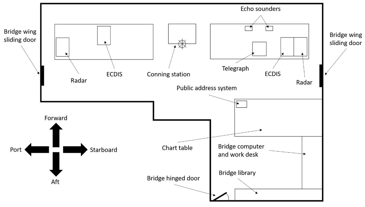
The vessel’s navigation bridge is equipped with 2 class-approved navigation echo soundersFootnote 4 with shallow water, bottom lost, and power failure aural/visual alarms. The echo sounders’ alarms can be manually turned off by the operator. One electronic chart display and information system () is installed on each of the port and starboard bridge consoles. A public address (PA) system is fitted on board and its control panel is located at the aftmost part of the bridge, on a console in front of the chart table (Figure 2).
The vessel’s Global Maritime Distress and Safety System (GMDSS) console is located in a separate radio room, abaft the bridge deck.
The vessel has 16 fuel oil bunker tanks, 13 of which are structural double-bottom tanks. The Akademik Ioffe carries 2 grades of marine fuels in these tanks: marine gas oil (MGO) and intermediate fuel oil (IFO).Footnote 5
For conducting onshore and offshore passenger activities, the vessel carries inflatable personal floatation devices (PFDs), multiple kayaks, and inflatable boats fitted with outboard gasoline motors.
1.3 Time chartering
The Baltic and International Maritime Council (BIMCO) is an international shipping organization based in Denmark, claiming more than 2100 members worldwide, including vessel owners, operators, managers, and maritime brokers and agents. BIMCO defines time chartering as an agreement in which “[t]he shipowners give the time charterers substantial control over the commercial operation of the vessel in exchange for the regular payment of hire.”Footnote 6 In a time charter agreement, the vessel owner operates the vessel and oversees its technical management, while the charterer has control of the vessel’s commercial activities.
At the time of the occurrence, the Akademik Ioffe was chartered by a private Canadian company, One Ocean Expeditions. This particular company specialized in various types of expedition cruises in remote areas worldwide, including the Canadian Arctic. One Ocean Expeditions was a member of the Norway-based Association of Arctic Expedition Cruise Operators, which obligates all members to operate in accordance with national and international maritime laws and regulations.Footnote 7
The vessel owner, the P.P. Shirshov Institute of Oceanology of Russian Academy of Sciences (IO RAS), was responsible for the proper crewing of the vesselFootnote 8 and for managing, maintaining, and providing all applicable insurances.Footnote 9 The owner was also responsible for ensuring the vessel’s seaworthiness and regulatory compliance. One Ocean Expeditions had exclusive control of the vessel’s itineraries, which could vary so long as the itineraries were within the vessel’s capabilities.
The task and the authority to evaluate the vessel’s capabilities rested with the vessel’s master, as he was the individual responsible for the safety of the vessel, its crew, and its passengers.
The International Convention for the Safety of Life at Sea, 1974 (SOLAS) stipulates that
[t]he owner, the charterer, the company operating the ship as defined in regulation IX/1, or any other person shall not prevent or restrict the master of the ship from taking or executing any decision which, in the master’s professional judgement, is necessary for safety of life at sea and protection of the marine environment.Footnote 10
The crew had to provide vessel passengers and expedition staff with all safety drills, including musters at lifeboat stations. During those drills, the crew was responsible for loading and launching the vessel’s lifeboats.
In addition to paying for the vessel’s bunkers, stores, provisions, and port fees, One Ocean Expeditions was also responsible for providing the necessary expedition staff,Footnote 11 who had access to the vessel’s transmission facilitiesFootnote 12 and PA system. One Ocean Expeditions could not require that the vessel be operated in a manner that could endanger the vessel, its crew, or passengers, nor could One Ocean Expeditions breach the vessel’s trading and operational limits.
One Ocean Expeditions offered expedition cruises in the Canadian Arctic on board the Akademik Ioffe at a daily rate of approximately USD 1000 per passenger.
1.4 History of the voyage
On 23 August 2018, the Akademik Ioffe arrived in Pelly Bay and anchored off Kugaaruk, Nunavut, completing an expedition cruise in the Canadian Arctic. As scheduled, all passengers and expedition staff were disembarked and brought ashore by vessel crew using the vessel’s inflatable boats. By 1830,Footnote 13 another group of passengers and expedition staff, which had arrived in Kugaaruk by airplane, had been gradually transferred on board the Akademik Ioffe using the same inflatable boats, during which the passengers were given basic verbal instructions on actions to take should a passenger or boat operator fall overboard. The master and the joining expedition leader conferred; as they both agreed, the master postponed the passengers’ mandatory safety briefing and mustering at the lifeboat stations until the next morning. Following dinner, the ship’s doctor gave the passengers a briefing about seasickness, shipboard hazards, doorways, ladders and staircases, and basic sanitation.
At 2045, the Akademik Ioffe raised its anchor and departed from Kugaaruk on a new expedition cruise to Cambridge Bay, Nunavut, with 102 passengers, 24 expedition staff, and 37 crew members on board. A stopover at the Hecla and Fury Islands was scheduled for the next morning, to allow the passengers an onshore visit.
The morning of 24 August, the expedition leader evaluated the weather conditions forecasted for the Hecla and Fury Islands and surrounding area. Concerned that the prevailing winds and sea conditions (ice, waves) could negatively impact the passengers’ on- and offshore experiences, at 0633, the expedition leader discussed the situation with the master to determine whether to maintain or alter the planned itinerary.
At 0640, the expedition leader changed the voyage’s itinerary, and asked the master to assess the feasibility of diverting the vessel to the Astronomical Society Islands, as this new destination would offer shelter and more comfort for the passengers.
The master assessed the intended passage and concurred with the expedition leader on the feasibility and safety of altering the passage plan. By 0738, a new passage planFootnote 14 had been developed and was sent to the Canadian Coast Guard (CCG) Northern Canada Vessel Traffic Services (NORDREG) for approval; the Akademik Ioffe altered course to 307°G on a northwesterly route toward the Astronomical Society Islands (Appendix A, waypoint E). At 0743, the crew shut down the starboard main engine because the vessel had reached ice-free waters.
At 0801, Transport Canada (TC), via NORDREG, acknowledged the new itinerary and approved the requested deviation (Appendix A, waypoint F). At 0847, following breakfast, the general alarm was sounded to initiate the mandatory mustering and safety briefing for passengers and expedition staff. During this mustering, the passengers were instructed on how to properly don their lifejackets, to dress warmly, and to carry only critical items such as medication with them. The passengers were also shown one of the lifeboats from the outside, while it was in its stowed position (Appendix A, waypoint G). At 1000, the delivery of the first of 2 shore excursion safety briefingsFootnote 15 was initiated by the expedition staff to half of the passengers.Footnote 16
At 1027, the Akademik Ioffe changed course to 221°G to enter the narrows between the Ross Peninsula and the Astronomical Society Islands (Appendix A, waypoint H). As the vessel was making way using its port main engine, a minimal speed of about 8 knotsFootnote 17 was necessary to maintain steerage due to the 20-30 knot winds and a quartering swell. The sea conditions rendered the autopilot ineffective, and so the officer of the watch (OOW) ordered the helmsman to hand steer the vessel.
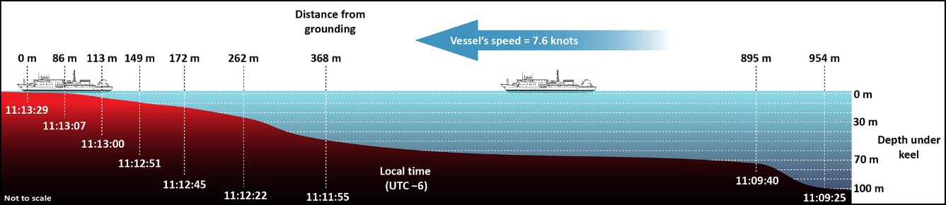
At 1109:25, the water depth under the vessel’s keel was 100 m. At that time, the bridge team consisted of the OOW and the helmsman; the master was at the aft area of the bridge, sitting at the work desk beside the chart table, performing administrative duties. The second engineer was keeping watch in the engine room. The speed was 7.6 knots and the course was 218°G; the water depth gradually reduced and, at 1111:55, reached 50 m. At 1112:54, the OOW realized that the under-keel water depth was 14 m and decreasing. At 1113:29, the vessel contacted a rocky shoal, in the Gulf of Boothia and at the entrance of Lord Mayor Bay, in position 69°43.043′ N, 091°20.951′ W (figures 3 and 4). A loud crushing noise was heard and vibrations were felt by everybody through the entire vessel; the vessel rapidly came to a stop and heeled to starboard. The deceleration caused the passengers who were standing to lose their balance, while dishes and crockery from the galley and dining room shattered on the deck. At that time, the first shore excursion safety briefing had just been completed and the expedition staff was about to begin the second briefing for the remaining half of the passengers.
At 1115, using the PA system and speaking Russian, the master ordered the crew to prepare the lifeboats for a potential abandonment of the Akademik Ioffe. Two minutes later, the master declined the recommendation from a crew member to activate the vessel’s general alarm and muster the passengers at the lifeboat stations. At 1120, the expedition leader broadcast a message, in English, over the PA system to inform passengers that the crew was assessing the situation and to wait for further instructions.
At 1130, as passengers had been questioning the ongoing situation, the expedition leader requested the master’s permission to broadcast more information over the PA system. Permission was granted and the expedition leader announced in English that the Akademik Ioffe had grounded, that the hull had not been breached, and that the master would use the vessel’s thrusters to free the vessel. The expedition leader also asked passengers to await further information. One minute later, the master tried refloating the vessel using both main engines and the stern azimuthing thruster, further dragging the hull against the rocky shoal.
1.5 Post-grounding search and rescue response
At 1213, the Akademik Ioffe’s radio officer broadcast a distress message through the GMDSS’s digital selective calling (DSC) function.Footnote 18 The DSC message was received by the CCG’s Marine Communications and Traffic Services (MCTS) in Iqaluit, Nunavut, and by the Joint Rescue Coordination Centre (JRCC) in Halifax, Nova Scotia; Stavanger, Norway; and Portsmouth, United States of America.
At 1219, the JRCC in Trenton, Ontario, responsible for coordinating search and rescue (SAR) operations in the region where the grounding occurred,Footnote 19 was informed of the situation and initiated its response 4 minutes later.Footnote 20 The CCG vessels Pierre Radisson and Amundsen were tasked at 1225 and 1232 respectively to immediately deploy to the last position reported by the Akademik Ioffe; the estimated time of arrival (ETA) for the Pierre Radisson was 36 hours and the ETA for the Amundsen was 22 hours. The Canadian Hydrographic Service (CHS) provided the CCG vessels with the positions of all potential shoals in the vicinity of the grounding location (Appendix B).
At 1235, MCTS Iqaluit contacted the Akademik Ioffe to acknowledge receipt of its DSC distress message. The master then confirmed that the vessel was taking on water in some ballast water and fuel oil tanks, that shipboard pumps were running, discharging the ruptured tanks’ contents to the sea and keeping up with the rate of water ingress, and that the vessel was sitting upright on the rocky shoal.
At 1255, 2 CC-130H Hercules aircraftFootnote 21 were tasked to deploy from the Canadian Armed Forces (CAF) airbases in Trenton and Winnipeg, Manitoba, to the site of the grounding. At 1256, JRCC Trenton asked MCTS Iqaluit to broadcast a Mayday relayFootnote 22. At 1300, the vessel Polar Prince reported being 670 nautical miles (NM) away from the Akademik Ioffe, with an ETA of 96 hours. At 1318, JRCC Trenton tasked the Akademik Ioffe’s sister vessel, the Akademik Sergey Vavilov, to deploy immediately after having retrieved its passengers from an onshore excursion. At 1330, another CC-130H Hercules aircraftFootnote 23 was tasked from the Greenwood, Nova Scotia, airbase. At 1345, 2 CH-149 Cormorant helicoptersFootnote 24 were also tasked from the Greenwood and Gander, Newfoundland and Labrador, airbases.
At 1412, Canada’s major aeronautical disaster (MAJAID)Footnote 25 contingency plan was initiated. At 1438, One Ocean Expeditions informed JRCC Trenton that the master of the Akademik Ioffe was trying to refloat the vessel; this information raised concerns among JRCC staff. At 1449, Canada’s major maritime disaster (MAJMAR)Footnote 26 contingency plan was initiated by JRCC Trenton. By 1507, the Akademik Sergey Vavilov had completed boarding its passengers and departed toward the occurrence site, with an ETA of 12 hours. At 1513, the master of the Akademik Ioffe informed JRCC that the vessel was stable, that 3 tanks were punctured, that he did not want to evacuate the passengers at that time, and that he wanted to refloat the vessel.
At 1530, the Mayday relay broadcast by MCTS Iqaluit was downgraded to a PAN PAN.Footnote 27 At 1850, the master of the Akademik Ioffe confirmed with JRCC Trenton that his plan was to not order the abandonment of the vessel to the lifeboats, but instead to wait and transfer all passengers and expedition staff to the Akademik Sergey Vavilov once it arrived. At 2021, a CC-130H Hercules aircraft arrived overhead of the Akademik Ioffe and stood by, circling around it. The aircraft was relieved by another CC-130H Hercules at 2210.
At 2333, the Akademik Ioffe was refloated using a combination of its propulsion and the flooding tide. The vessel immediately proceeded away from the rocky shoal and anchored 2.4 NM northeast of it. On 25 August at 0050, JRCC Trenton released the CC-130H Hercules aircraft from the scene. At 0517, the Akademik Sergey Vavilov arrived and anchored 1.2 NM off the Akademik Ioffe.
The master of the Akademik Ioffe did not wait for a CCG vessel to arrive before evacuating the vessel. Although not enough lifesaving appliances were available on the Akademik Sergey Vavilov for the combined complements of both vessels, the JRCC and TC agreed to the evacuation plan.
At 0632, the evacuation of all passengers and expedition staff from the Akademik Ioffe to the Akademik Sergey Vavilov began using the inflatable boats from both vessels. At 0741, the CCG vessel Amundsen deployed its Bell 429 helicopterFootnote 28 to oversee the evacuation; the Amundsen arrived on site at 0758. By 0810, all 126 passengers and expedition staff from the Akademik Ioffe had been transferred to the Akademik Sergey Vavilov, bringing the Akademik Sergey Vavilov’s total complement to 270 persons on board; the transfer of the luggage and extra stores was completed at 0909. The 37 crew members remained on board the Akademik Ioffe.
At 0912, the Akademik Sergey Vavilov departed the occurrence site for Kugaaruk with the passengers from the Akademik Ioffe on board, after having been granted an exemption from TC to sail with 100 persons more than the vessel’s lifesaving equipment capacity.
At 1500, the CCG vessel Pierre Radisson arrived on scene and relieved the Amundsen, which departed immediately to resume its normal operations. The Akademik Sergey Vavilov arrived in Pelly Bay and anchored off Kugaaruk at 1824; throughout that evening and the following morning, passengers and expedition staff were disembarked and brought ashore using the vessel’s inflatable boats.
A commercial diving company was retained to deploy to the Akademik Ioffe; on 02 September, the initial underwater surveys and damage assessments were completed. The CCG vessel Pierre Radisson was released and departed the scene on 05 September. On 11 September, the divers completed their underwater temporary repairs to the Akademik Ioffe’s hull. TC cleared the vessel to sail and, on 14 September, the vessel departed from the Astronomical Society Islands for the shipyard in Les Méchins, Québec, where it arrived on 25 September to be dry docked.
1.6 Damage to vessel
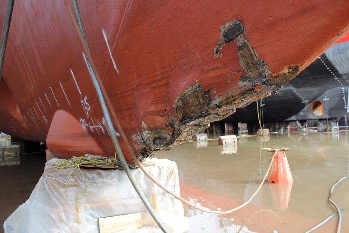
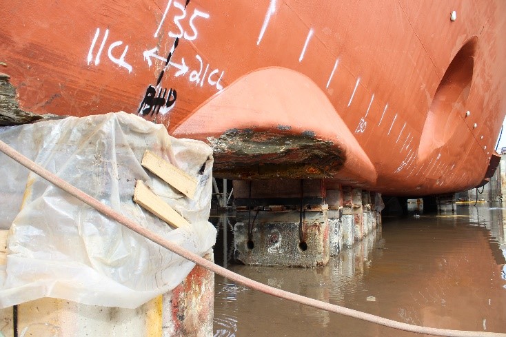
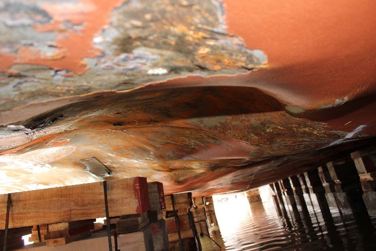
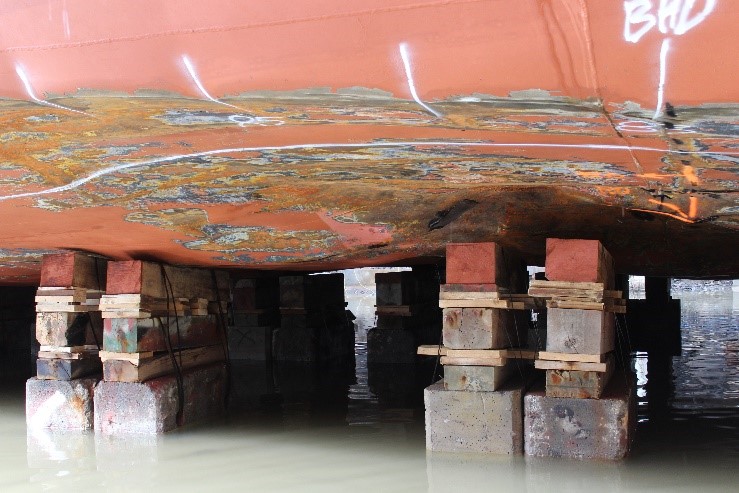
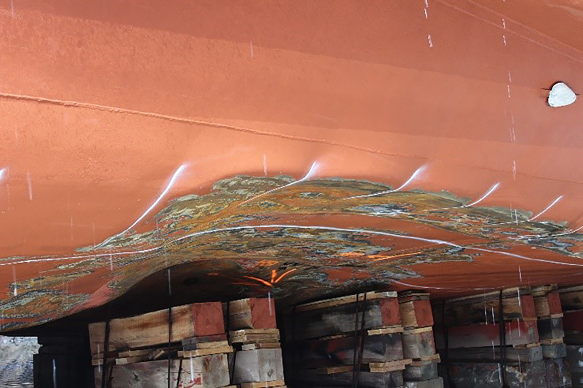
Following the grounding of the Akademik Ioffe and the subsequent attempts to refloat it, the vessel sustained extensive structural and hull damage in way of the double-bottom ballast water and fuel oil bunker tanks, from the bow to amidships (Table 2). Two fuel oil bunker tanks (No. 41 port and No. 41 centre) and 2 ballast water tanks (No. 21 centre and No. 51 port) were breached and took on seawater, flooding to their maximum capacity. Details of the damage and location of hull breaches are also provided in Figure 5.
| Tank identification | Tank location in relation to vessel keel | Damage summary |
|---|---|---|
| Forepeak tank No. 11 | Centre; frame No. 135 to 151 | Bow ice strake cracked and deformed |
| Ballast water tank No. 21 | Centre; frame No. 115 to 135 | Shell plating and internal structure cracked and deformed |
| Ballast water tank No. 31 | Port; frame No. 99 to 115 | Shell plating and internal structure cracked and deformed |
| Fuel oil bunker tanks No. 41 | Port, centre, and starboard; frame No. 83 to 99 | Shell plating and internal structure cracked and deformed |
| Ballast water tank No. 51 | Port; frame No. 71 to 83 | Shell plating and internal structure cracked and deformed |
| Cofferdam No. 53 | Centre; frame No. 63 to 83 | Shell plating and internal structure deformed |
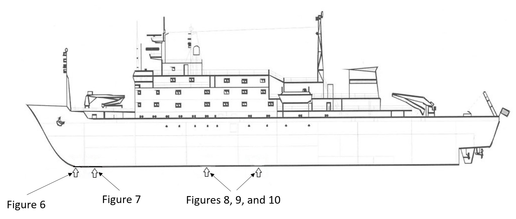
On 28 September and 03 October 2018, the TSB visited the shipyard in Les Méchins to document the hull damage sustained by the Akademik Ioffe (figures 6, 7, 8, 9, and 10).
1.7 Damage to the environment
Prior to the grounding, the vessel’s port and centre fuel oil bunker tanks No. 41 contained 0 m3 and 16 m3 of IFO respectively. Following the grounding, these 2 tanks were flooded with seawater to their maximum capacity of 158 m3 and 168 m3 respectively. The master reported to JRCC Trenton, CCG, and TC that 489 m3 of IFO and 150 m3 of MGO remained on board.
On 30 August 2018 at 1100, an aircraft from TC’s National Aerial Surveillance Program observed an oil slick on the surface of the sea in the Gulf of Boothia, 0.5 NM from the Akademik Ioffe. The volume of oil was estimated at 80.51 L, covering 0.99 km2, and was determined to be unrecoverable.
On 30 September, at 0919, in Les Méchins, while shipyard personnel were emptying the graving dock after docking the Akademik Ioffe, a mixture of seawater and IFO escaped from tanks No. 41 and contaminated the waters around the vessel. Shipyard personnel contained the oil spill to the inside of the graving dock and later recovered the fuel oil.
1.8 Environmental conditions
At the time of the occurrence, the air temperature was 1.9 °C, the skies were overcast with a visibility of 5 NM, the wind was from the north at 21 knots,Footnote 29 and the swell was from the north with waves of 1.5 m in height. The Akademik Ioffe was sailing in ice-free waters of a temperature of 1.02 °C and was taking the swell on its starboard quarter. The tide was flooding; the high tide occurred at 1549 (1.5 m), was low at 2023 (0.9 m), and was high again at 0326 (2.8 m) on 25 August 2018.
1.9 Personnel experience and certification
The master held a Master certificate of competency issued by the Russian Federation on 04 May 2018, as well as a certificate in the operational use of an ECDIS. The master’s certification was limited to vessels other than cargo and fishing vessels. He had worked for the P.P. Shirshov Institute of Oceanology of Russian Academy of Sciences (IO RAS) for 10 years in various ranks as bridge watch officer and was promoted to master 2 months prior to the occurrence; the occurrence voyage was during his first contract as master. On 01 June 2018, the master completed the mandatory advanced training for chief officers and masters of ships operating in polar waters.Footnote 30
The master gained his polar waters experience on board the Akademik Ioffe and its sister ship, the Akademik Sergey Vavilov, throughout 7 expedition cruise seasons in the Antarctic and 3 expedition cruise seasons in the Arctic; the occurrence took place during his fourth expedition cruise season in the Arctic. The occurrence voyage was the first time the master had sailed in the vicinity of the Astronomical Society Islands.
The OOW was the Akademik Ioffe’s second officer, and held a Chief Mate certificate of competency issued by the Russian Federation on 22 May 2018, as well as a certificate in the operational use of an ECDIS. The OOW’s certificate was limited to vessels other than fishing vessels. On 22 December 2017, he completed the mandatory basic training for ships operating in polar waters.Footnote 31
The occurrence voyage was his fourth contract as second officer and he previously completed 3 contracts as third officer for the IO RAS. The OOW gained his polar waters experience on board the Akademik Ioffe and its sister ship, the Akademik Sergey Vavilov, throughout 3 expedition cruise seasons in the Antarctic; the occurrence took place during his second expedition cruise season in the Arctic. The occurrence voyage was the first time the OOW had sailed in the vicinity of the Astronomical Society Islands.
The 4 certified bridge watch officers on board the Akademik Ioffe had completed and signed the IO RAS’s familiarization checklist for shipboard bridge equipment. The equipment familiarization checklist on board the Akademik Ioffe included the use of the echo sounders but did not include the ECDIS.
Additionally, as a mandatory requirement for obtaining their respective certificates of competency, the bridge watch officers had all taken standard training in bridge resource management (BRM).Footnote 32
The helmsman began his marine career in 2014 and held a Navigational Watch certificate of competency. He had worked for the IO RAS since 2016. The helmsman joined the Akademik Ioffe on 07 May 2018, and was conducting his second expedition cruise season in the Canadian Arctic on board the vessel when the occurrence took place. The occurrence voyage was the first time the helmsman had sailed in the vicinity of the Astronomical Society Islands. The helmsman had not completed any training specific to operations in polar waters, nor was he required to.
Although not required per the Akademik Ioffe’s minimum manning requirements, the expedition leader held a domestic Australian Coxswain Grade 1 (Near Coastal) certificate of training for the handling of vessels less than 12 m long.Footnote 33 Since 2007, the expedition leader had worked on vessels as a passenger guide and as a small boat operator on expedition cruises in non-polar waters, Antarctica, and in the Canadian and Norwegian Arctic. Through his work experience under approximately a dozen different expedition leaders, he eventually was promoted to expedition leader by One Ocean Expeditions. An expedition leader does not require any formal marine certification. The expedition leader had worked on the Akademik Ioffe previously, however the occurrence voyage was his first pairing with this master.
The Akademik Ioffe did not have any supernumerary ice navigator on board, nor was it required to per Canadian and international regulatory requirements.Footnote 34
1.10 Fatigue
Factors conducive to fatigue are acute or chronic lack of sleep, effects of the body’s circadian rhythm, continuous wakefulness, sleep disorders, or effects from a medication or medical conditions.
In this occurrence, International Maritime Organization (IMO)Footnote 35 and International Labour OrganizationFootnote 36 regulatory requirements regarding fatigue management were met, and no data were found indicating that fatigue contributed to the occurrence.
1.11 Vessel certification
The Akademik Ioffe was duly equipped and carried all the required certificates for a vessel of its class and for the intended voyage. Its last periodic renewal inspection was carried out on 09 June 2018 by the flag state’s recognized organization (RO) in Gdansk, Poland. The RO issued the IO RAS a document of compliance (DOC) on 15 June 2018, and issued the Akademik Ioffe a safety management certificate (SMC) on 10 June 2018.
The vessel was inspected by an RO surveyor for compliance with the Arctic Waters Pollution Prevention ActFootnote 37 on 09 June 2018 in Gdansk.
An Arctic Pollution Prevention Certificate (APPC) was subsequently issued to the vessel, although it was not required because the Arctic Shipping Pollution Prevention Regulations (C.R.C., c. 353) were repealed in December 2017.Footnote 38 The APPC stated that the vessel was carrying the most recent editions of the Canadian Sailing Directions,Footnote 39 the CanadianNotices to Mariners (NOTMAR),Footnote 40 and the Ice Navigation in Canadian Waters,Footnote 41 despite the fact that the most recent editions of these publications were not on board the vessel at the time the certificate was issued.
The APPC also prescribed the vessel’s lightest and deepest draughts while sailing the Canadian Arctic (Table 3).Footnote 42
The International Code for Ships Operating in Polar Waters (Polar Code)Footnote 43 entered into force on 01 January 2017 with an amendment to the SOLAS Convention,Footnote 44 and requires vessels operating in the defined waters of the Antarctic and Arctic to apply for a Polar Ship Certificate. Chapter II of the Polar Code requires each vessel to carry a Polar Water Operational Manual in order to provide the vessel owner, operator, master, and crew with information regarding the ship’s operational capabilities and limitations, and to support their decision-making process. A Polar Ship Certificate and its associated Record of Equipment were issued to the Akademik Ioffe on 09 June 2018 in Gdansk, and prescribed the vessel’s minimum and maximum draughts while sailing in polar waters as described in the Polar Code (Table 3). The IO RAS had approved and integrated the mandatory Polar Water Operational Manual into its safety management system (SMS – see section 1.10) on 10 November 2017.
| Name of certificate | Lightest forward draught | Lightest after draught | Deepest forward draught | Deepest after draught |
|---|---|---|---|---|
| Canadian Arctic Pollution Prevention Certificate (APPC) | 4.70 m | 4.70 m | 5.90 m | 5.90 m |
| IMO’s Polar Ship Certificate | 5.15 m | 5.89 m | 5.90 m | 6.20 m |
At its first Canadian port of call in Sydney, Nova Scotia, on 25 June 2018, the Akademik Ioffe was issued a letter of compliance for a coasting trade licence,Footnote 45 valid from 27 June 2018 to 25 September 2018, for 8 cruises from and between Louisbourg, Nova Scotia; Iqaluit; Resolute Bay, Nunavut; and Cambridge Bay.
The Akademik Ioffe initiated its expedition cruise from a Canadian location (Kugaaruk, Nunavut) not listed in the letter of compliance for its coasting trade licence.
The investigation revealed that the Canadian publications Sailing Directions, NOTMAR, and Ice Navigation in Canadian Waters were not on board the Akademik Ioffe at the time of the occurrence.
The minimum and maximum operating draughts prescribed in the APPC differed from those stated on the vessel’s Polar Ship Certificate, and that the vessel initiated the occurrence expedition cruise from a location not listed in the letter of compliance for a coasting trade licence.
In accordance with requirements, the Akademik Ioffe carried a class-approved damage control plan and damage control booklet.Footnote 46
1.12 Safety management system
The International Management Code for the Safe Operation of Ships and for Pollution Prevention (ISM Code)Footnote 47 aims to “provide an international standard for the safe management and operation of [vessels] and for pollution prevention.”Footnote 48
The objectives of the [ISM] Code are to ensure safety at sea, prevention of human injury or loss of life, and avoidance of damage to the environment, in particular, to the marine environment, and to property [...].Footnote 49 Safety management objectives of the [c]ompany should, inter alia: [...] provide for safe practices in ship operation and a safe working environment; […] assess all identified risks to its [vessels], personnel and the environment and establish appropriate safeguards; and […] continuously improve safety management skills of personnel ashore and aboard [vessels], including preparing for emergencies related both to safety and environmental protection.Footnote 50
Companies typically meet this requirement by establishing an SMS that includes standard operating procedures (SOPs) for all shipboard critical tasks, which are supported by checklists to make sure that crew members follow the procedures.
At the time of the occurrence, both the IO RAS and the Akademik Ioffe were subject to the ISM Code;Footnote 51 the RO issued the IO RAS and the vessel a DOC and an SMC respectively, as proof of compliance. As required, an ISM-compliant SMS was also being used on board the vessel.
1.12.1 Post-grounding or stranding procedures
A vessel’s SMS encompasses numerous procedures for various situations, and many of these procedures are supported by checklists to assist the crew in addressing unusual critical situations, such as the vessel running aground or becoming stranded.
Typical post-grounding or stranding checklists include standard steps for vessel crew to enact.Footnote 52 The first step is to stop the engines, followed by sounding the general alarm to alert all persons on board of the situation. Then, proper collision avoidance measures must be taken, such as exhibiting appropriate specific navigation and deck lights, shapes, and sending out sound signals.Footnote 53 Distress messages must be broadcast, flag and port state authorities must be informed, initial damage assessment and control must be conducted, and medical assistance must be provided to any injured person.
Finally, a standard post-grounding checklist requires that all pertinent information be logged, such as speed, position and time of grounding, water depths around the vessel and its draughts, tides and currents status, meteorological conditions and forecast, ECDIS, course recorder, and voyage data recorder (VDR) data. A standard post-grounding checklist typically advises a crew that attempts to refloat the vessel using propulsion, or by jettisoning cargo or other content, should be made as a last resort; such actions should only be taken if the vessel is in immediate danger of sustaining a catastrophic structural failure or of worsening the hull breaches.
Among other procedural guidelines, the SMS used on board the Akademik Ioffe includes a 30-step post-grounding checklist.Footnote 54 This checklist specifies the initial actions the crew must take following the vessel’s grounding: stop the main engines, activate the general alarm, and order the immediate mustering of everyone on board using the vessel’s PA system. A distress message must also be broadcast via the vessel’s GMDSS.
The Akademik Ioffe’s post-grounding checklist then specifies that the master must attempt to refloat the vessel.Footnote 55 The action items listed on the checklist after attempting to refloat the vessel include communications, record keeping, collision avoidance measures, pollution prevention, damage control and preserving the hull’s water tightness, preparing lifesaving appliances for use, passenger head count and assistance (e.g., first aid), organizing the vessel’s salvage, and taking measures for post-salvage inspections, repairs, and investigations.
The Akademik Ioffe’s shipboard post-grounding checklist required the master to attempt refloating the vessel after mustering the entire complement, but before carrying out a damage assessment that included the integrity of the hull and its appendages.
Following the grounding, the crew completed the vessel’s post-grounding checklist, which was signed off by the master, chief engineer, OOW, and the second engineer.
1.13 Voyage planning
1.13.1 Guidelines on voyage planning
1.13.1.1 International Maritime Organization
According to the SOLAS Convention, a voyage or passage plan must be completed by every vessel before it proceeds to seaFootnote 56 and should take into account the IMO’s guidelines on voyage planning,Footnote 57 which consists of 4 stages.
The first stage of voyage planning involves appraisal by the bridge watch officer of all the available information about the intended voyage, which includes reviewing navigation charts and publications. More specifically, the charts carried on board should be up to date and to the appropriate scale, and all the permanent and temporary NOTMARs and radio navigational warnings relevant to the voyage should be consulted. As well, all necessary and pertinent documentation such as lists of lights, radio aids to navigation, current and tidal atlases, tide tables, weather routing services, and sailing directions should be accurate and updated. This appraisal should indicate dangerous areas (also known as no-go areas) and areas where special precautions must be taken. It should also take into account the vessel’s condition such as stability, operational limitations, and manoeuvring characteristics.
The second stage of voyage planning involves preparing a detailed voyage or passage plan, “which should cover the entire voyage or passage from berth to berth, including those areas where the services of a pilot will be used.”Footnote 58 The vessel’s safe speed with regard to the proximity of navigational hazards, its draught in relation to the available water depth, and the minimum under-keel clearance are included in the cited “main elements to ensure safety of life at sea, safety and efficiency of navigation, and protection of the marine environment during the intended voyage or passage.” Additionally, “contingency plans for alternative action to place the vessel in deep water or proceed to a port of refuge or safe anchorage in the event of any emergency necessitating abandonment of the plan” must be “clearly marked and recorded,” and “be approved by the ships’ [sic] master prior to the commencement of the voyage or passage.”Footnote 59
The third stage of voyage planning is the execution of the passage plan, taking into account all prevailing conditions and factors such as the reliability and condition of the vessel’s navigation equipment, and meteorological conditions. The Guidelines for Voyage Planning also note that “[t]he master should also consider at which specific points of the voyage or passage there may be a need to utilize additional deck or engine room personnel.”Footnote 60
The fourth and final stage of voyage planning is the close and continuous monitoring of the vessel’s progress throughout the execution of the plan.Footnote 61 This includes gathering pertinent local warnings for the intended voyage, such as any reconnaissance data notation on local navigation charts.
1.13.1.2 The International Chamber of Shipping
The International Chamber of Shipping (ICS), based in London, United Kingdom, is an international trade association for merchant vessel owners and operators established in 1921. The ICS says it represents over 80% of the world merchant fleet.Footnote 62 Based on IMO guidelines and SOLAS requirements, in 1997 the ICS produced and has since re-issued its Bridge Procedures Guide,Footnote 63 which is commonly known and referred to in the global marine industry.
This publication provides guidance for bridge teams and discusses passage planning in a dedicated chapter. The guide indicates that, before voyage planning can commence, a passage plan appraisal must be completed by the vessel’s bridge watch officers, which includes gathering and studying the charts, publications, and other information appropriate for the voyage. Only official nautical charts and publications are to be used for voyage planning and must be corrected to the latest available NOTMARs and local area warnings; largest scale charts should always be used.
The guide also emphasizes crew familiarization with ECDIS and cautions against overreliance on this specific type of system. Specifically, “[d]ue to the screen resolution of ECDIS, the precision of charted objects on ECDIS may not be substantially different from that of paper charts.” The guide further warns OOWs planning a voyage on ECDIS that “the charted objects on an [electronic chart] are not more accurate or precisely plotted than charted objects on the corresponding […] paper chart […].”Footnote 64
Prior to the Akademik Ioffe’s grounding, the bridge team had been using the shipboard ECDIS on a scale of 1:250. This scale provided an over-zoomed view of the narrows between the Ross Peninsula and the Astronomical Society Islands when compared to the same chart (7502) in paper format that uses a scale of 1:500 000.Footnote 65
1.13.2 Vessel owner requirements
The IO RAS’s SMS includes numerous standard operating procedures (SOPs) and checklists regarding navigation safety and proper passage or voyage planning.
The IO RAS’s Navigation, Coastal Waters/Traffic Separation Schemes checklist requires that all charts and nautical publications be correct and up to date, and that the bridge watch officer preparing the passage plan consider the advice and recommendations stated in pertinent sailing directions, as well as factors such as the vessel’s draught, the effect of squatFootnote 66 on the vessel’s under-keel clearance in shallow water, the tides, the currents, and the weather. The checklist also stresses the need to ensure the intended laid courses are well clear of obstructions.
The Preparation for Sea checklist requires that a passage plan for the intended voyage be prepared, taking into consideration the factors listed in the Navigation, Coastal Waters/Traffic Separation Schemes checklist. Excerpts from IMO Assembly Resolution A.893(21) are annexed to the Preparation for Sea checklist. The checklist requires that charts for the intended voyage and other nautical publications be correct and up to date, and the planned courses must be plotted on those charts. Two of the checklist’s appendices repeat excerpts from Section 2 of the ICS’s Bridge Procedures Guide.
The Navigation in Narrows checklist requires that crew consider the same factors as those cited in the Navigation, Coastal Waters/Traffic Separation Schemes checklist. Additionally, enough personnel must be present on the navigation bridge and in the engine room,Footnote 67 the sonar (echo sounder) readings must be compared with the water depths recorded on the chart, and the vessel must be steered in manual mode after the crew checks the functioning of the steering gear.
Prior to the occurrence, Navigation, Coastal Waters/Traffic Separation Schemes and Preparation for Sea checklists were completed and signed off by the master. The Navigation in Narrows checklist had been completed and signed off by the OOW before entering the narrows between the Ross Peninsula and the Astronomical Society Islands.
1.13.3 Voyage planning for passenger ships operating in remote areas
The IMO notes that vessels operating in remote areas like the Arctic and the Antarctic are exposed to a number of risks, such as the surrounding environment, limited resources, a lack of good and reliable navigation charts, and the fact that the lack of communication systems and other navigational aids may pose a challenge for mariners. The IMO also recognizes the need to develop further guidelines to supplement its basic guidelines on voyage planning, particularly for passenger ships operating in remote areas, in order to prevent groundings and collisions. Consequently, in 2007, the IMO adopted guidelines on voyage planning to specifically address the growing popularity of passenger vessels visiting remote destinations.Footnote 68
These guidelines indicate that voyage planning should take into account the source, date, and quality of the hydrographic data of all navigation charts used for the intended voyage. The safe and no-go areas as well as the availability of the surveyed marine corridors should be verified, and contingency plans for emergencies in the event of limited SAR resources should be documented. Additionally, extraordinary attention should be given to voyage planning in ice-infested waters and in waters where icebergs are present.
These supplementary guidelines also stress the need to report all changes to or deviations from the vessel’s initial voyage or passage plan to relevant authorities while that plan is being executed.Footnote 69
In addition to its Guidelines on voyage planning for passenger ships operating in remote areas, the IMO developed and published Guidelines for ships operating in Arctic ice-covered watersFootnote 70 in 2002, and Guidelines for ships operating in polar waters in 2010.Footnote 71 The 2002 and 2010 guidelines emphasize that the prevailing challenges for vessels and mariners sailing in waters such as the Canadian Arctic are similar to those faced by vessels and mariners sailing in other remote areas, identifying the “[p]oor weather conditions and the relative lack of good charts, communication systems and other navigational aids” present in the Arctic environment.Footnote 72
In addition to the various IMO guidelines, the Canadian Charts and Nautical Publications Regulations, 1995, stipulate that “[t]he master of a ship shall ensure that the charts, documents and publications required by these Regulations are, before being used for navigation, correct and up-to-date, based on information that is contained in the Notices to Mariners,Notices to Shipping or radio navigational warnings.”Footnote 73
1.13.4 One Ocean Expeditions’ pre-set itineraries
The Akademik Ioffe’s expedition cruise followed one of One Ocean Expeditions’ pre-set itineraries entitled Pathways to Franklin; it was supposed to begin in Resolute Bay on 23 August 2018 and end in Cambridge Bay on 01 September 2018. A total of 8 intermediate stopovers were planned along the intended route, and One Ocean Expeditions had alternative destinations and itineraries (called plans A, B, C, etc.) should circumstances such as adverse weather conditions affect the original plan. The expedition cruise was designed to “maximi[ze] opportunit[ies] [with a] flexible and adventurous mindset.”Footnote 74
Due to the reported ice accretionsFootnote 75 off Resolute Bay that prevented the transfer of the passengers by inflatable boat from the beach to the Akademik Ioffe, One Ocean Expeditions diverted the expedition cruise and initiated it in Kugaaruk. Accordingly, the itinerary was modified to reflect this departure point, and the Hecla and Fury Islands were chosen as the first stopover in the expedition cruise. A charter aircraft flew from Edmonton, Alberta, to Kugaaruk on 23 August 2018 carrying the cruise passengers and some of the expedition staff, including the expedition leader.
As with previous expeditions, once the expedition leader boarded the Akademik Ioffe on 23 August 2018, he assumed the responsibility of adapting the expedition cruise itinerary to suit the ever-changing local environmental conditions, while updating One Ocean Expeditions’ shore office of any deviation or new itineraries. To fulfill this responsibility, the expedition leader had to keep in mind various itineraries with alternate destinations, like the Astronomical Society Islands, in case environmental conditions prevented landing passengers at the planned destination, as was the case in this occurrence.
There was no preapproved passage plan for any of the expedition leader’s alternate itineraries or destinations; once the expedition leader requested that the vessel be redirected toward a particular destination, it was the responsibility of the Akademik Ioffe’s master to plan the requested alternate passage and assess its feasibility and safety.
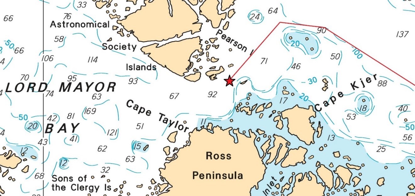
In this occurrence, when the expedition leader asked if the master could re-direct the vessel toward Lord Mayor Bay on the western side of the Astronomical Society Islands, the master referred to the local Canada-issued navigation chartFootnote 76 and Russia-issued sailing directionsFootnote 77 to assess the feasibility of the sea passage. The chart showed 3 sounding points in the narrows between the Ross Peninsula and the Pearson and Astronomical Society Islands: 71 m, 92 m, and 67 m respectively from east to west. The most confined point of passage between landmasses was approximately 1.5 NM, with no indicated navigational hazard (Figure 11). The Russia-issued sailing directions did not provide any specific warning for the area of occurrence.

There was no active national Navigational Warning (NAVWARN, formerly known as Notice to Shipping or NOTSHIP), Notice to Mariners (NOTMAR), or Navigational Telex (NAVTEX)Footnote 78 for the concerned area. The Akademik Ioffe did not carry the local CHS’s Sailing Directions (ARC 400E and ARC 402E).
Vessels can also access the west side of the Astronomical Society Islands by sailing just north of and around the islands, between them and Cape North Hendon, where a line of spot soundings shows water depths of 149 m, 156 m, 143 m, and 134 m. The most confined point of passage between lands is approximately 7 NM with no reported shoal. The investigation could not determine the exact water depths nor the nature of the seafloor between these soundings.
The revised passage plan produced by the master noted that the minimum water depth the vessel could encounter was 50 m. This parameter was not set as a low water depth aural alarm on any of the vessel’s echo sounders.
1.14 Arctic waters regulatory framework
In the past, the IMO has put into place various requirements, provisions, and recommendations to address the safety risks inherent to vessels operating in the harsh, remote, and vulnerable polar areas, and to protect the environment around the 2 poles. Because the volume of marine traffic in polar waters continues to grow, additional measures had to be taken to ensure the safety of life at sea and the sustainability of the polar environments. The IMO has identified poor weather conditions and the relative lack of good navigation charts, communication systems, and other navigational aids among the risks to vessels operating in the Arctic and Antarctic. The IMO also acknowledges the challenges of search and rescue operations, and pollution recovery operations, given the remoteness of polar waters. Finally, the IMO has stated that the cold temperatures prevailing in polar areas may affect the exposed equipment of a vessel, such as deck machinery, emergency equipment, and seawater suctions; ice accretion can also impose additional loads on the hull, propulsion system, and hull appendages.Footnote 79
In addition to established regulatory tools and guidance, the IMO adopted the Polar Code and enforced it by amending the existing SOLAS, MARPOL,Footnote 80 and STCW conventions. The Polar Code applies to vessels proceeding to a destination within polar waters or transiting through them to reach its destination. The Polar Code is goal based and covers the full range of the design, construction, and equipment of vessels. The code also prescribes requirements for the operational and training levels for seafarers, with an increased attention to matters such as search and rescue, and the protection of the environment.Footnote 81
The IMO acknowledges that while the Polar Code covers both the Arctic and Antarctic waters, there are significant differences between the 2 polar areas. While the Antarctic is a continent surrounded by an ocean, the Arctic is an ocean surrounded by continents; this characteristic contributes to a significant amount of multi-year sea iceFootnote 82 being present in the Arctic Ocean. Therefore, although “the marine environments of both Polar seas are similarly vulnerable, response to such challenge should duly take into account specific features of the legal and political regimes applicable to their respective marine spaces.”Footnote 83
Headquartered in Hamburg, Germany, the International Union of Marine Insurance (IUMI) represents over 40 national and marine market insurance and reinsurance associations. The IUMI has been an active supporter of the adoption of the IMO’s Polar Code, which it believes “lowers the risks by making vessel owners better prepared and prevents transits that do not meet the safety standards for operating in the Arctic.”Footnote 84 The IUMI notes, concerning the increasing global marine traffic in polar waters, that “[t]ransits have also been made through the Northwest Passage […].Footnote 85 Within the cruise industry, today’s focus is more on expedition cruises with smaller custom-built vessels destined for Arctic waters to offer guests a more “intimate experience”. Several of these vessels are now on order.”Footnote 86
Among the potential risks of carrying passengers in the Arctic, the IUMI names
[h]arsh and fast-changing conditions with less reliable ice and weather forecasts, restricted visibility up to 90% of the time, insufficient charts based on inadequate and old surveys, unreliable positioning systems and compasses in high latitudes, drifting sea and icebergs, inadequate training of the crew, and limited access to communication links and search and rescue facilitiesFootnote 87
In Canada, in addition to the Polar Code, marine navigation in the Arctic is governed by a specific domestic regulatory framework under the Arctic Waters Pollution Prevention ActFootnote 88that includes the following: Arctic Shipping Safety and Pollution Prevention Regulations; Arctic Waters Pollution Prevention Regulations; Governor in Council Authority Delegation Order; Shipping Safety Control Zones Order; and Steering Appliances and Equipment Regulations.Footnote 89
The CCG mentions that
[t]he Arctic Shipping Pollution Prevention Regulations (ASPPR) deal with construction and operational aspects of navigating in the Arctic, including the need for Ice Navigators. The ASPPR contains the Zone/Date System, which is a system dividing the Arctic into 16 Safety Control Zones, each with fixed opening and closing dates for ships of various ice capabilities. The Arctic Ice Regime Shipping System (AIRSS) was introduced as a more flexible system that uses the actual ice conditions to determine whether entry is allowed in an ice regime.Footnote 90
As a requirement under the Arctic Shipping Safety and Pollution Prevention Regulations, the regulatory standard AIRSS was established by TC. The AIRSS “is intended to minimize the risk of pollution in Arctic waters due to damage of vessels by ice; to emphasize the responsibility of the shipowner and master for safety; and to provide a flexible framework for decision-making.”Footnote 91 TC has published TP 12259, in which ice regime is defined as “a description of an area with a relatively consistent distribution of any mix of ice types, including open water.”Footnote 92 The ice regime takes into account several important factors of the ice: its concentration, thickness, age, state of decay, and roughness.
1.15 Northern Canada Vessel Traffic Service Zone
Implemented in 1977, Northern Canada Vessel Traffic Services (NORDREG) tracks marine traffic in Canadian waters north of latitude 60° North, as well as within Ungava Bay and the southern part of Hudson Bay. NORDREG is operated by CCG personnel from Marine Communications and Traffic Services (MCTS) in Iqaluit, is free of charge to vessel owners, shares information on ice conditions, gives advice on ice routes, provides icebreaker support where available and necessary, and facilitates SAR response. In 2010, regulationsFootnote 93 were enacted under the Canada Shipping Act, 2001, to require vessels sailing in the NORDREG zone to report their locations and itineraries to NORDREG.
To comply with the mandatory reporting scheme, masters of vessels within the NORDREG zone are required to submit 4 different types of reports: a Sailing Plan (SP), which is required before entering the zone or departing a berth within the zone; a Position Report, which is required upon entry in the zone and then daily at 1600 Coordinated Universal Time (UTC) thereafter; a Final Report, which is required upon arrival or departure from berth and immediately before exiting the zone; and a Deviation Report (DR), which is required whenever a vessel deviates from the route or position previously submitted in its SP.Footnote 94
NORDREG verifies that the reports required under its regulations are submitted by vessels, and that these reports contain all necessary information. NORDREG has no authority to order, direct, or instruct a vessel to go somewhere within the zone. Similarly, NORDREG has no authority to prohibit a vessel from going somewhere within the zone. If NORDREG personnel become aware of a vessel contravening its regulations, the transgression is declared to TC, which can enact compliance and enforcement measures against the vessel.
Following the receipt of an SP or a DR from a vessel, NORDREG relays it to TC, which then verifies that the vessel’s ice class is sufficient to sail through the ice regime(s) the vessel expects to encounter. If the vessel was not built to an ice class sufficient to proceed through the expected ice regime(s), TC requires, via NORDREG, that the vessel submit an alternate route, following a formal template called an ice regime routing message, pursuant to the AIRSS. TC is then responsible for endorsing or denying the alternate route.
It is within TC’s mandate to assess a vessel’s ice navigation capabilities against existing ice conditions. NORDREG serves as a communication intermediary between the vessel and TC for the information exchange; NORDREG does not have the mandate, expertise, or regulatory authority to assess the safety of a vessel’s intended passage for hazards.
On 23 August 2018, NORDREG received an SP from the Akademik Ioffe; this report was for a transit from Kugaaruk to Cambridge Bay and specified a stopover at the Hecla and Fury Islands. On 24 August, after the expedition leader changed the voyage destination from the Hecla and Fury Islands to the Astronomical Society Islands, the master prepared a DR and sent it to NORDREG at 0738. The DR informed NORDREG that the passage plan was changed, with 6 new waypoints and a course through the narrows between the Ross Peninsula and the Pearson and Astronomical Society Islands, entering Lord Mayor Bay.
NORDREG relayed the DR to TC, which assessed the vessel’s ice class for its fitness to proceed through the expected ice regime and found it compliant; the authorization was sent back to NORDREG, which replied to the Akademik Ioffe, 23 minutes later, that
Transport Canada finds your routing message […] in compliance with the Arctic Ice Regime Shipping System of the Arctic Shipping Safety and Pollution Prevention Regulations […]. NORDREG Canada clears AKADEMIK IOFFE/UAUN to depart from its PRESENT POSITION and proceed in the Northern Canada Vessel Traffic Services Zone to ASTRONOMY SOCIETY ISLANDS [sic] […].Footnote 95
The message also emphasized that mariners must navigate with extreme caution around and within ice-infested waters, and an ice chart of the area was attached.
Beyond its ice regime assessment, TC does not currently assess the feasibility or safety of any vessel’s passage plan.
The increase in marine cruise and expedition passenger-carrying traffic within the NORDREG zone is observable from CCG statistics.Footnote 96 CCG numbers show a steady increase in the number of passenger vessels and voyages made in the NORDREG zone from 2010 to 2019, with a steeper increase starting in the 2015 season. The total number of passenger vessels (cruise vessels) operating in the Canadian Arctic increased from 11 in 2010 to 15 in 2019, with larger vessels carrying more passengers. The number of people on board passenger vessels, including crew, remained steady from 2010 to 2014 and more than doubled from 2015 to 2019. The total number of passengers on those cruise vessels increased over the past decade from 3424 passengers in 2010, to 8382 passengers in 2019.
Comparable trends are identified in CCG statistics with regard to other types of vessels and their voyages in the NORDREG zone from 2010 to 2019. The total number of vessels active in the Arctic increased from 145 in 2010 to 191 in 2019. The total number of full transits of the Northwest Passage increased from 19 in 2010 to 27 in 2019, with a peak of 34 full transits in 2017, and a low of 5 in 2018.Footnote 97
1.16 Charting in the Canadian Arctic
1.16.1 Role and mandate of the Canadian Hydrographic Service
According to the Oceans Act,Footnote 98 the Minister of Fisheries, Oceans and the Canadian Coast Guard is responsible for the Government of Canada’s policies and programs regarding oceans. Among other responsibilities, the Minister provides hydrographic services to promote safe marine navigation and facilitate maritime trade and commerce. Through the Canadian Hydrographic Service (CHS), the Minister may conduct hydrographic and oceanographic surveys of Canadian and other waters, and prepare and publish data, reports, statistics, charts, maps, plans, and other documents.
According to the regulationsFootnote 99 enacted under the authority of both the Canada Shipping Act, 2001, and the Arctic Waters Pollution Prevention Act, vessels must carry up-to-date charts and other nautical publications necessary for their intended voyage, made by or under the authority of the CHS.
The CHS is also responsible for ensuring that Canada fulfills certain international obligations. The SOLAS Convention requires contracting states such as Canada to provide hydrographic services adequate for the needs of safe navigation as well as adequate, up-to-date charts and publications for all ships. .Footnote 100 The CHS is also responsible for producing charts or publicizing the coordinates for Canada’s maritime boundaries, as required under the United Nations Convention on the Law of the Sea. Finally, the CHS works with the IMO to establish ECDIS carriage requirements.
The CHS delivers its services by performing targeted hydrographic surveys, which provide data to map the seafloor, and communicating this information to mariners via electronic and paper navigational charts. These authoritative products are maintained and updated with new information on a continual basis via NOTMAR. The CHS also operates a network of tide gauges, which provide real-time measurements of sea or lake levels, and inform tide tables.
1.16.2 Data quality and survey standards
The CHS does not have vessels dedicated to data collection in the Canadian Arctic and relies primarily on CCG vessels and other vessels of opportunityFootnote 101 to deploy its survey launches. This means that the CHS collects data in areas where the CCG is already operating; for example, while CCG icebreakers are on standby for ice escorts. The CHS also partners with other federal departments, territorial governments, and academic organizations for data collection, such as the Royal Canadian Navy, Natural Resources Canada, Parks Canada, and ArcticNet.Footnote 102 The CHS conducts surveys in the Canadian Arctic mainly based on opportunity and is therefore often challenged to address the higher risk areas first.Footnote 103
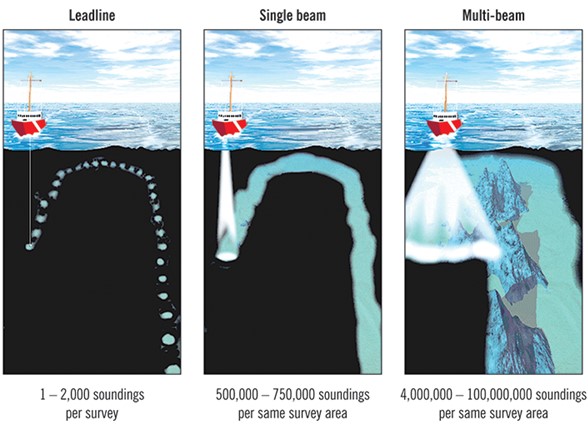
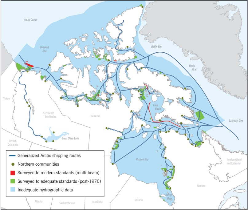
The remoteness, harsh meteorological conditions, seasonal and permanent sea ice coverages, and the historically low marine traffic in Canadian Arctic waters are factors that impact the quality of hydrographic data collected, some of which are decades old. In 2014, only about 1% of Canada’s Arctic waters were surveyed to modern standards.Footnote 104 By April 2019, 14% of Canada’s Arctic waters had been surveyed to modern or adequate standards.
In the CHS’s Sailing Directions ARC 400, mariners are warned that “[i]n some areas, spot soundings through the ice or reconnaissance track soundings are the only survey data available.”Footnote 105
Spot soundings through the ice are single depth measurements taken at 2000 m intervals, commonly referred to as through-ice bathymetry. Depth measurements are taken through the ice with a fixed grid-spaced single beam sounding: a transducer is physically placed on the ice and a single depth and position reading is recorded. The hydrographer is transported between the grid-spaced sites by helicopter. The shape of the seafloor between the recording sites is unknown and can only be inferred.
Reconnaissance track sounding is another technique used to record depth measurements, where a vessel of opportunity records the water depths and vessel positions along its sailing path or track (the technique may be digital or analog). Typically, the track is a single pass with no offsetting or reciprocal lines and in which case, the level of accuracy is uncertain and no information is collected about depths on either side of the vessel’s track.
The CHS’s Sailing Directions ARC 402 issue the following cautions for the area of the occurrence:
- The depths in Prince Regent Inlet and Gulf of Boothia are based on reconnaissance surveys and ships’ track soundings. Much of this area is not surveyed to modern standards. A spot sounding survey through the ice, with a grid spacing of about 1 mile, was made in 1984 and some additional inshore depths were obtained. Soundings on charts of Bellot Strait and approaches are based on controlled and uncontrolled surveys made from 1957 to 1959. Committee Bay was surveyed from 1984 to 1992; these were reconnaissance surveys with 2 km between soundings;
- The magnetic compass is unusable in Prince Regent Inlet and Gulf of Boothia and erratic in Committee Bay.Footnote 106
Additionally, Sailing Directions ARC 402 describe the Astronomical Society Islands as being
[…] rocky, rounded, bare and uniform in height; they are higher on their west sides where they rise to over 213 m […]. From air photos there appears to be deep water close to the shores of Astronomical Society Islands and in the channels between them.Footnote 107
The area where the Akademik Ioffe ran aground is a very remote portion of the Canadian Arctic, normally covered in ice for much of the year, and has a short navigation season; mariners consider the navigational aids and references for this region (except for main shipping corridors) to be somewhat unreliable. Mariners are cautioned to continuously run an echo sounder in these waters and to use the largest scale chart available.Footnote 110, Footnote 109
The CHS navigation chart 7502, which was used on board the Akademik Ioffe (in paper and electronic format) at the time of the occurrence includes a note to mariners that the information used to establish water depths was of a reconnaissance nature and collected from CHS spot sounding surveys from 1984 to 1992, at a spacing of 2000 m, as well as track soundings from other agencies. Another inset on this chart elaborates on the 2 above-described types of reconnaissance data used for the portrayal of the seafloor.Footnote 110
Following the occurrence, the CHS issued, via the CCG’s NAVWARN A111/18, a warning indicating the location and depth of the rocky shoal on which the Akademik Ioffe had run aground. The CCG later published a formal NOTMAR on 12 October 2018 correcting navigation chart 7502, which cancelled the NAVWARN A111/18.
In October 2018, a study was released by the CHS as part of a project for satellite-derived bathymetry using empirical, photogrammetric, and classification modelling. The Canadian Space Agency funded this project, which was designed to investigate the potential of remote sensing and improve the chart production process of the CHS. This satellite-derived bathymetry would allow the CHS to identify new shoals and rocks, and to extract isobaths. This method of chart production is still at a developmental stage.Footnote 111
1.16.3 2014 Fall Report of the Commissioner of the Environment and Sustainable Development, Office of the Auditor General of Canada
In 2014, the Office of the Auditor General of Canada published a report from its Commissioner of the Environment and Sustainable Development. Chapter 3 of the report addressed marine navigation in the Canadian Arctic, where the Commissioner reported that although it was not reasonable to expect the entire Canadian Arctic to be surveyed to modern standards, it was expected that reliable information for the higher risk areas, where vessel traffic was most prevalent such as approaches to northern communities, be available.
The report gave a description of the factors affecting hydrographic data collection quality:
The quality and accuracy of nautical charts depend on the data used to produce them. Modern charts are compiled from hydrographic surveys conducted on vessels equipped with sonar technology that measures water depths, while satellite navigation systems, such as the global positioning systems, determine the precise geographic positions of the vessels’ soundings. Data collected through post-1970s technology, including single-beam sonar technology, is referred to as “surveyed to adequate standards.” Data collected through multi-beam sonar technology that became commercially available in the 1990s is referred to as “surveyed to modern standards” [Figure 12].Footnote 112
Chapter 3 noted that the CHS conducted an assessment of the paper navigation charts covering the Canadian Arctic. The assessment was based on factors such as chart age (10% of charts for the Arctic date from 1970 or earlier), the reference system used to establish data positions, and whether more recent information not included in the charts was available. The assessment found less than 25% of the paper charts in the Canadian Arctic to be “good.”Footnote 113
The report also noted that
[…] large areas of Canadian Arctic waters, including many of the main traffic corridors, have either non-existent or inadequate hydrograph[ic] data coverage. The CHS estimates that about one percent of Canadian Arctic waters are surveyed to modern standards [Figure 13].Footnote 114
Moreover, the report noted that
[t]he charts based on data collected through hydrographic surveys that do not meet adequate or modern standards generally have a high likelihood of undetected hazards and uncertainty in position of the data.Footnote 115
Chapter 3 of the Commissioner’s report also stated that
[w]hile demands for charting in the Arctic are growing, the CHS’s resources to do hydrographic work in the Arctic have recently declined. This is an additional challenge on top of a lack of dedicated vessels for conducting surveys, the size and remoteness of the Arctic waters, and the short season in which to carry out the work.Footnote 116
The Commissioner recommended that the CHS identify and prioritize the areas of the Arctic region that need to be surveyed and charted. The report also recommended that the CHS develop a long-term implementation plan with cost estimates, timelines, and options that could include collaboration with partners, alternative service delivery, and the use of modern technologies. The CHS agreed with both recommendations.Footnote 117
1.16.4 Present and future developments in charting the Canadian Arctic
Prior to 2016, CHS data acquisition and charting strategies in the Canadian Arctic focused hydrographic resources mostly where vessels traditionally transit, called low impact shipping corridors (LISC). However, this occurrence happened outside of these corridors. Since 2016, the CHS has received additional funding to fulfill its mandate. This funding allows it to arrange time periods during which CCG vessels are dedicated to hydrographic surveying in the Canadian Arctic, and to contract commercial hydrographic survey providers to work on high-priority locations. The CHS reported that by June 2019, the coverage in LISCs to adequate or modern hydrographic surveying standards was around 31%.
Additionally, the CHS plans to chart Canadian Arctic waters to modern hydrographic standards using a federal program that funds the incremental installation of modern hydrographic sonars, or multi-beam echo sounders, on CCG ice-breaking vessels. This program aims to collect modern hydrographic data while the CCG vessels transit the Canadian Arctic for other purposes (scientific research, sealift of supplies to remote communities, escorts of merchant vessels through ice-infested waters, and SAR standby posture), thereby gradually increasing the amount of data available to the CHS with each vessel pass.
At the time of the occurrence, 4 CCG ice-breaking vessels were equipped with multi-beam echo sounders and 2 more vessels were scheduled to be fitted with this equipment by 2020. The CHS emphasizes the importance of this technology to its strategy by noting that more than 50% of all modern hydrographic data collected for Canadian Arctic waters is a direct result of opportunistic multi-beam echo sounder data collected by the CCG vessel Amundsen alone since the vessel was fitted with this hydrographic data collection technology in 2003.
The use of remote sensing tools, such as satellite imagery for direct hydrographic observations, is a developing technology that is not fully integrated into the CHS’s standard operations. Since 2017, the CHS has been involved in discussions with the IHO and hydrographic organizations from other states about implementing remote sensing tools in hydrography. In 2018, the CHS published its first chart using satellite data as source data, and shared its experience using satellite imagery with its IHO partners during the IHO’s October 2018 Council. The IHO continues to assess the technology as it develops and to provide advice and guidance to its member states, including Canada.
The CHS intends to integrate remote sensing and satellite-derived bathymetry, among other technologies, to its strategy to achieve modern standard hydrography for Canadian Arctic waters. Other states’ hydrographic organizations have successfully used remote sensing and satellite-derived bathymetry technologies in water depths up to 20 m, although the technologies’ effectiveness can be reduced by poor weather conditions, water turbidity, erosion, and sedimentation.
The CHS warns that although satellite imagery can positively identify the location of potential hazards to navigation, this does not imply or guarantee that hazards do not exist if they were not identified. For instance, the CHS points out that this lack of reliability is particularly relevant in the context of this occurrence; all 4 vessels involvedFootnote 118 were provided with information derived from satellite imagery (Appendix B), but all 4 vessels are of a small displacement, with operational draughts ranging from 5 m to 7 m. The turbidity of the seawater, the presence of ice, and unfavourable weather conditions may prevent the satellite imagery from detecting a shoal that could present a hazard to navigation for larger vessels operating at deeper draughts.
Since 2014, the CHS has published 42 new electronic navigational charts (ENCs) and produced 70 new edition ENCs for Canadian Arctic waters. The CHS currently does not have a timetable to collect hydrographic data for all Canadian Arctic waters that would comply with modern international standards of hydrography.
1.17 Navigational watchkeeping
In 2001, the International Council of Cruise Lines (ICCL)Footnote 119 conducted a study on critical safety factors on board large passenger vessels.Footnote 120 The study noted that water depth information and aids to navigation were among several factors associated with a vessel running aground under power.
The study emphasized that
[…] unnecessary distraction to the OOW […] is a potential problem. About 40% of all serious accidents with cruise vessels have been related to navigation […] and in [a …] formal safety assessment on cruise ship navigation, performed in Norway in [2002 and 2003], all experts ranked distraction of the OOW as the most severe challenge […].Footnote 121
Additionally, the STCW Code stipulates that
[t]he duties of the lookout and helmsperson are separate and the helmsperson shall not be considered to be the lookout while steering […]. The officer in charge of the navigational watch may be the sole lookout in daylight provided that, on each such occasion[,] the situation has been carefully assessed and it has been established without doubt that it is safe to do so [and] full account has been taken of all relevant factors, including, but not limited to: state of weather[,] visibility[,] traffic density[,] proximity of dangers to navigation[,] and the attention necessary when navigating in or near traffic separation schemes […].Footnote 122
The OOW was the sole person actively navigating the Akademik Ioffe in the narrows at the time of the occurrence. The OOW also acted as the single lookout while the helmsman was at the helm; although the OOW’s attention was also focused on the navigation equipment, it was not focused on either of the 2 echo sounders until 35 seconds before the grounding.
1.17.1 Bridge resource management
Since the early 1990s, the concept of bridge resource management (BRM) has formed the core of the team approach in effective marine operations in both normal and emergency shipboard operations. BRM is the effective management and use of all resources, both human and technical, available to the bridge team to ensure the safe completion of the voyage. Effective communication, teamwork, problem solving, decision making and situational awareness are central to the BRM concept.Footnote 123
In addition to performing their regular duties, navigating officers have a responsibility to work as a team to ensure a shared understanding of how the voyage will progress and to deal with emergencies as they arise. Specifically, bridge team members have a responsibility to maintain overall situational awareness and perform their individual duties.
Bridge team members also have a duty to work as a team to help prevent single-point failure, which may occur when only 1 person is responsible for a safety-critical task without back-up to help identify possible errors. BRM entails communicating effectively, taking an active role in navigation and monitoring, and making use of all available navigational information to identify equipment errors or human errors.
Typically, BRM training includes cultural awareness, briefing and debriefing, challenge and response, authority workload and stress, human factors, decision making, and crisis management. From a human performance standpoint, the critical aspect of BRM rests in teamwork and effective communication among bridge team members to establish a shared and common awareness of the situation. A bridge team must exchange information to be effective.Footnote 124 In addition, team performance is characterized by each team member monitoring one another’s performance, and team members providing feedback to each other.Footnote 125
The SMS used on board the Akademik Ioffe included provisions for effective BRM during normal navigational watches, and to increase the number of navigational watchkeepers in certain operational circumstances such as sailing the vessel through narrows. Prior to the occurrence, and once the helmsman had been reassigned from lookout to hand steering the vessel, no additional crew was requested or assigned to support the OOW with vessel navigation. The OOW was therefore the sole navigator, simultaneously acting as a lookout and monitoring all the bridge equipment.
1.17.1.1 Communication, teamwork, and decision making
Crew interaction is procedurally designed to be open so that crew members can effectively transfer information and interpret workflow in abnormal, high-stress situations. Bridge watch officers and crew should crosscheck and cross-question each other, using language that is commonly understood. Discussions among crew members are essential for learning and refining BRM.
Communication as a means to achieve effective problem solving creates a shared understanding of the situation, the nature of the problem, the cause of the problem, the meaning of available cues, what is likely to happen in the future (with or without action by the team members), the goal or desired outcome, and the solution strategy (what will be done, by whom, when, and why).Footnote 126
The team approach permits all crew members to problem-solve. Resilient teams are watchful, anticipate dangerous situations, and can recognize the development of an error chain.Footnote 127 Ideally, intra-team communications should correspond to shipboard culture where the leadership hierarchy permits open communication channels commensurate with personnel expertise.Footnote 128
1.17.1.2 Situational awareness
To navigate effectively through confined areas such as narrows, effective BRM is required for decision makers to gain awareness of obstacles such as shoals, in order to avoid them. Maintaining awareness is achieved in three stages: the perception of elements in the environment, the comprehension of their meaning and the projection of their status. To have good situational awareness, a bridge watch officer needs to perceive environmental features, comprehend what these features mean in terms of variables such as the vessel location, handling, and wind direction, and predict (project) what that information means for the vessel’s navigation. Errors and biases may occur during navigation that impair situational awareness and subsequent decisions and actions.Footnote 129
1.17.2 Electronic navigational interfaces
The intent of having an electronic chart display and information system (ECDIS) on board vessels is to reduce navigator workload with automatic route planning, monitoring, ETA computation, and ENC updating. Additionally, the use of an ECDIS eliminates the manual maintenance of the paper-format navigational charts.
Human performance in a navigation task is centered on monitoring an evolving mental model, which is continually updated with cues gathered along the route (i.e., navigation markers, comparison of the vessel’s track along a charted course, and vessel performance). The resulting feedback loop established between cues and the details of the chart itself create and maintain the operator’s awareness of the position of the vessel in space and time.
Errors in navigation (i.e., missing critical data in low or high workload situations) can be mitigated by performing an operational briefing specific to the perceived hazards the vessel and crew may encounter before transiting an area. Before the occurrence, the master did not brief the crew regarding the revised voyage plan and the vessel’s proximity to shoal hazards.
Across multiple transportation modes, the presentation, display and manipulation of navigational data affects operator attention and information processing in normal navigational tasks. In a study completed in 2014, approximately 5000 safety reports citing electronic charts were analyzed by the U.S. Federal Aviation Administration (FAA).Footnote 130 The FAA analysis resulted in 276 reports of unique events that identified display information elements, and linked zoomed electronic charts to human performance errors. The FAA analysis identified the following issues:
- Scrolling and zooming electronic charts led to oversight of information due to critical information left off-screen, or information displayed incorrectly and difficult to read at certain zoom levels (e.g., text was too small).
- Presentation inconsistency with paper charts: when the information contained in electronic and paper versions is the same, but the positioning of information is different and goes against operator expectations.
- Incorrect information: when information displayed is incomplete, incorrect, or does not contain the same information as the paper copies.
On board the Akademik Ioffe, the certified primary and back-up charting arrangements were 2 class-approved ECDISs,Footnote 131 and the bridge team had been zooming in on the ENC to a scale of 1:250. This scale provided an over-zoomed view of the narrows between the Ross Peninsula and the Astronomical Society Islands, when compared to the same chart in paper format that uses a scale of 1:500 000. The 1:250 scale gave bridge team members the impression that the narrows were larger in area, with greater distance than the actual 1.5 NM between their opposing shores.
Both echo sounders on board the Akademik Ioffe were IMO type-approved and could be configured to activate visual and aural alarms at any water depth, per the operator’s preference. These alarms are designed to provide critical notifications in a bridge team’s feedback loop. In complex transportation systems, visual and aural annunciators are integrated as subsystems to equipment in control rooms and navigation bridges in order to perform the critical function of alerting watchkeepers to abnormal or out-of-tolerance conditions.
ASTM International (formerly known as The American Society for Testing and Materials) standardized the design requirements for effective marine annunciators that notify bridge crew of a range of warnings, cautions, and advisories. The standard describes the purpose of bridge alarms as operator notifications that are intended to advertise out-of-tolerance conditions and the priority and nature of the problem, to direct crew to a specific course of action as a result of the condition(s), and to confirm that the user’s response corrected the problem.Footnote 132
The International Electrotechnical Commission (IEC) sets out the international standards and conformity assessment for all electrical, electronic and related technologies. The IEC’s Technical Committee, known as TC 80, prepares standards for maritime navigation and radiocommunication equipment and systems making use of electrotechnical, electronic, electroacoustic, electro-optical and data processing techniques. Additionally, TC 80 sets out operational and performance requirements for all bridge equipment, including echo sounders and their alarms.Footnote 133
Most classification societies also provide prescriptive rules governing the design and construction of systems alarms to be used on a vessel’s navigation bridge, for proper ergonomics and effectiveness.
The Akademik Ioffe’s Navigation in Narrows checklist required that the shipboard echo sounders be used and that their readings be compared with the water depths recorded on the chart. The master and entire bridge watch crew considered the low water depth aural alarms on both echo sounders to be a nuisance. The alarms had been intentionally turned off on both echo sounders and they remained turned off at all times and on all watches, including at the time of the occurrence. This informal practice became part of the bridge watch crew’s watchkeeping routine.
1.18 Power distance
Cultural factors can play a role in communication and impact the effectiveness of BRM. Power distance refers to the extent to which members of a culture feel comfortable with hierarchy and power imbalance in personal and business relationships. Research has demonstrated that cultures vary in terms of power distance: those with high power distance index (PDI) are more comfortable with power imbalance, which means that people in less powerful positions may be reluctant to question or challenge authority figures.Footnote 134, Footnote 135 In particular, cultural differences in power distance may contribute to poor communication between key shipboard personnel.Footnote 136
Notwithstanding international standards on vessel management, human performance varies significantly based on a bridge team’s culture. Researchers have demonstrated that
[i]ntrateam communication described by StrauchFootnote 137 in high PDI societies, is characterized by the senior person in a team or group expected to possess all the knowledge relevant to his or her position, even though this is unlikely in situations where significant specialization occurs. Decisions are made autocratically and implemented quickly (due to lack of consultation) and levels of subordinate-initiated communication are low. In low PDI societies, authority for most decisions is typically delegated to those with the relevant knowledge, and communication typically flows freely up and down the formal hierarchy. Most societies score somewhere between the two extremes.Footnote 138
Because the Akademik Ioffe’s post-grounding checklist specified that the master must attempt to refloat the vessel, following the grounding none of the crew members challenged the master’s decisions to try freeing the vessel using propulsion, and to delay the transmission of the distress message.
However, at some point during the post-grounding assessment, the master declined a crew member’s recommendation to activate the vessel’s general alarm and muster the passengers at the lifeboat stations. Also, the expedition leader challenged the master’s decision to withhold information from the passengers and requested permission to broadcast a statement in English using the PA system.
1.19 Safety culture and passenger safety
A safety culture is generally defined by the values, attitudes, beliefs, and behaviours of the people working within an organization. Organizations that have a healthy safety culture prioritize safety at all levels. An effective shipboard safety culture is a collaborative on-board effort, supported by the willing and active participation of the crew (i.e., reflected in day-to-day activities, communication, and mindfulness).Footnote 139, Footnote 140 Critically, the quality of shipboard safety culture relates to how passenger safety readiness and discussions of extraordinary scenarios (fire, abandonment) are prioritized, and the manner in which that attitude is demonstrated given the influence of external stakeholders and their priorities.
1.19.1 Decision support system for masters
The SOLAS Convention requires that passenger vessels like the Akademik Ioffe have in place a decision support system (DSS) to manage all foreseeable emergency situations that may occur on board.Footnote 141 The DSS must include emergency response to fire, damage to the vessel, pollution, unlawful acts, personnel accidents, cargo-related accidents, and emergency assistance to other vessels.Footnote 142 Moreover, “[t]he emergency procedures established in the emergency plan or plans shall provide decision support to masters for handling any combination of emergency situations.”Footnote 143
The requirement that passenger vessels carry a DSS on board was added to the SOLAS Convention in 1995. The Resolution noted that
[t]he decision-maker on the navigation bridge today has to consult and retrieve information from several emergency procedures and contingency plans with different layouts depending on the type of emergency while the emergency is developing. The current retrieval of information is often time-consuming, and the distribution of instrument displays on the navigation bridge is sometimes irrational, adding to the confusion during emergencies.Footnote 144
The purpose of a DSS is to provide the master of a passenger vessel with a single reference tool that can be consulted during any serious and potentially life-threatening emergency. Through a DSS, masters can obtain guidance in times of high stress, when their judgment and efficiency can be altered by the large and overwhelming amount of information they may receive. A DSS is also crucial in supporting masters when multiple emergencies occur simultaneously.
For instance, when a passenger vessel such as the Akademik Ioffe is taking on seawater in multiple structural tanks while it sits hard aground, quick and easy guidance is paramount to manage the simultaneous actions involved in the post-grounding assessment, including:
- internal communications with the passengers, the expedition staff, and the crew;
- external communications with SAR resources, port and flag state authorities, and shore-based management;
- taking inboard tank soundings and outboard water depth soundings;
- damage control;
- calculation of vessel stability and liquids transfers;
- passenger, expedition staff, and crew safety management and briefings; and
- preparing for eventual vessel abandonment.
The Akademik Ioffe carried a DSS on board that included shipboard emergency plans, a manual for dealing with “officers of inspecting organizations,”Footnote 145 a plan for cooperating with SAR resources, an emergency towing booklet, a plan and the procedures for recovering a person from the water, and an enclosed-space entry procedure. Although they were included in the Akademik Ioffe’s SMS, procedures for responding to a grounding or flooding or for evacuating the crew, expedition staff, and passengers were not included in the DSS.
During the occurrence, the master referred to the vessel’s checklist catalogue to find and follow the post-grounding checklist.
Plan continuation is a phenomenon that can occur in a dynamic environment where an operator attempts to solve an abnormal situation by adhering to a specific course of action despite the changing situation dictating that an alternate approach is required. During abnormal occurrences in a dynamic environment, an operator’s continual assessment of consecutive remedial actions during the unfolding situation often replaces what is generally acknowledged as traditional decision making based on pre-defined criteria, i.e., a specific checklist or a DSS that guides actions based on effect.Footnote 146
Plan continuation is also problem-solving along a linear path, without reference to other prescribed options despite the situation calling for an alternate approach altogether. As an operator actively pursues a chosen course of action, continually checking on the effectiveness of steps to resolve it, the chain of negotiable actions influences the feasibility to continue with the original plan. “Even more important than the cognitive processes involved in decision-making, are the contextual factors that surround people at the time. The order in which cues about the developing situation come in, and their relative persuasiveness, are two key determinants for plan continuation.”Footnote 147
1.19.2 Passenger muster and safety briefings
The ICCL’s 2001 study on critical safety factors on board large passenger vessels noted that communication with passengers and language barriers are among the human factors observed during any vessel’s evacuation.Footnote 148
The ICCL study also noted that since the IMO began assessing large passenger ship safety, it has decided to strike out the qualifier “large” and to focus on preventing accidents and using the vessel as its own lifeboat, to avoid evacuating passengers whenever possible. A 2005 article citing the ICCL study concluded that “[o]ne can assume that this view is shared by the industry as evacuation of a passenger ship is bound to cause problems, even under good weather conditions.”Footnote 149
Until 2015, the SOLAS Convention required that a mustering at lifeboat stations and a safety briefing be carried out on board all passenger vessels as soon as possible following passenger arrival on board, but no later than 24 hours after passenger embarkation.Footnote 150 Prompted by an accident involving the passenger cruise vessel Costa Concordia on 13 January 2012 off the island of Giglio, Italy,Footnote 151 an amendment to the SOLAS Convention that came into effect on 01 January 2015 requires that “[m]usters of newly-embarked passengers shall take place prior to or immediately upon departure. Passengers shall be instructed in the use of the lifejackets and the action to take in an emergency.”Footnote 152 The same time requirement also applies to the safety briefing, whenever new passengers embark.Footnote 153
In this occurrence, passengers and expedition staff boarded the Akademik Ioffe in the evening of 23 August 2018. During their transfer from shore by inflatable boats, the passengers were given basic verbal instructions on actions to take should a passenger or boat operator fall overboard. The passengers and expedition staff were fatigued from travelling to Kugaaruk, which included a stopover in Edmonton.Footnote 154 After dinner, the vessel’s physician briefed passengers on seasickness, shipboard hazards, doorways, ladders and staircases, and basic sanitation. The mandatory ship safety briefing and mustering at lifeboat stations were postponed to the next morning.
Contrary to SOLAS requirements, the lifeboat mustering and ship safety briefing were carried out more than 12 hours after the vessel’s departure to sea from its anchorage off Kugaaruk.
A key element of passenger safety is passenger readiness, which involves preparing passengers for an emergency.
The best practices for lifeboat drills include a pre-exercise rehearsal, promoting a shared mental model of emergency circumstances, emphasizing a safe sequence of events, and empowering participants to report deviations from the emergency plan and sequence. Practising the launching of a lifeboat should take place with the fewest number of embarked personnel as possible.Footnote 155
Additionally, “[e]ven if the roles of everyone in such a structure are well-defined originally, local adaptation to more efficient procedures and asynchronous evolution of the different parts of the control structure are very likely to create dysfunctionalities as time passes.”Footnote 156 Despite holding charterer status and not being assigned to passenger safety, the expedition leader and other expedition staff, as English speakers, were informally tasked by the master to coordinate emergency preparedness with passengers as a local adaptation, delivering mandatory safety briefings and mustering drills. The following safety tasks were delivered by expedition staff:
- developing and delivering presentation slides to passengers during shore excursion safety briefings;
- cold weather clothing and wet gear fittings;
- showing passengers the proper donning of lifejackets;
- briefing passengers on muster stations and ship placards;
- surveying passengers to assess personal mobility prior to mustering at lifeboat stations;
- coordinating mustering at lifeboat stations; and
- delivering English-language public address safety announcements.
1.19.3 Development and control of passenger safety briefing materials
In the development of shipboard safety materials and training, regular audits (crew and company internal audits, third party external audits) are a means of both mitigating the loss of critical information and promoting effective information dissemination to passengers. Ideally, all safety stakeholders (crew, management, ROs, and flag/port state authorities) should be involved in the development, regulation, and control of safety information to ensure that training materials account for any gaps between rules as instructed and emergency training. The goal is to reduce that gap to something that is auditable, reflecting passenger abilities and the constraints of vessels’ survival systems.
On board the Akademik Ioffe, the SMS included a 6-step checklist so that passengers were adequately briefed on fire safety; emergency signs, sounds, and signals; location and donning of lifejackets; escape routes and emergency exits; muster stations; location of first aid kits; location of fire alarm triggering stations; and location of emergency escape breathing apparatuses. The checklist also indicated that a mustering drill must be carried out within 24 hours of embarking on the vessel. The checklist specified that passenger briefings, familiarization, and mustering drills be carried out by both the chief officer and chief steward.Footnote 157 The investigation determined that the passenger safety checklist had not been updated to reflect the 2015 amendment to the SOLAS Convention, which requires specific tasks to be conducted prior to or immediately upon vessel departure.
Neither the master nor senior crew members collaborated in developing safety briefings and other safety materials for the occurrence voyage. As informally-tasked safety representatives, the expedition staff developed slide presentations to support IO RAS-developed safety briefings. The safety presentation material was not audited based on SOLAS requirements, and One Ocean Expeditions did not vet changes to its safety materials with the master or senior officers. The investigation revealed that instruction on SOLAS-mandatory topics were inconsistently delivered by the expedition staff to the passengers.
1.19.4 Timeline of mustering and passenger briefings prior to the occurrence
The passenger safety checklist was completed and signed off by the chief officer, indicating that it was fulfilled at 2030 on 23 August 2018, after passengers and expedition staff boarded the vessel. However on 24 August, the passengers’ mandatory safety briefing and mustering at lifeboat stations was delivered at 0847. The muster at lifeboat stations started with the master sounding the general alarm, after which the expedition leader made an announcement on the PA system, reminding passengers that it was an exercise and they should move to muster stations according to vessel signage. Expedition staff subsequently used checklists while clearing cabins and conducted a passenger head count. Two deck officers, acting as lifeboat coxswains, attended outside on the main deck to observe the activity. Proper donning of the lifejackets by the passengers was verified by the expedition staff, and passengers were instructed to dress with warm clothes and carry along only essential items, such as medication.
After the muster at lifeboat stations and the mandatory safety briefing, the shore excursion safety briefing was split in 2 sessions, due to the complement of 102 passengers on board the Akademik Ioffe. Passengers accommodated in portside cabins were to attend the first session, while passengers accommodated in starboard side cabins were to attend the second session. The first shore excursion safety briefing session was delivered at 1000 by the assistant expedition leader and the ship’s doctor, with some oversight from the expedition leader. The briefing covered hazards at sea,Footnote 158 and focused on normal on-board hazards and hazards encountered on excursions.Footnote 159 The safety briefing excluded emergencies such as capsizing, sinking, collisions, fires, and groundings. Passengers were advised that in the event of emergency, they should listen for and follow instructions given by the vessel’s crew.
The crew recorded which passengers attended the muster at lifeboat stations, the mandatory safety briefing, and the shore excursion safety briefings. The first shore excursion safety briefing had just been completed and the second briefing had not yet started when the vessel ran aground. The investigation determined that during the muster at lifeboat stations, some passengers were unable to hear the verbal instructions given by the expedition staff over wind noise.
The crew’s first language was Russian, and throughout the voyage, crew communicated with the expedition staff in English. Neither the master nor any of his senior officers were formally introduced to passengers during the mandatory safety briefings. In addition to coordinating safety briefings and musters, the expedition leader acted as liaison between the master and passengers, and all post-grounding emergency actionsFootnote 160 were delegated to him by default. Despite not being contractually obligated, and independent of ship management, the expedition leader conducted a survey to determine if any passenger mobility issues could affect their ability to effectively exit the vessel by inflatable boat or lifeboat. The survey was conducted at the request of One Ocean Expeditions’ shore office, and the investigation could not determine if the survey data were delivered to or used by the master or crew.
1.19.5 Management of shipboard emergencies and passenger safety
The principle of local rationality describes behaviour where a person undertakes a reasonable task to correct a mistake based on their perspective, focus of attention, and knowledge of the situation; this corrective task is also based on the person’s objectives and the objectives of the larger organization(s) they work for, such as the IO RAS and One Ocean Expeditions in this occurrence.Footnote 161
During extraordinary events and emergencies at sea while on board a passenger vessel, effective communication from the command structure (master, senior officers) lessens passenger confusion. Communication supports coordinated reactions to safety-critical events, so that crew, expedition staff, and passengers are appropriately tasked. If passengers are not duly informed of a developing situation, they will become confused and concerned, especially since events such as abnormal sounds, vibrations, vessel movements, and increased crew activity and communication will alert them that something is wrong. Withholding information can cause anxiety among passengers, and can sometimes prompt irrational behaviour and uninformed initiatives that may harm other people on board or worsen the situation.
Providing simple, concise information and clear instructions will reassure the majority of passengers while keeping them busy, and will affirm to passengers that the crew is competent in handling the emergency. Activating the shipboard general alarm, immediately followed by a clear and short announcement over the PA system, in languages understood by all on board, is the most effective and efficient way to draw the full attention of the entire complement.
In the event of a major at-sea occurrence such as a vessel running aground and becoming stranded, proper seamanship warrants that early in the emergency response, passengers should be ordered to dress adequately in case they must abandon the vessel, to don their lifejackets, and to muster at the predetermined locations. Timing is critical since passengers are not trained professional seafarers and require more time to prepare. For instance, it may take several more minutes for a passenger to properly don a lifejacket than a crew member who is trained and practises it weekly during mandatory drills.
In this occurrence, the master did not activate the general alarm after the Akademik Ioffe ran aground; he considered that activating the alarm would create panic among the passengers and interfere with the crew’s response to the emergency. Also, it was the master’s understanding that the general alarm was only warranted in case of fire, or if vessel sinking was imminent. When the master used the vessel’s PA system to order crew to prepare the lifeboats, he spoke in Russian so that the passengers would not understand his orders.Many of the Akademik Ioffe’s passengers were immediately concerned when the vessel ran aground; they heard loud crushing noises and felt vibrations throughout the vessel, along with the vessel’s deceleration and sudden heeling to starboard. Most passengers became anxious and their stress levels increased in the following minutes, as they could not understand the master’s initial announcement over the PA system, received no information from crew members, and could observe the crew’s increased activity. At this point, passengers had varying reactions to the events: some remained in place, others went to their cabins, and some attempted to question the crew and the expedition staff about the situation and get instructions on how to respond.
1.20 Pre-occurrence and post-grounding compliance inspections
Upon arrival in Louisbourg on 24 July 2018, its first Canadian port of call, the Akademik Ioffe underwent a Port State Control (PSC) inspection pursuant to the Paris Memorandum of Understanding on Port State Control (Paris MoU).Footnote 162 The inspection was a more detailed inspection,Footnote 163 and was carried out by TC, which is Canada’s port and flag state authority. The inspection report noted a single deficiency relating to the improper use of personal protective equipment by the crew.
Following the occurrence, TC boarded the Akademik Ioffe on 30 August 2018 and conducted another more detailed PSC inspection under the Paris MoU; the inspection concluded on 02 September. The PSC inspection report noted 12 deficiencies, including the fact that the voyage plan was not in accordance with the relevant IMO Resolution,Footnote 164 some of the mandatory Canadian nautical publications were missing, and the bridge watch crew’s bridge equipment familiarization checklist did not include the ECDIS.
The first PSC inspection, conducted by TC in Louisbourg, Nova Scotia, did not identify any of the 12 deficiencies noted during the post-occurrence PSC inspection 37 days later while the Akademik Ioffe was at anchorage off the Astronomical Society Islands.
Flag state monitoring inspections can be conducted by TC’s Marine Safety inspectors on domestic vessels. These inspections are conducted following a similar protocol to the PSC inspection regime and are either initial, more detailed, or expanded inspections. In addition to the Paris MoU, Canada is also signatory to the Tokyo Memorandum of Understanding on Port State Control (Tokyo MoU).Footnote 165
1.21 Forward-looking sonar systems
Forward-looking sonar systems were introduced in the 1990s and provide three-dimensional imaging of the seafloor and water column. These sonar systems are specifically designed for vessel navigation in poorly surveyed waters, and, for passenger vessels operating in polar waters, have proven useful for both seafloor and in-water obstacle avoidance.
However, there are also limitations, as this particular equipment requires user intervention to adjust for varying seabed and water conditions. Forward-looking sonar systems process data by converting them into images that can be interpreted by the bridge team. While the sound waves produce return signals from the seabed, there can also be returns from other sources such as wave troughs, bubble clouds, or marine mammals. Training of personnel and integration with existing navigation systems are recurrent concerns as well, given the need for additional transducers in the vessel’s hull, equipment on the bridge, and the personnel to monitor it.Footnote 166
Like a regular water depth echo sounder, the transducers of forward-looking sonar systems are mounted on the forward section of the vessel’s hull. Instead of sending pulses of radio waves downward from underneath the vessel’s bow, the radio waves are transmitted ahead of the vessel’s bow at distances of up to 1000 m. Some manufacturers have also designed sonar systems that provide the bridge watch crew with a three-dimensional view of both the seafloor and any in-water obstacles (such as marine mammals), either on an independent user interface or integrated with the vessel’s ECDIS (figures 14 and 15).
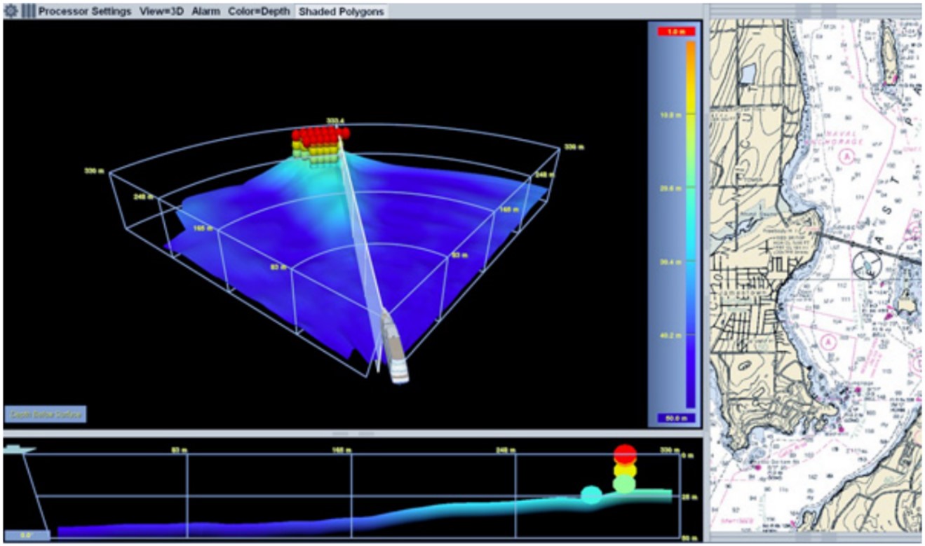
Although some passenger vessels carry forward-looking sonar systems to mitigate the risks associated with navigating in poorly surveyed waters and areas where navigation charts are unreliable, these systems are not mandatory under SOLAS, flag state, or coastal state requirements, for vessels operating in polar waters.
The Akademik Ioffe was not fitted with a forward-looking sonar system at the time of the occurrence.
1.22 National search and rescue system in Canada
After adopting the International Convention on Maritime Search and Rescue (SAR Convention) in 1979, the IMO’s Maritime Safety Committee divided the world’s oceans into 13 SAR areas. Countries within each of those areas are responsible for providing SAR resources for their specific SAR region (SRR).Footnote 167, Footnote 168
Canada’s SAR area of responsibility covers 18 million km2 of land and water, more than 243 800 km of coastline, 3 oceans, and 3 million lakes (including the Great Lakes, and the St. Lawrence River system).Footnote 169 Given this vast area, and the fact that parts of the country are characterized by varied and difficult terrain, extreme weather conditions, and low population density, Canada is regarded as one of the most difficult environments in which to conduct SAR operations.Footnote 170
The Canadian Armed Forces (CAF) is responsible for aeronautical SAR anywhere within Canada’s designated area of responsibility, and for the effective operation of the coordinated aeronautical and maritime SAR system. […] The [CCG] is responsible for maritime SAR in areas of federal responsibility (i.e. in the Great Lakes/St. Lawrence River system and coastal waters). As such, the [CCG] detects maritime incidents, works with the [CAF] in the coordination and delivery of maritime SAR response within areas of federal responsibility, provides maritime resources to assist with aeronautical SAR operations as necessary, and when and where available, provides SAR resources to assist in humanitarian incidents within provincial/territorial jurisdiction.Footnote 171
To coordinate the federal response in the aeronautical and maritime domains, the [CAF] and the [CCG] have divided Canada’s SAR area of responsibility into [3 SRRs]. Each region has a [JRCC] (located in Halifax, Trenton and Victoria) manned by officials from the [CAF] and the [CCG], who maintain around-the-clock watch, ready to coordinate a joint response to aeronautical and maritime SAR incidents [(Figure 16)].Footnote 172
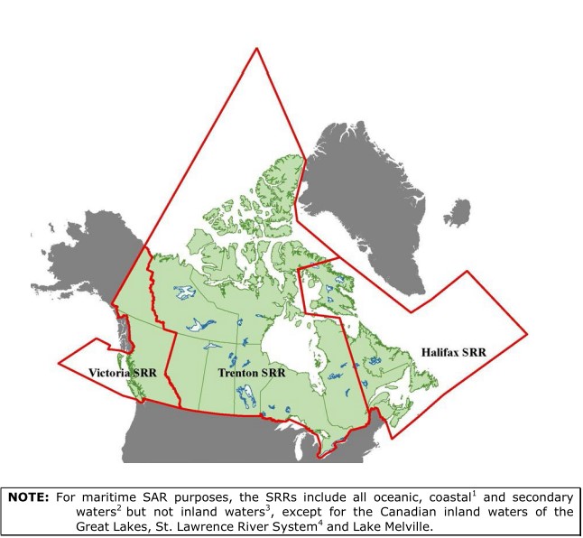
In Canada, aeronautical SAR assets are at 5 airbases, located in Gander, Greenwood, Trenton, Winnipeg, and Comox, British Columbia. In total, the CAF maintains the following fixed-wing and rotary-wing air assets:
- 14 CC-130H Hercules aircraft
- 6 CC-115 Buffalo aircraft
- 14 CH-149 Cormorant helicopters
- 5 CH-146 Griffon helicoptersFootnote 173
The CAF does not have SAR aircraft permanently stationed in the Canadian Arctic.
At the time of the occurrence, the CCG had 117 vessels and 22 helicopters stationed across the country to deliver maritime SAR services in either a primary or secondary role.Footnote 174 Although it operates an inshore rescue boat (IRB)Footnote 175 station on a seasonal basis in Rankin Inlet, Nunavut, the CCG does not have SAR vessels permanently stationed in the Canadian Arctic. However, any CCG vessel operating in the Arctic may be tasked for SAR, and two CCG vessels operating in the region were tasked to assist.
Canada’s national SAR guidelines and standard operating procedures are detailed in the Canadian Aeronautical and Maritime Search and Rescue (CAMSAR) Manual.Footnote 176 This manual supplements the International Aeronautical and Maritime Search and Rescue (IAMSAR) Manual.Footnote 177 The CAMSAR Manual describes the state of readiness for all of Canada’s primary SAR squadrons. The manual states that “SAR crews shall respond immediately to all SAR taskings and SAR aircraft shall be airborne as soon as safely possible.”Footnote 178
The maximum allowable time for a dedicated aircraft and its crew to become airborne is known as readiness posture. The CAF’s Tier 1 SAR readiness posture is 30 minutes from Monday to Friday, between the hours of 0800 and 1600. Tier 2 SAR readiness posture is 2 hours during what is known as quiet hours (outside of the hours of 0800 to 1600), weekends, and statutory holidays.
Tier 1 readiness posture normally applies to 40 hours per week; extending it beyond 40 hours per week requires approval from the commander of the First Canadian Air Division of the Royal Canadian Air Force.Footnote 179 The commander has the discretion to realign SAR readiness postures to coincide with periods of greatest SAR activity, such as the opening of specific fisheries or boating activities and events.
In 2007, 2 years after a small fishing vessel capsizedFootnote 180 with 1 confirmed fatality and 3 persons missing and presumed drowned, the Canadian National Search and Rescue Secretariat initiated a review of the CAMSAR Manual and the air SAR readiness postures. A similar review had previously been conducted in 1999. In May 2013, Canada’s Minister of Public Safety and Emergency Preparedness tasked the Secretariat with conducting quadrennial reviews of its national SAR system.Footnote 181 The inaugural review’s report was released by the Secretariat in December 2013. The report indicated that resource availability continues to be the primary factor in determining SAR response standards, which have not resulted in any change to the air SAR readiness postures. To date, no subsequent review has been conducted.
In 2018, the Standing Senate Committee on Fisheries and Oceans published the final reportFootnote 182 of its study of Canada’s maritime SAR. The study was initiated because of gaps in SAR coverage, capacity, prevention, and governance that had been identified over the past decade.
1.22.1 Major aeronautical disaster and major maritime disaster contingency plans
The CAMSAR Manual describes a major aeronautical disaster (MAJAID) as an aeronautical incident occurring in a remote area of Canada that, because of the number of people involved, requires augmentation of established SAR facilities. The Canadian Joint Operations Command Search and Rescue (CJOC SAR) staff is responsible for preparing the response to a MAJAID within Canada’s SAR area of responsibility. During a distress case with a potential or confirmed MAJAID situation, on behalf of CJOC SAR, the response will be initiated and coordinated by the JRCC responsible for the SRR where the distress occurs.Footnote 183
During a declared MAJAID situation, the responsible JRCC launches its primary SAR resources, recalls off-duty personnel to base, and prepares all serviceable aircraft for imminent launch; if necessary, the JRCC also requests additional SAR resources from the other 2 SRRs. During the implementation of the MAJAID contingency plan and regardless of the SRR in which the incident occurred, JRCC Trenton prepares an aircraft that will deploy a MAJAID sustenance kit to the site of occurrence, consisting of containers carrying food, water, tents, stoves, heaters, survival kits, first aid supplies, and other supplies for 320 survivors.Footnote 184
The CAMSAR Manual describes a major maritime disaster (MAJMAR) as a maritime distress incident or other distress incident occurring on the waters of the SRR for which the JRCC or maritime rescue sub-centre is responsible, and of such scale that the federal SAR system alone can no longer coordinate, control, and respond to all aspects of the SAR for survivors and the preservation of life. In a typical MAJMAR, the number of persons in distress is unusually large, and support from other entities operating outside of the Canadian SAR system, such as other federal agencies or civilian resources, is required. The CAMSAR Manual cites, as examples of potential MAJMAR situations, the mass evacuation of an offshore oil rig or the evacuation of a large passenger vessel’s complement. The activation protocol of the MAJMAR contingency plan is similar to the activation protocol for the MAJAID contingency plan.Footnote 185 Any SAR aircraft deploying on a MAJMAR response will also carry extra inflatable life rafts that can be launched from above the vessel in distress.
1.22.2 Search and rescue response to the Akademik Ioffe’s grounding
The Akademik Ioffe broadcast the distress message reporting its grounding at 1213 on 24 August 2018, a Friday, when all Canadian aeronautical SAR assets were operating on a Tier 1 SAR readiness posture. The CCG vessels Pierre Radisson and Amundsen were already sailing the Canadian Arctic on their annual sealift support mission, and were assigned as primary SAR units, following a 30-minute readiness posture.Footnote 186 They were tasked at 1225 and 1232 respectively. The Amundsen went underway immediately after being tasked while the Pierre Radisson went underway at 1420. The Pierre Radisson was stood down from the SAR case at 1043 on 25 August, but continued to the occurrence site to provide support to the CCG’s Environmental Response program. The Amundsen was released from the SAR case at 1458 on 25 August when the Pierre Radisson arrived on site.
Two hours following the initiation of its SAR response, as JRCC staff became concerned that the Akademik Ioffe was attempting to refloat itself and might have to be abandoned by its complement, the MAJAID contingency plan was activated. The MAJMAR contingency plan was activated 37 minutes later. Because all aeronautical SAR assets were stationed at their respective airbases in Winnipeg, Trenton, Gander, and Greenwood, multi-hour flights were forecasted and extra relief flight crews and SAR specialists were paged from their homes.
CC-130H Hercules aircraft search and rescue units (SRUs) 332-424, 333-435, and 343-413 have a maximum range of 7222 km, and the first two flew directly from their respective airbases to the occurrence site without stopping to refuel. CH-149 Cormorant helicopter SRUs 905-103 and 910-413 have a maximum range of 1018 km, and each helicopter had to refuel at different airfields along its route.
SRU 332-424 was tasked at 1255, took off at 1359 from Trenton, and arrived on scene at the site of grounding at 2021, 6 hours and 22 minutes after having departed its airbase. SRU 332-424 left the scene at 2210 and then proceeded to Rankin Inlet where it landed at 2351 for refuelling and crew resting. It took off at 1403 on 25 August and landed at 1841 in Trenton.
SRU 333-435 was tasked at 1255 on 24 August, took off at 1740 from Winnipeg, and arrived on scene at 2210, 4 hours and 30 minutes after having departed its airbase. On 25 August, at 0050, JRCC Trenton stood the aircraft down; it proceeded to Rankin Inlet for refuelling, and landed there at 0230. It took off from Rankin Inlet at 0335 to resume SAR duties, and was released from the Akademik Ioffe’s SAR case when it landed in Winnipeg at 0705.
At 1330 on 24 August, SRU 343-413 was tasked to transport relief aircrews to the Canadian Arctic; it took off from Greenwood at 1743. The aircraft landed in Gander at 2131, took off again at 2256, and landed in Iqaluit at 0248 on 25 August. It took off at 0504 from Iqaluit toward Greenwood, and was released from the SAR case when it landed at 0848 in Greenwood.
SRU 905-103 was tasked at 1345 on 24 August and took off at 1520 from Gander. It landed in Goose Bay, Newfoundland and Labrador, at 1815 for refuelling and took off again at 1902; it landed once more in Kuujjuaq, Quebec, at 2215 for refuelling, then departed at 2259 and landed in Iqaluit at 0143 on 25 August. The SRU 905-103 returned to base on 28 August.
SRU 910-413 was tasked at 1345 on 24 August and took off at 1555 from Greenwood. It landed in Sept-Îles, Quebec, at 1827 for refuelling and took off again at 1956. The aircraft landed in Kuujjuaq at 2323 for refuelling and took off again at 0008 on 25 August, landing in Iqaluit at 0258. The SRU 910-413 was released from the SAR case at 0955. The SRU 910-413 returned to base on 28 August.
JRCC Trenton declared the SAR response to the Akademik Ioffe’s occurrence closed on 29 August at 1313 (1913 UTC).
1.23 Other occurrences
On 29 August 1996, the passenger vessel Hanseatic ran aground in Simpson Strait while on passage from Gjoa Haven, Nunavut, to Resolute Bay, Nunavut.
From 2000 to 2018, 74 occurrences involving vessel grounding or bottom contact in the Canadian Arctic were reported to the TSB, including this occurrence. Six of these occurrences involved passenger vessels. Four of the occurrences involving passenger vessels took place in the Mackenzie River, Northwest Territories; the other 2 occurrences, involving the Clipper Adventurer (2010) and the Akademik Ioffe (2018), were the only occurrences within this period where passenger vessels ran aground within the Canadian Arctic Archipelago.
Additionally, on 23 August 2019, the charter yacht Hanse Explorer ran aground in Admiralty Inlet (Baffin Island) off the Peter Richards Islands, Nunavut, with 26 people on board.
Finally, several occurrences with similarities to this one have been noted in both non-Arctic Canadian and foreign waters.
A full list of previous occurrences and their summaries is available in Appendix C.
2.0 Analysis
This analysis will discuss the factors leading to the Akademik Ioffe’s grounding, as well as the vessel’s voyage planning and risk assessment, navigational watchkeeping and bridge resource management (BRM) practices, and passenger safety management practices. This analysis will also examine issues regarding charting Canadian Arctic waters, approval of Arctic voyage routing, and search and rescue resources in the Canadian Arctic.
2.1 Factors leading to the vessel’s grounding
Due to the prevailing environmental conditions at the Hecla and Fury Islands, the Akademik Ioffe deviated from its original voyage plan toward Lord Mayor Bay, west of the Astronomical Society Islands. The master was required to submit a deviation report to Transport Canada (TC), via Northern Canadian Vessel Traffic Services (NORDREG), which acknowledged and approved the requested deviation based on the area’s existing ice conditions, per its mandate.
In his assessment of the new voyage plan, the master relied on a Canadian chart but was not aware that the chart contained outdated and partial bathymetric data despite the chart indicating such. He also relied on Russian sailing directions to determine water depths along the intended route, which did not provide any specific warning about the area of the occurrence. In preparing a new voyage plan based on the Canadian chart and Russian sailing directions, the master concluded that the shallowest water depth the vessel might encounter was 50 m. Consequently, the master did not implement any additional precautions.
Because of the quarterly swell and winds, the bridge team, consisting of an officer of the watch (OOW) and a helmsman, had to navigate the Akademik Ioffe at a speed of about 8 knots for steerage. The autopilot was ineffective in those environmental conditions, and so the helmsman had to hand steer the vessel. While steering the vessel, the helmsman was no longer acting as a lookout. The OOW was therefore the sole person acting as lookout while also monitoring the bridge navigation equipment. As the vessel entered the narrows between the Ross Peninsula and the Astronomical Society Islands, extra watchkeeper(s) to assist the bridge team were not assigned nor requested, as required by the vessel’s safety management system’s (SMS) standard operating procedures (SOPs).
While transiting the narrows, the OOW was multitasking, the helmsman was busy steering the vessel, and no other crew were tasked with monitoring the echo sounders and keeping lookout. As a consequence, they did not notice the under-keel water depth steadily decrease. The master, on the bridge carrying out administrative duties, also did not notice the decrease, as the under-keel low water depth aural and visual alarms for both echo sounders were turned off. By the time the OOW noticed the decreasing water depth on the echo sounder display, it was too late for the bridge team to take evasive action, and the vessel, which had been travelling at 7.6 knots, ran aground on an uncharted rocky shoal.
The master attempted to free the vessel from the rocky shoal using the vessel’s propulsion, which aggravated damage to the hull. Subsequently, the vessel broadcast a distress call 60 minutes following the grounding.
Because of the occurrence site’s remote location, the first air search and rescue unit (SRU) arrived overhead more than 8 hours following the distress call. Because the vessel was stable and refloated with the evening tide, passengers were evacuated the next morning, once the Akademik Sergey Vavilov arrived 18 hours after the grounding. Approximately 2 hours and 31 minutes later, the Canadian Coast Guard (CCG) Amundsen arrived.
2.2 Voyage planning and risk assessment
When completing a vessel’s near coastal or deep sea passage plan, multiple guidelines and regulations apply at the coastal state, flag state, and international level. The vessel crew must also consult all available navigational information provided for all areas of the intended passage, including Notices to Shipping; Notices to Mariners; Navigational Telex; lists of lights, buoys, and fog signals; radio aids to navigation; sailing directions; and information provided by relevant navigation charts (paper or electronic format). These publications provide mariners with critical information on the hazards to navigation, which is used to assess the intended passage.
Most of the waters surrounding the Canadian Arctic Archipelago are known to be inadequately surveyed, or surveyed using outdated standards; this fact is recognized by the Canadian Hydrographic Service (CHS). Vessels transiting this area tend to sail within the main shipping corridors (known as low impact shipping corridors – LISC) as the main risk mitigation measure. Vessels that sail outside of these shipping corridors sometimes carry a forward-looking sonar system to mitigate the risk of transiting unknown waters. Although forward-looking sonar systems alone cannot guarantee a vessel’s safety in poorly charted waters, they can provide an additional tool for safe navigation. While there are clear benefits, there are also limitations, as this particular equipment requires familiarization and training to be operated, and integration with existing navigation systems.
In this occurrence, the master completed the Akademik Ioffe’s passage plan to sail the vessel toward the Astronomical Society Islands. The master used CHS chart 7502, which mentioned that the bathymetric data for the chart were of a “reconnaissance nature,”Footnote 187 collected from spot sounding surveys carried out from 1984 to 1992 at a spacing of 2000 m, and that the nature or depth of the seafloor between the soundings was unknown. The chart showed 3 points of sounding in the narrows between the Ross Peninsula and the Pearson and Astronomical Society Islands, with water depths of not less than 67 m, and the most confined point of passage between landmasses was approximately 1.5 NM with no reported shoal. The master therefore concluded that there would be enough under-keel clearance and no obstructions when the vessel transited the narrows. Consequently, the master did not implement any additional precautions.
Although there was no Notice to Shipping, Notice to Mariners, or Navigational Telex for the area at the time of the occurrence, the crew had sufficient information on hand to establish that the waters in the narrows were largely unknown and to suspect that the water depths cited on the chart did not accurately reflect the actual depths throughout the entire narrows. None of the Akademik Ioffe’s crew had sailed the area before, so extra precautions likely would have helped to perform a safe transit and to manage unpredictable navigational hazards.
In such a situation, general good seamanship practices would dictate:
- tasking additional watchkeepers to support the OOW in navigating the vessel and monitoring the navigation equipment, such as the echo sounders;
- setting the aural under-keel low water depth alarm to 50 m on both echo sounders;
- waiting for improved environmental conditions before proceeding in the narrows, in accordance with the IMO’s Resolution A.893(21) on voyage planning, which recommends to maintain safe speed while sailing in proximity of potential navigational hazards;
- with favourable environmental conditions, maintaining a steerage speed lower than about 8 knots to allow the bridge team more time to create a mental model of the decreasing under-keel clearance, and take the necessary evasive actions such as slowing, stopping, or turning around the vessel;
- taking into account the limitations of the bathymetry on the chart and assuming the information might be unreliable; and
- considering an alternate passage, although longer in both distance and time of transit. Another route around the north of the Astronomical Society Islands was available, with deeper water depths, wider passage, and no reported shoal.
The crew navigated the Akademik Ioffe to destinations selected by One Ocean Expeditions’ on-board representative, the expedition leader. The expedition leader had authority to request adjustments to the vessel’s itinerary depending on the prevailing conditions, to optimize passenger experience. As a result, the expedition leader had multiple informal contingency plans for alternate destinations, should an itinerary become impracticable, and made real-time adjustments in cooperation with the master.
The nature of the commercial relationship between a vessel owner and charterer may have influenced the master to follow the charterer’s recommendations for the proposed new itinerary. The fact that the vessel was engaged in a high cost, luxury expedition cruise may have added to that pressure.
Because prevailing conditions were unpredictable, the vessel itinerary could also change quickly, and the master had to assess the feasibility of any new passage plan within a very limited timeframe. However, he had more than 3 hours to consider how he would execute the plan, including transiting a narrow passage in an area he had not been before. In this occurrence, the master decided to sail the vessel in an inadequately surveyed area without mitigating measures, such as posting additional watchkeepers to support the bridge team.
If a vessel’s crew conducts passage planning and assessment based on incomplete and unreliable navigational data without taking mitigating measures, there is an increased risk to the safety of the vessel and its complement.
2.3 Navigational watchkeeping
In open sea, under normal environmental and traffic conditions, a vessel like the Akademik Ioffe can be navigated by a bridge team consisting of an OOW and a helmsman; it is reasonable to assume that 2 persons would be sufficient to efficiently monitor and operate all navigation equipment while maintaining a lookout. However, in accordance with good seamanship, industry guidelines,Footnote 188 and the IO RAS’s standard operating procedures, when a vessel transits confined waters such as the narrows between the Ross Peninsula and the Astronomical Society Islands, the vessel’s bridge team must be supported by additional watchkeeper(s) as deemed necessary.
In this occurrence, even after the Akademik Ioffe had entered the narrows between the Ross Peninsula and the Astronomical Society Islands, the OOW did not request extra watchkeeper(s) to support the bridge team in looking out and monitoring the navigation equipment, and the master did not assign any. With quartering winds and swells that required a speed of about 8 knots to maintain steerage, the helmsman was ordered to hand steer the vessel and the OOW was the sole navigator and lookout. As such, the OOW was the single person performing the bridge watch duties and had to multitask, focusing on each piece of navigation equipment for a limited amount of time, and he was not able to continuously monitor information received by the vessel’s 2 echo sounders.
Mandatory navigation equipment such as echo sounders are fitted with adjustable aural alarms so that critical data, like low under-keel water depth, will not go unnoticed by the bridge team. The bridge watch officers and ratings on board the Akademik Ioffe found the aural alarms to be a nuisance, and so the alarms had intentionally been turned off on both echo sounders; they remained turned off at all times and on all watches, including at the time of the occurrence. As a result, critical notifications were removed from the feedback loop of information that was available to the OOW when navigating.
Without continuously monitoring the vessel’s 2 echo sounders, and without active aural alarms, the OOW had no warning of the gradually decreasing under-keel water depth, and was not aware of it until 35 seconds before the vessel grounded.
As the vessel sailed, the under-keel water depth decreased from 100 m to 50 m within 2 minutes and 30 seconds, and it took an additional 1 minute and 34 seconds for the vessel to run aground. Had an aural low water depth alarm been set at 50 m on either of the 2 echo sounders, which was the minimal under-keel clearance to be encountered per the passage plan, the OOW would have had 1 minute and 34 seconds to take evasive action to avoid striking the rocky shoal. Instead, by the time the OOW looked at one of the echo sounders, he only had 35 seconds to confirm the information received, build a mental model of the incoming hazard, and initiate evasive action, before the vessel ran aground.
Because the new passage plan had been approved by both the master and TC, bridge team members may have assumed that the vessel’s track was along a safe corridor, resulting in reduced vigilance while navigating the vessel.
Prior to the grounding, the vessel was being navigated in daylight, with a visibility of 5 NM, and with primary reference to an electronic navigational chart (ENC) displayed on the bridge’s electronic chart display and information systems (ECDIS). The OOW had received mandatory ECDIS training and was proficient in its use.
Another factor that contributed to the OOW’s false sense of having enough sea room was that the ENC’s scale was reduced to 1:250 on the ECDIS, compared to the corresponding paper chart at a scale of 1:500 000. This reduced scale made it look as though the vessel was transiting a larger coastal inlet, free of nearby obstacles and far from opposing shores, rather than narrows with multiple immerged shoals and submerged rocks in the vicinity. The significant zoom-in displayed on the ENC compromised the OOW’s ability to comprehend the risks of the shallowing seafloor in time to take effective action.
Since the introduction of electronic charts, air and marine transportation modes have experienced an increase in incidents involving those charts and their zoom functions, which can inadvertently exclude critical information and impact an operator’s expectations of their position in an operating space.
If bridge navigation equipment is not optimally operated and automatic safety features such as alarms are turned off, there is a risk that a bridge team will miss critical information, especially in situations where the prevailing navigating conditions create a high workload for bridge team members.
Also, if the bridge team composition is inadequate during periods of high workload, such as when transiting confined waters, there is a risk that critical navigational parameters, such as the under-keel water depth, will not be properly monitored, compromising vessel safety.
2.4 Passenger safety
2.4.1 Safety familiarization of passengers
According to the International Convention for the Safety of Life at Sea, 1974 (SOLAS), newly-embarked passengers must undergo safety briefings and musters before or immediately upon vessel departure. Before 2015, passenger safety briefings and musters could take place within 24 hours of passenger embarkation; following the 2012 Costa Concordia occurrence, the SOLAS Convention was amended to require passenger briefings and musters prior to or immediately upon departure. The Akademik Ioffe’s passenger safety checklist had not been amended since 2015, and did not reflect the latest SOLAS requirements.
The master postponed the mandatory pre-departure muster drill and safety briefing because passengers and the expedition leader were fatigued by their long journey from their various countries of origin to the vessel in Kugaaruk, Nunavut. Instead of being briefed on the donning of lifejackets, emergency sounds and signals, escape routes, muster stations, and the boarding of lifeboats, the passengers were briefed on topics such as seasickness, shipboard hazards, doorways, ladders and staircases, and basic sanitation. Although the Akademik Ioffe’s passenger safety checklist indicated that passengers and expedition staff had been briefed and had mustered by 2030 on 23 August 2018 just after they boarded the vessel, the investigation determined that the muster and safety briefing were actually carried out the following morning, after having been underway for 12 hours following embarkation and contrary to SOLAS requirements.
Had an emergency occurred on board while the vessel was at sea the night before the grounding, none of the passengers would have been familiar with donning a lifejacket, the location of the vessel’s escape routes, emergency exits, muster stations, and with boarding the lifeboats.
If passengers are not familiarized with shipboard lifesaving appliances upon their embarkation and before the vessel proceeds to sea, there is a risk they will not be able to respond appropriately to an emergency situation, should the need arise early in the voyage.
The crew was responsible for the day-to-day vessel safety and onboard regulatory compliance, including delivering pre-departure safety briefings to passengers. However, on board the Akademik Ioffe, the expedition staff were informally tasked to coordinate passenger safety during the voyage, and provided the safety briefing to passengers on behalf of the vessel’s crew.
Expedition staff developed safety materials and training for passengers on board the Akademik Ioffe, based on their own appreciation and perspective of the safety topics pertinent to passenger safety, and these safety materials were not controlled by the vessel’s crew or shore management. Their knowledge and experience notwithstanding, expedition staff are not licensed marine personnel; they may not have knowledge of marine and ship-specific processes and procedures, nor be familiar with the functions and limitations of a vessel’s safety systems. Without a documented understanding between the vessel’s senior officers and the expedition staff for the delivery of the safety program, opportunities to enhance emergency preparedness such as communication strategies and expectations for passenger coordination were missed.
The developed passenger safety briefings varied depending on the expedition staff member providing them, and the information disseminated through the briefings equally varied. The topics covered during the briefings were seasickness, on-board hygiene, the SOLAS lifejacket, medical emergencies, doorways, stairs, tripping hazards, handwashing, gangways, zodiacs, and seal and polar bear safety.
The investigation revealed that SOLAS-mandatory topics such as fire safety and lifesaving were inconsistently instructed. Moreover, some passengers were unable to hear expedition staff as they delivered the verbal safety briefing on the outside deck by the lifeboat, because of wind noise. The expedition staff did not confirm that all the information presented in the briefing was clearly understood by all passengers, further supporting the lack of consistency in the manner of disseminating critical safety information to the passengers.
If passenger safety briefings and familiarizations are planned and delivered by uncertified staff rather than qualified crew members, there is risk that lapses in this critical familiarization will occur and impede passenger readiness in an emergency.
2.4.2 Emergency management and contingency procedures
A decision support system (DSS) is a SOLAS-required safety tool for passenger vessels, proven to provide a quick single point of reference for vessel masters to manage any foreseeable shipboard emergency, or combination of simultaneous shipboard emergencies.
The DSS on board the Akademik Ioffe did not include emergency procedures for the vessel touching bottom or running aground. However, the vessel’s SMS did include a post-grounding checklist that was used by the crew in this occurrence. During the occurrence, the master had to search the vessel’s checklist catalogue to find and follow this particular checklist, rather than simply referring to the more accessible DSS. The investigation could not determine whether this time lapse negatively affected the timeliness and efficiency of the response following the grounding.
If critical safety tools such as emergency procedures and decision support systems are not optimized for use by the crew in an emergency or simultaneous emergencies, there is a risk that their response will be uncoordinated.
Following a grounding, attempts to refloat a vessel using propulsion should only be made if the vessel is in immediate danger of sustaining a catastrophic structural failure, or of worsening the hull breaches. Otherwise, attempting to refloat a vessel using propulsion can (further) damage a vessel’s structure, and the vessel might capsize or sink once it is not supported by the object on which it grounded. By specifying that the master must attempt to refloat the vessel using propulsion, the Akademik Ioffe’s post-grounding checklist did not follow recognized seamanship practices for responding to a vessel grounding. However, the post-grounding checklist prescribed and detailed initial emergency actions to be taken before attempting to refloat the vessel, such as activating the general alarm, ordering the immediate mustering of everyone on board, and broadcasting a distress message using the vessel’s Global Maritime Distress and Safety System (GMDSS). These actions are in line with industry standards.
In this occurrence, the master attempted to refloat the vessel from the rocky shoal using the vessel’s propulsion immediately after it grounded, rather than following the initial emergency actions prescribed in the checklist. Although these actions were in accordance with the vessel’s SOPs, they went against good seamanship and industry standards, which first require proper vessel stability and hull integrity assessments. Given the loud noises and strong vibrations experienced by all persons on board as the master used propulsion to try to free the Akademik Ioffe from the shoal, the master’s attempts further damaged the vessel’s shell plating and structure.
Moreover, had the master’s refloat attempt been successful, the vessel might have capsized or sank as it left the support of the rocky shoal. By attempting to free the vessel immediately after the grounding rather than assessing the stability and hull integrity, the master unwittingly put the safety of the vessel and its complement at risk. Furthermore, no attempt was made to prevent the vessel from self-refloating with the flooding tide during the following hours.
In this occurrence, the master’s decision to not activate the general alarm could have delayed and impaired an orderly evacuation of the passengers, should the vessel have capsized or sank, since none of the passengers had mustered, properly dressed for cold weather, and donned their lifejacket when the master tried to refloat the vessel. Preparing passengers to abandon the vessel takes several minutes, and this procedure must be initiated as soon as an incident that may warrant an abandonment occurs.
In an emergency, providing passengers with concise and reliable information, along with clear and simple instructions, allows them to build a mental model of the situation. Communicating with passengers in this way also builds their resilience, and prepares them to respond to the emergency. Although some passengers may freeze or panic when briefed on an emergency, most will be reassured that the crew has the situation under control and that an adequate response is being organized. Passengers who are confident in this regard are more likely to follow crew instructions. In this occurrence, efforts to free the vessel from the shoal took precedence over preparations for a possible evacuation.
The master did not want to cause panic among the passengers and therefore refrained from activating the general alarm. Instead, he used the public address (PA) system to order the crew to prepare the lifeboats for an eventual abandonment, addressing them in Russian rather than English in order not to alarm the passengers. It was the master’s understanding that the only situations requiring passengers to muster were a fire or imminent sinking of the vessel. Withholding information from passengers, especially in situations where they receive cues from crew that something is wrong, can create anxiety, stress, and may even prompt some passengers to act irrationally in an attempt to ensure their own safety.
When the Akademik Ioffe ran aground, passengers felt the vessel abruptly stop, vibrate, and suddenly heel to starboard. They also witnessed water contaminated with oil being pumped overboard, and increased activity among the crew as some crew members donned lifejackets and prepared the vessel’s lifesaving appliances. Withholding information and clear instructions confused and stressed passengers, rather than reassured them. Without a shared mental model, passengers had differing perceptions of, and reactions to, the occurrence. In an effort to learn more about the situation and reassure passengers, the expedition leader visited the bridge to confer with the master, and eventually the expedition leader requested permission from the master to directly inform the passengers of the situation in English, as passengers had become more worried and anxious over time.
The expedition leader received permission from the master to address passengers in English over the PA system. In his address, he unknowingly relayed incorrect information by saying that the hull was not breached, and then asking passengers to remain as they were and await further instructions. The expedition leader’s second announcement, made 17 minutes following the grounding, informed passengers that the vessel had grounded, that the hull had not been breached, and that the master would use the vessel’s thrusters to free the vessel. The expedition leader again asked passengers to await further information rather than asking them to dress with warm clothing and to muster.
In a marine emergency requiring outside assistance, such as environmental response, towage, MEDEVAC, recovery of survivors, firefighting, etc., broadcasting a distress message as soon as feasible is key to ensuring that search and rescue (SAR) assets and pertinent stakeholders (vessel owners, port and flag state authorities, etc.) are advised early so they can activate their specific response protocols. In this occurrence, the vessel’s distress call using the GMDSS was broadcast 60 minutes following the grounding, delaying by 1 hour the SAR response by Canadian authorities.
Some specific human factors can help explain the master’s rationale behind his response to the grounding of the Akademik Ioffe. The occurrence voyage was part of the master’s first contract where he commanded a vessel. With a complement of 163 persons, it was also the master’s first time working with the expedition leader to conduct a voyage that required major revisions to the passage plan, departing from a secondary port, and having embarked passengers late in the day, all of which drove the need to delay safety drills. As a representative of the IO RAS, the master was entirely responsible for the safe navigation of the vessel, as well as overseeing every onshore passenger excursion.
Given the master’s level of experience, his responsibilities regarding safety and passenger experience, the expensive fare passengers were paying to experience this expedition cruise and the expectations passengers may have had as a result, the master likely considered the negative effect that the vessel’s grounding (on the first full day of the voyage) would have on his reputation and that of the IO RAS and One Ocean Expeditions.
Cultural factors also played a role in the events immediately following the grounding. The power distance principle refers to the level of comfort some cultures have in working within systems where leadership is rarely questioned or challenged; this principle plays out in the fact that the bridge team did not question or challenge the SOPs and the master’s decisions and actions. The master’s urgency and determination to refloat the vessel illustrate the principle of local rationality. From a human performance perspective, the master’s efforts after the grounding were most likely reactive problem solving based on inexperience rather than a lapse in skills.
If proper post-occurrence contingency actions are not taken in an emergency situation, there is a risk of adverse consequences affecting the seaworthiness of the vessel or the safety of its passengers and crew.
If passengers are not given concise information and clear instructions during a shipboard emergency, there is a risk that passengers will become confused and react in an uncoordinated manner, delaying an orderly evacuation and compromising their safety.
2.5 Operating in Canadian Arctic waters
2.5.1 Charting Canadian Arctic waters
The CHS is responsible for ensuring that Canada meets its international obligations under the SOLAS Convention to provide hydrographic services supporting safe navigation as well as adequate and up-to-date charts and publications for all ships navigating in Canadian inland and coastal waters, including the Canadian Arctic. The Canadian Arctic’s remoteness, harsh winters, adverse ice conditions, short navigational season, and historically low marine traffic density contribute to the level of resources the CHS has put in place to produce reliable navigation charts covering these waters. By 2014, less than 25% of the Canadian Arctic paper charts were rated “good” by the CHS. By 2019, about 14% of Canadian Arctic waters had been surveyed to modern or adequate standards.
Mariners who are experienced at sailing Canadian Arctic waters know to stay within the main shipping corridors, where reported water depths are reliable. The 2008 near-grounding of the Akademik Ioffe (Appendix C), the 2010 grounding of the Clipper Adventurer (Appendix C), the 2019 grounding of the Hanse Explorer (Appendix C), and this occurrence have demonstrated that vessel tracks based on spot soundings can be unreliable, as the actual water depths and seafloor topography between soundings are unknown.
On charts produced with reconnaissance data, the CHS notes that the shape of the seafloor between the depths measured by spot soundings is unknown. In addition, when the portrayal of the seafloor is based on vessel tracks, the CHS notes that the accuracy is uncertain and no information about depths on either side of the track is available. However, as this occurrence demonstrates, some mariners continue to operate as if the seafloor around a charted spot sounding or vessel track has been surveyed. This could be mitigated by more prominent indications on charts of the limitations of the bathymetric data.
Based on the information provided by chart 7502, which illustrates the spot soundings throughout the narrows between the Ross Peninsula and the Astronomical Society Islands, the master noted in the vessel’s revised passage plan that the shallowest waters the vessel might encounter would be 50 m. This indicates that the master was under the impression that waters throughout the narrows had been adequately surveyed, and that the absence of any shoal verified the safety of the intended track.
As marine traffic increases in the Canadian Arctic, the number of marine occurrences will likely also increase. The CHS is aware that it needs to address the issues of partial and missing bathymetric data; it is currently developing new approaches to gather hydrographic data that will allow it to produce charts that are updated to modern standards. Technologies like satellite-derived imagery could accelerate the process of identifying navigational hazards such as shoals, since the shoal on which the Akademik Ioffe grounded was successfully spotted using this technology (Appendix B). Satellite-derived imagery is still in development and its reliability is limited under certain conditions. As such, it has not yet been fully integrated into the CHS’s standard operations.
Currently, the CHS conducts surveys in the Canadian Arctic mainly based on opportunity, meaning that it does not own or operate vessels permanently assigned to collect bathymetric data in these waters. Instead, the CHS uses so-called vessels of opportunity, which are mostly owned by other federal agencies and departments, and operate in the region to fulfill other mandates; these vessels expend limited time and effort in gathering data for the CHS.
In 2014, the Office of the Auditor General of Canada identified this lack of reliable bathymetric data as a major lapse in marine safety. There have been improvements since this time, with the overall surveyed area of the Canadian Arctic to modern or adequate hydrographic standards having increased by 13% from 2014 to 2019. The CHS plans to chart the Canadian Arctic to modern hydrographic standards using CCG vessels retrofitted with modern hydrographic sonars; given that these are vessels of opportunity, it is unlikely that all areas of the Canadian Arctic will be surveyed in the short term. Currently, the CHS does not have a timetable to complete a thorough coverage of these waters that would comply with modern international hydrographic standards.
If the coastal waters surrounding the Canadian Arctic Archipelago are not surveyed to modern international hydrographic standards and the existing government-issued navigation charts are based on incomplete bathymetric data, there is a risk that mariners will not have adequate information to safely navigate in these waters.
The risks associated with unreliable navigation charts for the waters surrounding the Canadian Arctic Archipelago are ongoing and will remain for some time, and so it is important that proper mitigation measures be implemented for the safety of vessels operating in this area.
For instance, the Canadian port and flag state authority, TC, could, in addition to following the guidance in the Paris/Tokyo Memorandums of Understanding on Port State Control (MoUs) and in its national statutory inspection program, systematically conduct more detailed Port State Control (PSC) inspections on foreign-flagged vessels and more detailed flag state monitoring inspections on domestic vessels intending to enter the NORDREG zone. A more detailed inspection, either under the PSC or flag state monitoring regime, normally includes an in-depth audit of the vessel’s SOPs and function checks of various shipboard systems and equipment; such an inspection should normally have allowed the inspector to notice the Akademik Ioffe’s deficient DSS and its deficient post-grounding checklist, and to observe that its voyage plan was not in accordance with the IMO Resolution A.893(21). A more detailed inspection would have also allowed the inspector to perform functional testing on the bridge equipment; finding that the low water depth alarms were intentionally turned off on both echo sounders might have raised further questioning and scrutiny with regard to the vessel’s bridge procedures and the crew’s navigational practices, including the use of the ECDIS.
The Akademik Ioffe underwent a more detailed PSC inspection upon berthing in its first Canadian port, before it proceeded to the Canadian Arctic Archipelago, and TC had the opportunity to note the above-mentioned deficiencies and require them to be rectified before the vessel proceeded on its intended voyage. However, the attending Port State Control Officer did not note any of the deficiencies.
A forward-looking sonar system is an efficient tool to help vessels safely transit poorly surveyed waters, where navigation charts are considered to be unreliable. As some systems provide the bridge team with a three-dimensional view of both the seafloor and any in-water obstacles up to 1000 m ahead of the vessel’s bow, some passenger vessels operating in polar waters are fitted with such systems, although their carriage is not mandatory under current national and international requirements. The use of such systems combined with other navigation equipment can provide bridge teams with a warning as to a shoal or underwater hazard ahead when being actively monitored.
Until the coastal waters surrounding the Canadian Arctic Archipelago are adequately charted, and if alternate mitigation measures are not put in place, there is a persistent risk that vessels will make unforeseen contact with the sea bottom.
2.5.2 Marine traffic regulation in Northern Canada
NORDREG provides mariners with information about ice conditions and recommended routes, and can arrange for icebreaking assistance and SAR. Vessels sailing Canadian Arctic waters must submit their itineraries to NORDREG, which are then vetted by TC to determine that their ice class is sufficient against the prevailing ice conditions along the intended passage. Neither TC nor NORDREG assesses the safety or feasibility of a vessel’s passage plan against any potential hazards along the intended route.
Following the TSB investigation into the grounding of the Clipper Adventurer, NORDREG changed its work procedures. After transferring the passage plans submitted by a vessel to TC for vetting, and when responding to that vessel, NORDREG now provides any national Navigational Warning (NAVWARN) that is active for the area(s) in which the vessel intends to proceed. In this occurrence, TC did not assess the Akademik Ioffe’s passage plan for potential navigational hazards along its intended route. Since no NAVWARN was active for the region (Gulf of Boothia), NORDREG did not provide any warning to the Akademik Ioffe when it transferred TC’s clearance to proceed with the vessel’s new passage plan.
Although not within its current mandate, had NORDREG crosschecked the passage plan that the Akademik Ioffe submitted to NORDREG against the applicable navigation chart (CHS chart 7502), it would have been noted that the vessel’s itinerary and destination were located in waters not surveyed to adequate standards.
A vessel’s crew is ultimately responsible for consulting relevant navigational publications and noting any warnings. However, since most hydrographic data for Canadian Arctic waters are unreliable, having NORDREG remind the crews of all foreign-flagged and domestic vessels entering poorly surveyed areas to be careful in trusting the reported water depths and apparent absence of navigational hazards, could be a mitigation measure.
If the mandate of a vessel traffic coordinating and controlling organization does not include warning vessels to use extreme caution as they sail into poorly surveyed waters, there is a risk that crews will miss critical warnings from the official navigational publications, compromising the safety of their vessels and complements.
2.5.3 Search and rescue coverage for the Canadian Arctic
Coastal states are responsible for providing effective SAR to vessels in distress within their search and rescue regions (SRRs). In Canada, this responsibility is shared by the Canadian Armed Forces (CAF) and the CCG. While aeronautical assets are operated by the CAF and maritime assets are operated by the CCG, SAR interventions are jointly managed by both organizations in 3 joint rescue coordination centres (JRCCs).
In this occurrence, the JRCC in Trenton, Ontario, was responsible for managing the SAR response to the Akademik Ioffe’s grounding, as the grounding occurred within JRCC Trenton’s SRR. The SAR response was initiated as soon as JRCC Trenton received the vessel’s digital selective calling (DSC) distress message. Two foreign SAR organizations also received the DSC message and immediately forwarded it to Canadian authorities, demonstrating the effectiveness of the global SAR system.
Within minutes of initiating its SAR response, JRCC Trenton tasked multiple aeronautical and maritime assets to deploy to the occurrence site. The closest CCG vessel was 19 hours and 26 minutes away from the Akademik Ioffe’s position, so the closest vessel available to assist was the sister vessel Akademik Sergey Vavilov. The Akademik Sergey Vavilov’s passengers were ashore on an excursion and the vessel could not get underway before all passengers returned on board.
As there were initial concerns that the Akademik Ioffe was attempting to refloat itself and might have to be abandoned by its complement, the JRCC activated its major air disaster and major marine disaster contingency plans. Activating these contingency plans results in some logistical delays, as the equipment must first be retrieved from storage and then loaded onto the aircraft being deployed. Because all aeronautical SAR assets were stationed at their respective airbases in Winnipeg, Manitoba; Trenton; Gander, Newfoundland and Labrador; and Greenwood, Nova Scotia, multi-hour flights were forecasted. Extra relief flight crews and SAR specialists had to be recalled to their airbases. Additionally, both CH-149 Cormorant helicopters tasked to deploy on site had to stop multiple times to refuel; however they were subsequently stood down.
The first SAR aircraft arrived on scene 8 hours following the Akademik Ioffe’s distress call; it provided top coverage, by circling above the vessel and standing by for launching equipment and SAR specialists, if needed. While the first commercial SRU (Akademik Sergey Vavilov) arrived on scene 17 hours and 4 minutes following the distress call, the first CCG SRU with retrieval capability arrived on scene 19 hours and 45 minutes following the distress call. Had the Akademik Ioffe’s 163 crew, expedition staff, and passengers needed to evacuate after its grounding, they would have had to stay on the nearby shores or in the vessel’s lifesaving appliances for 18 hours after the grounding, in near-freezing air temperatures, with a daytime wind chill of −5°C.
The CAF and CCG do not permanently maintain SAR assets in the Canadian Arctic, and a limited number of CCG vessels are deployed to cover large areas during the peak season of marine traffic in this region. As demonstrated by the 2010 grounding of the Clipper Adventurer, where the passengers could only be evacuated 2 days following the occurrence, and in this occurrence, where 18 hours elapsed before the first vessel arrived, the lack of SAR resources deployed in the Canadian Arctic creates delays in providing assistance in the event of a marine occurrence in this area.
This is of particular importance knowing that the Canadian Arctic is a harsh and remote area of the country, with prevailing low air temperatures; hypothermia can affect survivors of a vessel abandonment within minutes of being exposed to the outside environment, making survival a challenge for crews and passengers.
Given the increasing volume of vessel traffic in the Canadian Arctic, if search and rescue resources are not able to provide assistance to a marine occurrence in a timely manner, there is an increased risk of adverse consequences to vessels, their complements, and the environment.
3.0 Findings
3.1 Findings as to causes and contributing factors
These are conditions, acts or safety deficiencies that were found to have caused or contributed to this occurrence.
- Due to the prevailing environmental conditions at the Hecla and Fury Islands, the Akademik Ioffe deviated from its original voyage plan toward Lord Mayor Bay, west of the Astronomical Society Islands.
- In his assessment of the new voyage plan, the master relied on a Canadian chart but was not aware that the chart contained outdated and partial bathymetric data despite the chart indicating such.
- In preparing a new voyage plan based on the Canadian chart and Russian sailing directions, the master concluded that the shallowest water depth the vessel might encounter was 50 m. Consequently, the master did not implement any additional precautions.
- While transiting the narrows, the officer of the watch was multitasking, the helmsman was busy steering the vessel, and no other crew were tasked with monitoring the echo sounders and keeping lookout. As a consequence, they did not notice the under-keel water depth steadily decrease.
- The under-keel low water depth aural and visual alarms for both echo sounders were turned off.
- By the time the officer of the watch noticed the decreasing water depth on the echo sounder display, it was too late for the bridge team to take evasive action, and the vessel, which had been travelling at 7.6 knots, ran aground on an uncharted rocky shoal.
- The master attempted to free the vessel from the rocky shoal using the vessel’s propulsion, which aggravated damage to the hull.
3.2 Findings as to risk
These are conditions, unsafe acts or safety deficiencies that were found not to be a factor in this occurrence but could have adverse consequences in future occurrences.
- If a vessel’s crew conducts passage planning and assessment based on incomplete and unreliable navigational data without taking mitigating measures, there is an increased risk to the safety of the vessel and its complement.
- If bridge navigation equipment is not optimally operated and automatic safety features such as alarms are turned off, there is a risk that a bridge team will miss critical information, especially in situations where the prevailing navigating conditions create a high workload for bridge team members.
- If the bridge team composition is inadequate during periods of high workload, such as when transiting confined waters, there is a risk that critical navigational parameters, such as the under-keel water depth, will not be properly monitored, compromising vessel safety.
- If passengers are not familiarized with shipboard lifesaving appliances upon their embarkation and before the vessel proceeds to sea, there is a risk they will not be able to respond appropriately to an emergency situation, should the need arise early in the voyage.
- If passenger safety briefings and familiarizations are planned and delivered by uncertified staff rather than qualified crew members, there is risk that lapses in this critical familiarization will occur and impede passenger readiness in an emergency.
- If critical safety tools such as emergency procedures and decision support systems are not optimized for use by the crew in an emergency or simultaneous emergencies, there is a risk that their response will be uncoordinated.
- If proper post-occurrence contingency actions are not taken in an emergency situation, there is a risk of adverse consequences affecting the seaworthiness of the vessel or the safety of its passengers and crew.
- If passengers are not given concise information and clear instructions during a shipboard emergency, there is a risk that passengers will become confused and react in an uncoordinated manner, delaying an orderly evacuation and compromising their safety.
- If the coastal waters surrounding the Canadian Arctic Archipelago are not surveyed to modern international hydrographic standards and the existing government-issued navigation charts are based on incomplete bathymetric data, there is a risk that mariners will not have adequate information to safely navigate in these waters.
- Until the coastal waters surrounding the Canadian Arctic Archipelago are adequately charted, and if alternate mitigation measures are not put in place, there is a persistent risk that vessels will make unforeseen contact with the sea bottom.
- If the mandate of a vessel traffic coordinating and controlling organization does not include warning vessels to use extreme caution as they sail into poorly surveyed waters, there is a risk that crews will miss critical warnings from the official navigational publications, compromising the safety of their vessels and complements.
- Given the increasing volume of vessel traffic in the Canadian Arctic, if search and rescue resources are not able to provide assistance to a marine occurrence in a timely manner, there is an increased risk of adverse consequences to vessels, their complements, and the environment.
3.3 Other findings
These items could enhance safety, resolve an issue of controversy, or provide a data point for future safety studies.
- The master of the Akademik Ioffe did not wait for a Canadian Coast Guard vessel to arrive before evacuating the vessel. Although not enough lifesaving appliances were available on the Akademik Sergey Vavilov for the combined complements of both vessels, the Joint Rescue Coordination Centre and Transport Canada agreed to the evacuation plan.
- At 0912, the Akademik Sergey Vavilov departed the occurrence site for Kugaaruk with the passengers from the Akademik Ioffe on board, after having been granted an exemption from Transport Canada to sail with 100 persons more than the vessel’s lifesaving equipment capacity.
- The 4 certified bridge watch officers on board the Akademik Ioffe had completed and signed the P.P. Shirshov Institute of Oceanology of Russian Academy of Sciences’ familiarization checklist for shipboard bridge equipment. The equipment familiarization checklist on board the Akademik Ioffe included the use of the echo sounders but did not include the electronic chart display and information systems.
- An Arctic Pollution Prevention Certificate was issued to the vessel, although it was not required. The certificate stated that the vessel was carrying the most recent editions of the Canadian Sailing Directions, the Canadian Notices to Mariners, and the Ice Navigation in Canadian Waters, despite the fact that the most recent editions of these publications were not on board the vessel at the time the certificate was issued.
- The Akademik Ioffe initiated its expedition cruise from a Canadian location (Kugaaruk, Nunavut) not listed in the letter of compliance for its coasting trade licence.
- The minimum and maximum operating draughts prescribed in the Arctic Pollution Prevention Certificate differed from those stated on the vessel’s Polar Ship Certificate.
- The Akademik Ioffe’s shipboard post-grounding checklist required the master to attempt refloating the vessel after mustering the entire complement, but before carrying out a damage assessment that included the integrity of the hull and its appendages.
- It is within Transport Canada’s mandate to assess a vessel’s ice navigation capabilities against existing ice conditions. The Northern Canada Vessel Traffic Services serves as a communication intermediary between the vessel and Transport Canada for the information exchange; Northern Canada Vessel Traffic Services does not have the mandate, expertise, or regulatory authority to assess the safety of a vessel’s intended passage for hazards.
- Although they were included in the Akademik Ioffe’s safety management system, procedures for responding to a grounding or flooding or for evacuating the crew, expedition staff, and passengers were not included in the decision support system.
- Contrary to the International Convention for the Safety of Life at Sea, 1974 requirements, the lifeboat mustering and ship safety briefing were carried out more than 12 hours after the vessel’s departure to sea from its anchorage off Kugaaruk.
- The investigation determined that the passenger safety checklist had not been updated to reflect the 2015 amendment to the International Convention for the Safety of Life at Sea, 1974, which requires specific tasks to be conducted prior to or immediately upon vessel departure.
- The first Port State Control inspection, conducted by Transport Canada in Louisbourg, Nova Scotia, did not identify any of the 12 deficiencies noted during the post-occurrence Port State Control inspection 37 days later while the Akademik Ioffe was at anchorage off the Astronomical Society Islands.
- Although some passenger vessels carry forward-looking sonar systems to mitigate the risks associated with navigating in poorly surveyed waters and areas where navigation charts are unreliable, these systems are not mandatory under the International Convention for the Safety of Life at Sea, 1974, flag state, or coastal state requirements, for vessels operating in polar waters.
4.0 Safety action
4.1 Safety action taken
4.1.1 Transport Canada
Following the occurrence, Transport Canada issued a Letter of Warning to the Authorized Representative (AR) of the Akademik Ioffe, requiring that all deficiencies be addressed and a corrective action plan issued. It was also communicated that any future non-compliance would result in greater enforcement actions. Transport Canada then received a letter from the AR of the Akademik Ioffe, indicating that all deficiencies had been corrected.
4.1.2 Canadian Hydrographic Service
Following the occurrence, the Canadian Hydrographic Service amended navigation chart 7502: Northwest Territories – Gulf of Boothia and/et Committee Bay, via a Notice to Mariners (12 October 2018) to include the rocky shoal on which the Akademik Ioffe ran aground, at position 69°43.00′ N, 091°21.00′ W. The amended chart indicates “rep 2018” Footnote 189 and a depth of 5.2 m.
4.1.3 Russian Federation
Following the occurrence, the Russian Federal Authority for Transport Oversight (Rostransnadzor) carried out a safety investigation and produced a marine casualty investigation report. The report identified poor and unreliable charting in the area the Akademik Ioffe sailed as the cause of the grounding. The report recommended that mariners increase watchkeeping with more bridge watch personnel and more lookouts when sailing in confined waters, use a forward-looking sonar system, maintain minimal safety speed to keep steerage of the vessel, and use anchors as a dip line to navigate unknown waters. Finally, Rostransnadzor recommended to the P.P. Shirshov Institute of Oceanology of Russian Academy of Sciences that the Akademik Ioffe’s crew be made aware of the investigation’s conclusions, and that it establish procedures to prevent a recurrence.
4.1.4 P.P. Shirshov Institute of Oceanology of Russian Academy of Sciences
Following the occurrence, the P.P. Shirshov Institute of Oceanology of Russian Academy of Sciences corrected the Akademik Ioffe’s bridge watch crew bridge equipment familiarization checklist to include familiarization with the electronic chart display and information system (ECDIS).
4.2 Safety action required
4.2.1 Risk mitigation required for vessels transiting Canadian Arctic waters
On 24 August 2018, the passenger vessel Akademik Ioffe, with 163 persons on board, ran aground on an uncharted shoal 78 nautical miles north-northwest of Kugaaruk, Nunavut. The grounding occurred while sailing through narrows in a remote area of the Canadian Arctic that was not surveyed to modern or adequate hydrographic standards, and where none of the vessel crew had ever been. The vessel ran aground at a speed of 7.6 knots before the bridge team could take evasive action; team members were not closely monitoring the echo sounders, and the steady decrease of the under-keel water depth went unnoticed for more than 4 minutes, because the echo sounders’ low water depth alarms had been turned off. The bridge team of the Akademik Ioffe considered that the narrows were safe to transit, did not expect to encounter any shoal in the area where the vessel ran aground, and consequently did not implement any additional precautions.
Multiple aeronautical search and rescue assets from the Canadian Armed Forces and maritime search and rescue assets from the Canadian Coast Guard were tasked to assist the distressed vessel. The vessel self-refloated with the flooding tide later that day, and its passengers were evacuated and transferred to the passenger vessel Akademik Sergey Vavilov the next day. While no injuries were reported, the Akademik Ioffe sustained serious damage to its hull and some of the vessel’s fuel oil was released into the environment.
The gradual retreat of sea ice in the coastal waters surrounding the Canadian Arctic Archipelago has led to a notable increase in the number of passenger-carrying vessels and, particularly, of expedition-type cruises. The decrease in sea ice coverage allows passage into areas outside of the main corridors that are less travelled or where vessels have not been before, and for which there may be limited hydrographic information, increasing the risk of encountering uncharted hazards. By 2019, only 14% of the coastal waters surrounding the Canadian Arctic Archipelago had been surveyed to modern or adequate hydrographic standards, and efforts to augment the surveys have been focused primarily on the main shipping corridors, with no timeline for completion in other areas of the Arctic.
The Canadian Arctic is vast and sparsely populated, which means that response to a marine occurrence may not occur in as timely a manner as it would in more populated areas. Even in summer, near-freezing air temperatures can prevail in some areas of the Canadian Arctic; these conditions make it challenging for survivors of a vessel abandonment.
Since 1996, there have been 3 groundings of passenger vessels and 1 of a chartered yacht in the Canadian Arctic. Although this number seems low, it is high in relation to the number of passenger voyages over this period. TSBinvestigations into 3 of these occurrencesFootnote 190 found that deficiencies in voyage planning or execution were significant contributing factors to the occurrences. Moreover, in the groundings of the Clipper Adventurer and the Akademik Ioffe, there was a lack of appreciation by the masters and bridge teams of the limitations of the hydrographic data on the routes they were following. According to the International Maritime Organization, voyage planning, which includes assessing, planning, executing, and monitoring the voyage, is a key mitigation strategy against the inherent risks of Arctic navigation.Footnote 191
The master has full discretion as to how the bridge team carries out the 4 steps in the making and execution of the vessel’s voyage plans, and needs to give bridge teams the latitude to act according to the vessel’s actual situation. It is difficult to mitigate against any weaknesses within a plan, given the discretion masters have when deciding where the vessel goes, how an assessment is carried out, and how the watchkeeping is set up. In light of this, it is critical that operators of passenger-carrying vessels operating in the Canadian Arctic adopt additional mitigation strategies to address the risks associated with their itineraries and the potential weaknesses within their voyage plans, such as vetting by a third party or sharing safe itineraries among operators. Given the limitations of current hydrographic surveys in many areas, risks related to navigation in Canadian Arctic waters will remain high for the foreseeable future, and the potential for catastrophic results related to loss of life and irreparable damage to the environment is particularly concerning.
Transport Canada regulates navigation of domestic and foreign vessels within Canada’s territorial waters, including the coastal waters surrounding the Canadian Arctic Archipelago. Fisheries and Oceans Canada, through the Canadian Hydrographic Service, is responsible for meeting Canada’s international obligation to provide hydrographic services; the Canadian Coast Guard is responsible for the provision of marine search and rescue resources, traffic monitoring, icebreaker assistance and diffusion of navigation safety information, among other services.
Transport Canada and Fisheries and Oceans Canada, combined, have the regulatory mandate to implement various risk mitigation measures to reduce the likelihood and consequences of a passenger vessel running aground in Arctic waters. These measures could include, among others:
- systematically requiring more detailed inspections of domestic and foreign-flagged passenger vessels intending to enter the Northern Canada Vessel Traffic Services zone, to confirm adequate navigational practices, procedures, and equipment;
- prohibiting passenger vessels from transiting Canadian Arctic coastal waters that are not surveyed to adequate hydrographic standards, and allowing passages only within the Canadian Hydrographic Service-identified primary and secondary low impact shipping corridors;
- mandatory carriage of additional navigational aids (with suitably qualified crew to operate and maintain them) such as forward-looking sonar;
- a requirement to use a spotting craft to survey the waters ahead of the passenger vessel when transiting;
- mandatory use of supernumerary navigational experts with local knowledge of the passenger vessel’s area of operations;
- a requirement for operators to schedule itineraries so that there is always another passenger vessel in proximity to aid in case of an emergency; and
- working with operators to develop a tool or common registry for the sharing of best practices and navigational information about past, current, and proposed itineraries.
This investigation determined that operating in the Canadian Arctic has unique risks that require additional mitigation measures in order to ensure the safety of passenger vessels, and to protect the vulnerable Arctic environment. Until the coastal waters surrounding the Canadian Arctic Archipelago are adequately charted, and if alternate mitigation measures are not put in place, there is a persistent risk that vessels will make unforeseen contact with the sea bottom, putting passengers, crew, and the environment at risk. Therefore the Board recommends that
the Department of Transport, in collaboration with the Department of Fisheries and Oceans, develops and implements mandatory risk mitigation measures for all passenger vessels operating in Canadian Arctic coastal waters.
TSB Recommendation M21-01
This report concludes the Transportation Safety Board of Canada’s investigation into this occurrence. The Board authorized the release of this report on . It was officially released on .
Appendices
Appendix A – Chart of area of occurrence with vessel track
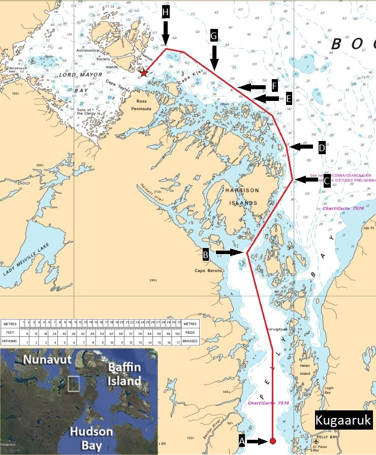
| Waypoint | Date and time (Mountain Daylight Time - UTC-6) | Description of event |
|---|---|---|
| A | 23 August 2018 2045 |
Departure from the anchorage in Pelly Bay off Kugaaruk |
| B | 24 August 2018 0000 |
Change of course for the narrows at the entrance of Pelly Bay |
| C | 24 August 2018 0252 |
Change of course to 352°G to navigate around the Harrison Islands |
| D | 24 August 2018 0440 |
Change of course to 336°G to navigate around the Harrison Islands |
| E | 24 August 2018 0738 |
Deviation Report (DR) sent to Northern Canada Vessel Traffic Services (NORDREG) |
| F | 24 August 2018 0801 |
NORDREG acknowledges receipt of DR; TC accepts the new passage plan |
| G | 24 August 2018 0847 |
Musters and safety briefings initiated |
| H | 24 August 2018 1027 |
Change of course to 221°G to enter the narrows between the Ross Peninsula and the Astronomical Society Islands |
| Star | 24 August 2018 1113 |
Vessel runs aground on uncharted rocky shoal |
Appendix B – Satellite-derived imagery showing potential shoals in the vicinity of the Astronomical Society Islands
In response to the grounding of the Akademik Ioffe, and to support anticipated vessel movements in the vicinity of the grounding location during the search and rescue response, the Canadian Hydrographic Service (CHS) analyzed several satellite imagery sources to identify the position of potential shoals. The CHS could not evaluate the depth of these shoals. To provide this preliminary data, the CHS used PlanetScope imagery from 22 August 2018 and Sentinel-2 imagery from 22 September 2017 and 18 August 2018.
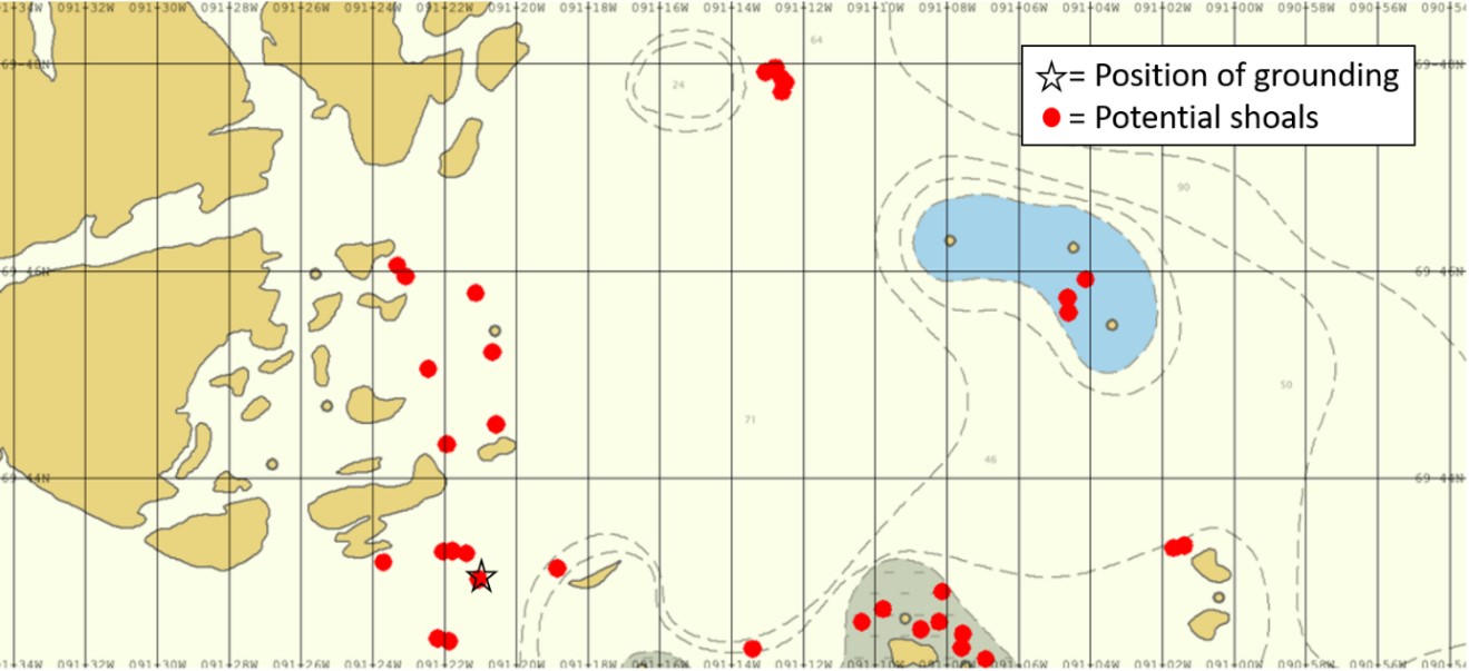
Appendix C – Previous occurrences
Occurrences in Canadian Arctic waters
M96H0016 (Hanseatic) – On 29 August 1996, the Hanseatic ran aground in Simpson Strait while on passage from Gjoa Haven, Nunavut, to Resolute Bay, Nunavut. The weather was fine and clear and the vessel was being navigated visually, by reference to shore ranges, and by radar. The passage plan was disrupted when it was assumed that a buoy, which had been left in the strait from the previous navigation season, was marking a shoal. The buoy had been moved out of position by ice.
The Board determined that the Hanseatic grounded because the bridge team did not strictly adhere to the plan that had been prepared for navigating the vessel through the strait. Relying on a navigation buoy left in the strait from the previous navigation season contributed to the grounding.
M08H0011 (Akademik Ioffe) – On 04 September 2008, the Akademik Ioffe nearly touched bottom when it sailed close to an uncharted shoal in the Coronation Gulf, Nunavut. The vessel crew was able to take evasive action as the vessel’s echo sounders read a water depth that abruptly diminished to 16 m. At the time, the vessel was sailing along a line of spot soundings that showed a water depth of 29 m, according to Canadian Hydrographic Service (CHS) navigation chart 7777.Footnote 192
M09L0147 (Zelada Desgagnés) – On 31 August 2009, the Canada-flagged general cargo vessel Zelada Desgagnés made contact with the bottom while exiting the Povungnituk River off Puvirnituq, Quebec. Some ballast water tanks were breached and minor pollution was reported.
M09H0007 (Amundsen) – On 18 October 2009, the Canadian Coast Guard (CCG) vessel Amundsen grounded in Prince of Wales Strait, Northwest Territories. The vessel was successfully refloated at high tide.
M10H0006 (Clipper Adventurer) – On 27 August 2010 at approximately 1832, the Bahamas-flagged passenger vessel Clipper Adventurer ran aground in the Coronation Gulf on the same uncharted shoal that had been previously reported by the Akademik Ioffe in September 2008. No injuries were reported. Two days following the occurrence, the vessel’s 128 passengers were transferred to the CCG vessel Amundsen and taken to Kugluktuk, Nunavut.
The Clipper Adventurer was refloated on 14 September 2010; the hull had sustained extensive damage and 13 of the vessel’s double bottom tanks and compartments, including 4 fuel oil tanks, were breached. The TSB’s investigation determined that the CHS’s practice of not issuing and applying chart corrections using Position Approximate (PA) and Position Doubtful (PD) symbols increases the risk that mariners will not be aware of known hazards when they do not obtain the applicable Notices to Shipping (NOTSHIPs).
The investigation also established that when receiving sailing plan reports and providing routing advice to vessels, Northern Canada Vessel Traffic Services (NORDREG) does not proactively advise vessels about active NOTSHIPs for the areas they will transit, which may place vessels at increased risk if they have not obtained the information by other means. The investigation also concluded that unless a vessel is assessed for seaworthiness prior to a refloating attempt, the safety of the vessel, its passengers, and crew may be at risk.
Finally, the investigation established that at the time of the occurrence, the Clipper Adventurer was fitted with a forward-looking sonar system; however, it was unserviceable. With this system unserviceable, the vessel bridge team relied on the SOLAS-required echo sounder to monitor the accuracy of the charted soundings. However, because the echo sounder provided the depth beneath the vessel and not the depth ahead, the vessel struck the shoal at full sea speed.
M10H0007 (Nanny) – On 01 September 2010, the Canada-flagged oil products/chemical tanker Nanny ran aground in Simpson Straight, Nunavut. No pollution or injuries were reported.
M12H0008 (Atlantic Teak) – On 05 August 2012, the Canada-flagged tug Atlantic Teak was towing the cargo barge Atlantic Sea Lion when both ran aground in Chesterfield Inlet, Nunavut. The tug and barge were later refloated and proceeded to Baker Lake, Nunavut. No pollution or injuries were reported.
M12H0011 (Dorsch) – On 24 October 2012, the Canada-flagged oil products/chemical tanker Dorsch ran aground in Baker Lake, Nunavut, and was later refloated after its ballast water was pumped out. No damage, pollution, or injuries were reported.
M12H0012 (Nanny) – On 25 October 2012, the Canada-flagged oil products/chemical tanker Nanny ran aground on a shoal in Chesterfield Narrows, Nunavut. On 27 October, the vessel came off the shoal during strong northwesterly winds. No pollution or injuries were reported. The forward section of the vessel’s hull was indented and breached, and the bow thruster, stern thruster, and both bilge keels sustained damage.
M13H0002 (Island Tugger) – On 27 July 2013, the Canada-flagged tug Island Tugger ran aground off Tuktoyaktuk Island in Kugmallit Bay, Northwest Territories. No damage, pollution, or injuries were reported.
M14C0219 (Nanny) – On 14 October 2014, the Canada-flagged oil products/chemical tanker Nanny made bottom contact west of Deer Island in the Chesterfield Inlet, Nunavut. No pollution or injuries were reported. Structural damage occurred and the hull’s shell plating was breached in 2 places. The investigation identified several shortcomings with the way the vessel’s on-board safety management system was implemented, and determined that a lack of continued proficiency in bridge resource management principles among bridge watch officers may impair bridge team situational awareness and effectiveness.
M18C0275 (Fathom Wave) – On 27 September 2018, the Canada-flagged tug Fathom Wave struck the bottom and began taking on water off Cambridge Bay, Nunavut. The crew made temporary repairs and the vessel resumed its operations.
M19C0276 (Hanse Explorer) – On 23 August 2019, the Antigua and Barbuda-flagged charter yacht Hanse Explorer ran aground in Admiralty Inlet (Baffin Island) off the Peter Richards Islands, Nunavut, with 26 people on board. No pollution or injuries were reported. The vessel sustained minor damage to the hull’s antifouling coating. At the time of the occurrence, the vessel was using the local CHS-issued electronic navigational chart (ENC); during its approach to Levasseur Inlet at a speed of 9 knots, the under-keel water depth abruptly diminished from 44 m to 0 m and the vessel ran aground.
Occurrences in Canadian non-Arctic waters
M12L0045 (Coriolis II) – On 16 May 2012, the Canada-flagged research vessel Coriolis II ran aground off Pointe-des-Monts, Quebec, while conducting geophysical surveying. The vessel sustained damage to its hull, rudder, and port propeller.Footnote 193 Although the Coriolis II did not run aground in the same geographical area as the Akademik Ioffe, a similar misuse of electronic-format navigation charts was identified in both occurrences. The investigation determined that the crew did not use the CHS-issued navigation chart in its paper format because of its fixed scale of 1:200 000; instead crew used the corresponding ENC in conjunction with the vessel’s electronic chart system (ECS) to manually increase the scale and better distinguish the bathymetric curves of the chart. This technique gave crew a false sense of safety in relation to the vessel draught against the water depth shown on the chart.
M15A0056 (Ann Harvey) – On 01 April 2015, the CCG vessel Ann Harvey was conducting buoy tending operations when it struck an uncharted shoal off Burgeo, Newfoundland and Labrador. The vessel’s hull was breached and the propulsion motor room flooded. The vessel was towed to a dry dock for repairs.Footnote 194 Although the Ann Harvey did not touch bottom in the same geographical area as the Akademik Ioffe, a similar unreliability with CHS-issued navigation charts was identified in both occurrences. The investigation determined that the hydrographic data used by the CHS for charting the area of the occurrence were based on a lead line survey carried out in 1872, and that, like most of Canada’s Arctic waters, several other areas around Newfoundland and Labrador were not surveyed to modern standards. The CHS-issued digital navigational chart format (raster) did not show the shoal, despite the fact that a 3.7 m deep shoal had been reported in 1993 in the local Sailing Directions, after the Ann Harvey made bottom contact with it.
M16C0005 (MSC Monica) – On 22 January 2016, the Panama-flagged container vessel MSC Monica ran aground off Deschaillons-sur-Saint-Laurent, Quebec. The vessel was refloated the following day, with the assistance of 3 tugs. The vessel sustained minor damage to its hull and major damage to its 4 propeller blades. Although the MSC Monica did not run aground in the same geographical area as the Akademik Ioffe, similar contributing human factors and issues with bridge resource management were identified in both occurrences. The investigation pointed out the issue of the power distance principle as a factor that played a role in the occurrence, and that if bridge team members do not share a complete understanding of an emerging problem and continuously exchange information to resolve it, there is a risk that the bridge team’s response will be premature, uncoordinated, and ineffective.
Occurrences in foreign waters
The Akademik Ioffe was also involved in an allision in polar waters outside Canada, which emphasizes the increased probability of risks to safety for passenger-carrying vessels conducting expedition cruises in remote areas.
On 26 February 2013, the Akademik Ioffe struck an iceberg in the Palmer Archipelago in Antarctica. No pollution or injuries were reported. The vessel proceeded to Ushuaia, Argentina, and arrived on 03 March for inspection, which revealed that the vessel’s hull had sustained damage. The vessel sailed to Bremerhaven, Germany, where it was dry-docked for repairs on 08 April.Footnote 195
Glossary
- AIRSS
- Arctic Ice Regime Shipping System
- APPC
- Arctic Pollution Prevention Certificate
- AR
- Authorized Representative
- ASPPR
- Arctic Shipping Pollution Prevention Regulations
- BIMCO
- Baltic and International Maritime Council
- BRM
- bridge resource management
- CAF
- Canadian Armed Forces
- CAMSAR
- Canadian Aeronautical and Maritime Search and Rescue
- CCG
- Canadian Coast Guard
- CHS
- Canadian Hydrographic Service
- CJOC SAR
- Canadian Joint Operations Command Search and Rescue
- DFO
- Department of Fisheries and Oceans
- DOC
- document of compliance
- DR
- Deviation Report
- DSC
- digital selective calling
- DSS
- decision support system
- ECDIS
- electronic chart display and information system
- ENC
- electronic navigational chart
- ETA
- estimated time of arrival
- FAA
- U.S. Federal Aviation Administration
- GMDSS
- Global Maritime Distress and Safety System
- IAMSAR
- International Aeronautical and Maritime Search and Rescue
- ICCL
- International Council of Cruise Lines
- ICS
- International Chamber of Shipping
- IEC
- International Electrotechnical Commission
- IFO
- intermediate fuel oil
- IHO
- International Hydrographic Organization
- IMO
- International Maritime Organization
- IO RAS
- P.P. Shirshov Institute of Oceanology of Russian Academy of Sciences
- IRB
- inshore rescue boat
- ISM Code
- International Management Code for the Safe Operation of Ships and for Pollution Prevention
- IUMI
- International Union of Marine Insurance
- JRCC
- Joint Rescue Coordination Centre
- LISC
- low impact shipping corridor
- MAJAID
- major aeronautical disaster
- MAJMAR
- major maritime disaster
- MARPOL
- International Convention for the Prevention of Pollution from Ships
- MCTS
- Marine Communications and Traffic Services
- MGO
- marine gas oil
- MoU
- memorandum of understanding
- NAVTEX
- Navigational Telex
- NAVWARN
- Navigational Warning
- NM
- nautical mile
- NORDREG
- Northern Canada Vessel Traffic Services
- NOTMAR
- Notices to Mariners
- NOTSHIP
- Notices to Shipping
- OOW
- officer of the watch
- PA
- public address
- PDI
- power distance index
- PFD
- personal floatation device
- PSC
- Port State Control
- RO
- recognized organization
- SAR
- search and rescue
- SMC
- safety management certificate
- SMS
- safety management system
- SOLAS
- International Convention for the Safety of Life at Sea, 1974
- SOPs
- standard operating procedures
- SP
- Sailing Plan
- SRR
- search and rescue region
- SRU
- search and rescue unit
- STCW
- International Convention on Standards of Training, Certification, and Watchkeeping for Seafarers
- TC
- Transport Canada
- TSB
- Transportation Safety Board of Canada
- VDR
- voyage data recorder