Bottom contact
"Irving Nordic"
St Lawrence River
Near Grondines, Quebec
The Transportation Safety Board of Canada (TSB) investigated this occurrence for the purpose of advancing transportation safety. It is not the function of the Board to assign fault or determine civil or criminal liability. This report is not created for use in the context of legal, disciplinary or other proceedings. See Ownership and use of content. Masculine pronouns and position titles may be used to signify all genders to comply with the Canadian Transportation Accident Investigation and Safety Board Act (S.C. 1989, c. 3).
Summary
On 08 May 1991, at about 0828, while downbound in the St. Lawrence River with a cargo of oil, the Canadian tanker "IRVING NORDIC" struck bottom to the north of the ship channel, downstream of the Grondines wharf. The vessel ran out of the navigation channel in daylight and in conditions of good visibility. The "IRVING NORDIC" suffered considerable bottom damage, but there were no injuries. Minor pollution was observed as the vessel arrived at Québec (Quebec), but it was contained.
The Board determined that the "IRVING NORDIC" struck bottom because the vessel left the navigation channel as a result of a premature alteration of course.
1.0 Factual information
1.1 Particulars of the vessel
| Name of vessel | "IRVING NORDIC" |
|---|---|
| Official number | 369846 |
| Port of registry | Saint John, New Brunswick |
| Flag | Canada |
| Type | Oil tanker |
| Gross TonsFootnote 1 | 7,745 |
| Length | 132.26 m |
| Breadth | 20.5 m |
| Draught | FFootnote 2: 7.40 m A: 7.36 m |
| Built | 1980, Saint John, New Brunswick |
| Propulsion | Marine diesel engine of 7,504 BHP (5,520 kW) driving a single controllable-pitch propeller |
| Owners | Kent Line Ltd. Saint John, New Brunswick |
1.1.1 Description of the Vessel
The "IRVING NORDIC" is a tanker of conventional single-skin construction. The navigation bridge, accommodation and machinery space are aft.
1.2 History of the voyage
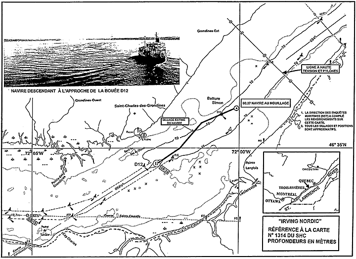
On the morning of 08 May 1991, the "IRVING NORDIC" was downbound in the St. Lawrence River en route from Sarnia, Ontario, to Norfolk, Virginia, with a cargo of 10,970 tonnes of Bunker 'C'. There had been a change of pilots at Trois-Rivières, Quebec, at 0630Footnote 3, and the pilot, who had the conduct of the vessel, was navigating by visual references. The vessel's average speed over the ground was 15.7 knots (kn). There was no other traffic in the immediate vicinity.
At 0824, the vessel was at the call-in point (CIP) off the Grondines wharf, with the Calvaire ranges astern, and was steering 055° Gyro (G). The pilot notified both Montreal and Québec Vessel Traffic Services (VTS) that he was passing the Grondines CIP and provided the Québec VTS with an estimated time of arrival (ETA) for the next CIP. At this time, the officer of the watch (OOW) took the information from the radar display and proceeded to the chart table to plot the position. After completing the VTS reports at about 0826, the pilot ordered an alteration of course to 042° (G). The helmsman repeated the order and brought the "IRVING NORDIC" onto the new course.
The helmsman was able to hold the new heading for only a short period before finding that full port helm was required to keep the vessel on course. As the "IRVING NORDIC" then began to "shake/vibrate", the OOW returned to the forward end of the wheel-house without completing the plotting of the vessel's position. The pilot was surprised that the rudder angle indicator showed the helm hard over to port and, suddenly realizing that the vessel was to port of the intended track, ordered the helmsman to steer 052° (G). By this time, the ship's head was already to starboard of 052°, so the helmsman kept the helm hard over to port.
Seeing that the rudder angle indicator still showed the helm hard over to port, the pilot surmised that the steering had failed and directed the OOW to stop the main engine and drop the anchors to stop the vessel as quickly as possible. As the OOW hurried to carry out these orders, the master, who had been below and had been alerted by the vessel's unusual movement, arrived on the bridge. In answer to the master's enquiry as to whether there had been an engine breakdown, the pilot replied that he thought the steering gear had malfunctioned. The master put the main engine control to full astern. Buoy D4, which had been some 100 m fine on the starboard bow when the master arrived on the bridge, was lost to sight with the vessel apparently passing over it. The "IRVING NORDIC" continued to move ahead, though she was reducing speed, until the OOW dropped both anchors. When brought up, the "IRVING NORDIC" was about 600 m downstream of buoy D4 and back in the navigation channel. It is considered that the vessel had struck bottom in a position with buoy D4 bearing approximately 070° at a distance of three cables at about 0828.
At 0838, the "IRVING NORDIC" reported to Québec VTS that she had anchored in mid-channel because of a steering gear failure. At 0928, it was confirmed to VTS that the vessel had struck bottom and that the bow thruster compartment had flooded, but that there was no risk of pollution.
At 0959, the "IRVING NORDIC" departed the anchorage for Québec under her own power. At 1344, she was secured at section 53 in the port of Québec.
1.3 Injuries to persons
There were no injuries as a result of this occurrence.
1.4 Damage
1.4.1 Damage to the vessel
The damage to the shell plating of the "IRVING NORDIC" was mainly on the port side of the vessel, where the setting-up and distortion of the bottom plating extended aft as far as amidships at the turn of the bilge. The port bilge keel required part renewal, and the forepeak tank, the bow thruster compartment and the cofferdam forward of the cargo tanks were holed and flooded. The No. 1 port cargo tank was also holed.
1.4.2 Environmental damage
A Canadian Coast Guard (CCG) helicopter escorted the "IRVING NORDIC" to the port of Québec and observed no oil spill.
Oil was seen escaping from the No. 1 tank as the vessel was approaching section 53, but a boom was quickly deployed and the spill was contained. The spill was estimated to have been about one barrel. Traces of oil were reported at the Lévis marina, but they could not be confirmed as having come from the "IRVING NORDIC".
1.4.3 Other Damage
On 30 May, the CCG examined buoy D4 and discovered minor denting and chipped paint above the waterline, but there is no evidence to show that the "IRVING NORDIC" caused this damage.
1.5 Certification
1.5.1 Vessel Certification
The "IRVING NORDIC" was manned, certificated and equipped in accordance with existing regulations.
1.5.2 Personnel Certification
The crew members of the "IRVING NORDIC" who were directly involved in this occurrence held the appropriate certification, and the pilot was appropriately licensed.
1.6 Personnel History
1.6.1 Master
The master had served as a watchkeeping officer since 1981 and as a master for one year. During his career, he had traded regularly in the St. Lawrence River. He had joined the "IRVING NORDIC" on 03 May 1991, at Sarnia.
1.6.2 Officer of the Watch (OOW)
The OOW on the "IRVING NORDIC" had been going to sea for eight years, including 10 months as a watchkeeping officer, during which time he had made 16 voyages in the St. Lawrence River. He had been on the "IRVING NORDIC" for nine weeks.
1.6.3 Pilot
The pilot had 11 years' pilotage experience between Québec and Trois-Rivières (Quebec).
1.6.4 Helmsman
The helmsman had 30 years' sea service, including 14 as helmsman. He had joined the "IRVING NORDIC" in March 1991.
1.7 Weather and Tidal Information
The "IRVING NORDIC" recorded partly cloudy skies, very good visibility and a wind from the west at 10 to 15 kn.
High tide at Grondines was forecast for 0435 and was predicted to reach a height of 2.7 m above chart datum. At 0830, the tide gauge at the Portneuf wharf, about eight miles downstream of buoy D4, indicated a water level of 2.3 m (7.4 feet) above chart datum. Thus, the foreshore in the Grondines area would have been completely flooded up to the shoreline. The ebb current was estimated to have been at 3 to 3.5 kn at the time of the occurrence.
1.8 Navigation Equipment
1.8.1 Vessel
The vessel was fitted with modern navigation instruments that were reportedly in good working order. The starboard radar set and the echo-sounder were both in operation.
Canadian Hydrographic Service (CHS) chart No. 1314 was in use, but the chart had not been corrected and updated in accordance with Notices to Mariners. The location shown for the Grondines CIP was incorrect, and the position of the overhead power cables and pylons about one mile downstream of the occurrence site was not indicated.
1.8.2 Aids to Navigation
All navigation aids in the area were reported to be in position and operating normally at the time of the occurrence.
When the vessel struck bottom, the pilot was intending to turn into a section of the channel in which there are no ranges. This section of the channel begins about 1.3 miles downstream of the Grondines wharf and extends 1.1 miles from buoy D4 to buoy Q84. The latest edition of the Sailing Directions published by the CHS advises that "Cap Lauzon and the right fall of Mont Triquet, prominent mountain north of Québec, in line bearing 042°, leads through that portion of the ship channel...", but warns that "this landmark is visible in clear weather only." In this case, the weather was clear.
The downbound channel is marked to port by buoys D4 and Q84. On the starboard hand, buoy Grondines A marks the anchorage at the side of the channel, and Pointe Langlois light, which displays fluorescent orange daymarks, marks the shore.
More prominent and conspicuous in terms of delineating the navigation channel are the pylons for the power transmission line that straddles the channel near buoy Q84, about one mile downstream of the occurrence site. The two towers are located on artificial islands situated 125 m outside of the 800 m-wide navigation channel and are marked by stroboscopic lights. The transmission line was erected in 1990 but was intended to be only temporary, pending the installation of a submarine cable.
1.9 Radio Communications
All radio communications were handled by the pilot.
1.10 Emergency Equipment
When the "IRVING NORDIC" was moored at Québec, a boom carried on board was deployed around the vessel to contain the small quantity of oil that had leaked.
1.11 Conduct of the "IRVING NORDIC"
As the master was below, three persons were present on the bridge: the pilot, the OOW and the helmsman. The pilot had the conduct of the vessel, the OOW was
monitoring the vessel's progress, and the helmsman was steering the vessel manually.
The OOW regularly plotted the vessel's radar position on the chart and recorded the times. He was about to plot the 0824 position when the vessel struck bottom.
The pilot stated that when the course alteration to 042° (G) was ordered, the vessel was near the centre line of the channel, and Cap Lauzon and a mountain, identified by him as Mont Bélair, were in transit and slightly to port in the distance. Pointe Langlois lighthouse was forward of the starboard beam at this time. Once the course alteration was completed, the pilot did not check the relative position of the buoys and other landmarks which would have indicated that he had altered course prematurely.
Also, after altering onto 042°, the helmsman did not tell the pilot or the OOW that he was having difficulty steering. When the pilot saw that the vessel was to port of the intended track and ordered the alteration to 052° (G), the helmsman did not advise the pilot or the OOW that the vessel was already to starboard of that heading and that the helm was hard-a-port. The pilot made no enquiries of the helmsman and concluded that the steering gear had malfunctioned. The pilot maintained throughout the investigation that a steering gear malfunction had caused the vessel to run out of the channel.
1.12 Piloting Procedures
Testimony from St. Lawrence River pilots indicates that pilots normally use familiar shore-based landmarks when navigating visually. They seldom use buoys or temporary markers since such aids can frequently be missing or out of position in winter. The most important mark used by pilots in the area of this occurrence is the alignment of Cap Lauzon with the right fall of Mont Triquet.
1.13 Steering Gear
The steering gear on the "IRVING NORDIC" is electric-hydraulic, and it has two power units and two independent control units. At the time of the occurrence, both power units were in use, a normal procedure for confined waters, and the port control unit was in operation. When a steering malfunction was suspected, no attempt was made to switch to the starboard control unit. The engineer of the watch, who was in the steering flat after being informed of the supposed steering gear malfunction, saw the rudder move from hard-a-port to amidships, apparently operating normally. When the vessel was at anchor, immediately after the occurrence, the steering gear was tested hard-over to both sides and found fully operational. The following day, a technician from a shore maintenance company found no problem with the steering gear. Alarms on the bridge and in the engine-room, both visual and audible, functioned normally. No alarm was seen or heard, either on the bridge or in the engine-room, at the time of the suspected steering failure.
2.0 Analysis
2.1 The Alteration of Course
The pilot ordered the alteration of course because he thought that the vessel had reached the alter-course position off buoy D4, about 1.3 miles downstream of the Grondines wharf CIP. At a speed of almost 16 kn, the vessel would have taken about five minutes to cover that distance. However, the order for the alteration to port must have been given shortly after the vessel passed the Grondines CIP because, when the master reached the bridge, he saw buoy D4 some 100 m ahead and fine on the starboard bow. Furthermore, the OOW obtained radar information to plot the vessel's position on passing the Grondines CIP, proceeded to the chart table but did not have time to plot the vessel's position before the "vibrations" started. It would therefore appear that the alteration of course order was given prematurely. Given the pilot's navigational experience in this area, it seems likely that he was distracted by such requirements as ETA computations or position reporting to VTS. However, the precise reasons for this could not be determined.
2.2 Recognition of the Premature Alteration
Proper navigation techniques and utilization of all available landmarks after the alteration onto 042° (G) would have made it evident that the "IRVING NORDIC" was on the wrong heading. Buoy D4, for example, should have been on the port bow but, instead, it was fine on the starboard bow. The transmission line pylon, which also should have been to port, was ahead. The pilot evidently did not check these markers after the alteration was effected.
As the master's representative, the OOW is also responsible for the vessel's safety and for monitoring the pilot's actions. The OOW had little opportunity to influence the situation. Although he was monitoring the vessel's progress, he was doing so by the use of radar fixes which do not provide the precision or rapid reaction time required for navigation in confined channels. He had limited experience on the St. Lawrence River and frequently had to refer to the chart to identify landmarks. The transmission line, which offers a good reference mark in that section of the channel, was not marked on the chart. Once the alteration to port was initiated, there would have been less than two minutes to detect the error before the "IRVING NORDIC" contacted the bottom. Once the vibrations had started, indicating shallow water, the OOW had no time to consider remedial action and had little choice but to follow the pilot's instructions to let go the anchors.
2.3 Steering Gear
The post-occurrence check of the steering gear failed to uncover any irregularities. The pilot's perception of a steering problem appears to have stemmed from a breakdown in proper seamanship practices.
When the pilot gave the order for the alteration of course to 042° (G), the helmsman correctly repeated the order before putting it into effect. However, he did not advise the pilot that he was having difficulty in maintaining the new course, nor did he advise the pilot of the vessel's heading when the second alteration was ordered.
For his part, the pilot did not question the helmsman about the position of the wheel and, therefore, did not fully understand the nature of the problem. His conclusion that the steering gear had malfunctioned was probably based on incorrect assumptions.
3.0 Findings
3.1 Findings
- The "IRVING NORDIC" left the navigation channel between the Grondines wharf call-in point (CIP) and buoy D4 and contacted the bottom.
- The alteration out of the channel was made in response to an order from the pilot, who believed the vessel to be farther downstream than she was.
- The pilot did not check the relative position of buoys and other landmarks after the alteration of course was completed.
- The helmsman did not advise the pilot that he was experiencing difficulty in holding the vessel on course.
- The pilot did not question the helmsman about the position of the wheel relative to the rudder angle indicator.
- By the time the pilot realized that the vessel was too far to port, it was too late to prevent the vessel from leaving the channel.
- The pilot's order for corrective helm action was ineffective because he did not realize that the ship's head was already starboard of the course he had directed; thus, the helm remained at hard-a-port.
- The pilot assumed that the steering gear had malfunctioned.
- The steering gear functioned normally before and after the occurrence, and tests did not reveal any evidence of a malfunction.
- The officer of the watch's (OOW) method of monitoring the vessel's progress was not sufficiently precise to prevent the occurrence.
3.2 Causes
The "IRVING NORDIC" struck bottom because the vessel left the navigation channel as a result of a premature alteration of course.
4.0 Safety Action
4.1 Action Taken
4.1.1 Global Positioning System (GPS)
Following this occurrence, the owners installed GPS receivers on all the vessels of their fleet.
4.1.2 Charts and Publications
In 1991, following the accident, the TSB apprised the Canadian Coast Guard (CCG) of the importance of carrying the latest editions of nautical charts on board.
4.1.3 Bridge Resource Management (BRM)
Once again, a general lack of interaction and coordination between the bridge personnel and the pilot contributed to this marine accident. There was no effective exchange of navigational and operational information (including passage planning) between the officers of the ship and the pilot. Poor communications on the bridge, interrupted procedures, lack of situational awareness, lack of teamwork between pilots and ships' officers, etc. have been contributory factors in several similar occurrences in recent years. In its reports on the groundings of the Norwegian chemical tanker "LAKE ANINA" in Montreal, Quebec (TSB Report #M90L3016), of the Canadian product tanker "EASTERN SHELL" in Georgian Bay, Ontario (TSB Report #M91C2008), of the Yugoslavian bulk carrier "MALINSKA" in Lake Ontario (TSB Report #M91C2009), and of the Swedish container vessel "CONCERT EXPRESS" in Halifax, Nova Scotia (TSB Report #M92M4023), the Board expressed concerns about serious shortcomings in the effectiveness of current bridge resource management (BRM) practices on vessels in Canadian waters. Due to the frequency of such occurrences, the Board is currently studying the operational relationships between ships' masters, officers of the watch (OOW) and marine pilots. Based on the findings of this study, the Board will make appropriate safety recommendations to improve the effectiveness of BRM practices on vessels with pilots in Canadian waters.
4.2 Action Required
4.2.1 Passage Planning
The pilot prematurely made the alteration of course putting the ship's head to the north of the north power-line pylon. Such a conspicuous mark should have warned the pilot and the OOW of the impending danger of the vessel being off course. Further, buoy D4 was on the starboard bow, another indication that the vessel was off course. However, this course deviation went unrecognized by the pilot and the OOW. Such errors could have been detected if adequate passage planning had been put in place and if the progress of the vessel had been monitored effectively. In confined compulsory pilotage waters, a pilot's passage plan containing all key navigational elements such as course alteration points, wheel-over positions, and points where the accuracy of position fixing is critical, etc. could reduce the risk of such errors.
Approximately two months after this occurrence, the Canadian bulk carrier "HALIFAX" grounded in the same area, also due to a premature alteration of course (TSB Occurrence #M91L3015).
The Board believes that close and continuous monitoring of a vessel's progress along the pre-planned track is essential for the safe conduct of the vessel. Knowledge of the pilot's passage plan would provide a focus for the OOW to effectively monitor the intentions of the pilot, the track and the progress of the vessel. Currently, it is not common practice for pilots to provide passage plans to ship's personnel or for the pilotage authorities to provide such plans to their pilots. Therefore, the Board recommends that:
The Department of Transport require that the pilotage authorities publish official passage plans for compulsory pilotage waters and make them available to masters to facilitate monitoring of the pilot's actions by the vessel's bridge team.
Transportation Safety Recommendation M94-34
4.3 Safety Concerns
4.3.1 Navigational Aids--Range Lights
The pilot's premature alteration of course from 058° to 042° (G) was made at a point where there are no range marks or lights to guide the vessel on the approximate 044°(T) track. Apart from a distant mountain (Mont Triquet) lining up with Cap Lauzon (only visible in good conditions of visibility), there are no day range marks or night range lights leading through that portion of the channel for a distance of 1.3 miles, and there is no recommended course on the chart.
In the grounding of the "HALIFAX" at the same location during a calm and clear night, the pilot mistook the rear St. Emmelie range light for the Pointe Langlois light. Also, on 18 June 1979, the bulk carrier "GOLDEN HIND" touched bottom in similar circumstances near buoy D4.
The Board is concerned by the lack of range marks/lights to assist pilots in making visual confirmation for the passage in that section of the St. Lawrence River. The publication and dissemination of official passage plans as recommended above would alleviate this problem, if sufficient detail is provided.
4.3.2 Navigational Practices
Over the last decade (1982-1991), evidence suggests that over 60 per cent of groundings and bottom contacts in Canadian waters have been attributable, at least in part, to procedural deficiencies and inadequate watchkeeping practices.
In the case of the "IRVING NORDIC", the pilot did not check the relative position of the buoys and other landmarks immediately after the alteration of course was completed. The same was true in the grounding of the "HALIFAX" in July 1991. Contrary to well established navigational practices, some pilots do not routinely check all available landmarks or confirm the vessel's position with the radar before and after course alterations while approaching the Saint-Charles-des-Grondines call-in point.
The Board is concerned that in spite of the presence of competent pilots and officers on the bridge, there is a significant frequency of similar occurrences in which well established navigational procedures are not followed. Past occurrences have not enabled the TSB to identify the underlying factors of this failure to follow established navigational practices. Therefore, the Board will emphasize this particular area in its analysis of future occurrences with a view to making specific safety recommendations.
This report concludes the Transportation Safety Board's investigation into this occurrence. Consequently, the Board, consisting of Chairperson, John W. Stants, and members Gerald E. Bennett, Zita Brunet, the Hon. Wilfred R. DuPont and Hugh MacNeil, authorized the release of this report on .
Appendices
Appendix A - Chart - Area of Occurrence
Appendix B - Photographs
Appendix C - Glossary
- A
- aft
- BHP
- brake horsepower
- BRM
- Bridge Resource Management
- cable
- Fibre or wire rope; anchor chain; one tenth of a nautical mile (185 m).
- CCG
- Canadian Coast Guard
- chart datum
- Plane below which the tide seldom falls and to which depth information on a chart is reduced.
- CHS
- Canadian Hydrographic Service
- CIP
- call-in point
- EDT
- eastern daylight time
- ETA
- estimated time of arrival
- F
- forward
- G
- gyro (compass course, heading or bearing)
- GPS
- Global Positioning System
- IMO
- International Maritime Organization
- kn
- knot(s): one nautical mile per hour
- kW
- kilowatt(s)
- m
- metre(s)
- OOW
- officer of the watch
- ranges
- Lights or markers (ashore) placed in line to indicate the course to steer.
- SI
- International System (of units)
- single-skin
- Constructed such that the outer boundary of the (oil) cargo compartments is the vessel's shell plating; without side-wing tanks and double-bottom tanks.
- steering flat
- Compartment in the afterpart of a vessel, above the rudder, in which the steering engine, quadrant, etc. are located.
- TSB
- Transportation Safety Board of Canada
- UTC
- Coordinated Universal Time
- VTS
- Vessel Traffic Services
- °
- degree(s)