Collision with vehicle and terrain
Privately registered
Cessna 182P, C-GIDY
Langley Regional Airport, British Columbia
The Transportation Safety Board of Canada (TSB) investigated this occurrence for the purpose of advancing transportation safety. It is not the function of the Board to assign fault or determine civil or criminal liability. This report is not created for use in the context of legal, disciplinary or other proceedings. See Ownership and use of content. Masculine pronouns and position titles may be used to signify all genders to comply with the Canadian Transportation Accident Investigation and Safety Board Act (S.C. 1989, c. 3).
History of the flight
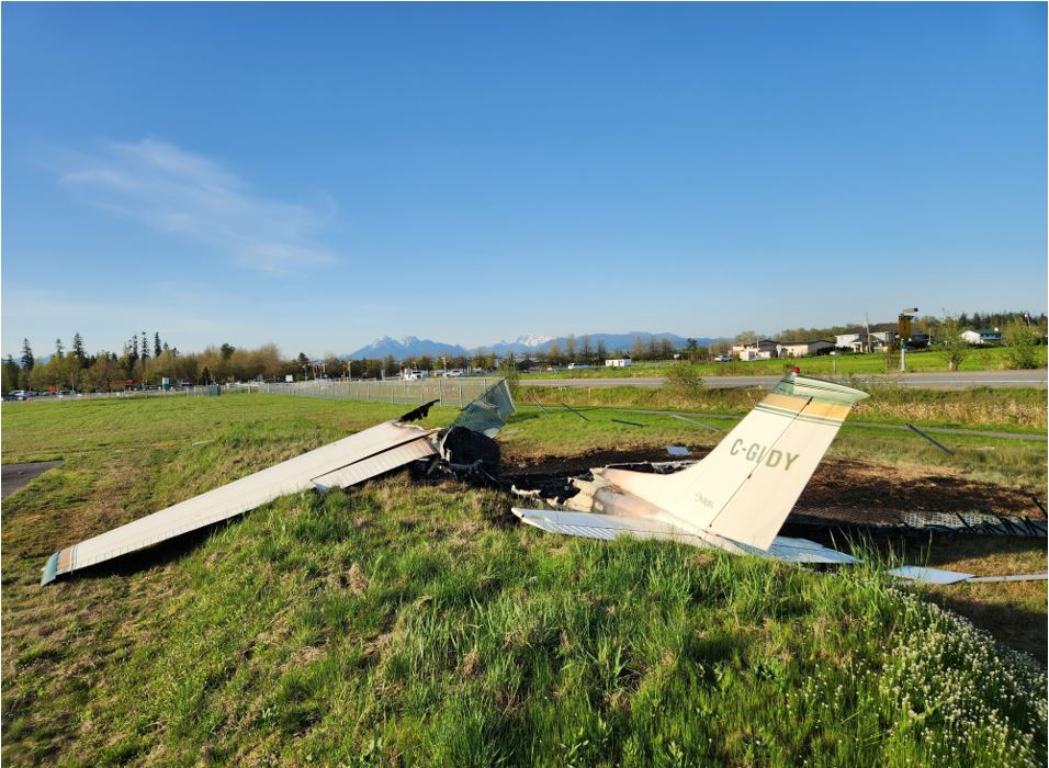
On 02 May 2023, the privately registered Cessna 182P (registration C-GIDY, serial number 18261845) was conducting a visual flight rules sightseeing flight from Langley Regional Airport (CYNJ), British Columbia, with the pilot and 1 passenger on board. On return to CYNJ, the pilot conducted a straight-in approach to Runway 25. At approximately 1502,Footnote 1 the aircraft was observed to be low on the approach. Shortly after, the aircraft struck a pickup truck that was driving on 216 Street, a public road, approximately 450 feet east of the runway's displaced threshold. It then struck the airport perimeter fence approximately 60 feet west of the initial impact with the pickup truck and slid a further 30 feet before it came to rest against a berm (Figure 1). A post-impact fire started shortly after. The passenger was able to exit the aircraft unassisted, and a bystander helped the pilot out of the aircraft. The pilot received serious injuries and the passenger received minor injuries; both were airlifted to hospital. The driver of the pickup truck received minor injuries and was taken to hospital via ground ambulance. Firefighters extinguished the aircraft fire and the associated grass fire; the aircraft was destroyed.
Wreckage and impact information
Based on video and photographic evidence of the accident, as well as examination of the site, the aircraft was aligned with the runway centreline before it struck the pickup truck. After the impact with the truck and the airport perimeter fence, the aircraft pivoted 90° to the right and impacted the berm. It was destroyed in the post-impact fire (Figure 2). All major components of the aircraft were accounted for at the accident site.
There was significant damage to the pickup truck (Figure 3), the airport fence, and the surrounding grassy area, adjacent to the runway.
Pilot information
The pilot held a private pilot licence, which was the appropriate licence for the flight in accordance with regulations.
According to information gathered during the investigation, there was no indication that the pilot’s performance was affected by medical or physiological factors.
Weather information
CYNJ issues an hourly limited weather information system (LWIS) report. The report issued at 1500, shortly before the occurrence, indicated the following:
- Winds from 270° true (T) at 8 knots, variable from 220°T to 290°T
- Temperature 23 °C, dew point 12 °C
- Altimeter setting 29.67 inches of mercury (inHg)
The nearest airport issuing a full aerodrome routine meteorological report was Abbotsford Airport (CYXX), British Columbia. The report issued at 1500 indicated the following:
- Winds from 310°T at 5 knots, variable from 250°T to 360°T
- Visibility of 30 statute miles
- Few clouds at 24 000 feet above ground level
- Temperature 24 °C, dew point 13 °C
- Altimeter setting 29.66 inHg
Weather was not considered to be a factor in this occurrence.
Aerodrome information
Runway 25 at CYNJ is 75 feet wide, 2743 feet long, and has a displaced threshold of 343 feet. The runway is not equipped with any approach path guidance such as a visual approach slope indicator system.
If a pilot is conducting an approach on a standard 3° approach slope and aiming for the displaced threshold of Runway 25, the aircraft will be at an approximate height of 40 feet when it flies over 216 Street. If, however, the pilot is on the same approach slope, but aiming for the beginning of the runway, the aircraft will be at an approximate height of 10 feet when it flies over the street.
Survival aspects
The aircraft had been upgraded with 4-point restraints for both the pilot and the passenger. The additional protection offered by this type of restraint may have limited the injuries to both individuals.
The passenger was able to exit the aircraft unassisted but was unable to get the pilot out. Because the post-impact fire started soon after the impact, the passerby’s assistance with getting the pilot out of the aircraft likely prevented more serious injuries.
Safety message
Runway thresholds are often displaced to ensure that the approach slope is clear of obstacles. Therefore, it is important that pilots aim to touch down beyond the displaced threshold to help maintain obstacle clearance.
This report concludes the Transportation Safety Board of Canada’s investigation into this occurrence. The Board authorized the release of this report on . It was officially released on .


