Loss of control and collision with terrain
Privately registered
Piper J3C-65 (floatplane), CF-SVT
La Tuque Aerodrome, Quebec, 25 NM ENE
The Transportation Safety Board of Canada (TSB) investigated this occurrence for the purpose of advancing transportation safety. It is not the function of the Board to assign fault or determine civil or criminal liability. This report is not created for use in the context of legal, disciplinary or other proceedings. See Ownership and use of content. Masculine pronouns and position titles may be used to signify all genders to comply with the Canadian Transportation Accident Investigation and Safety Board Act (S.C. 1989, c. 3).
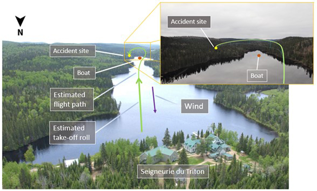
History of the flight
At approximately 0947Footnote 1 on the morning of 12 September 2021, the Piper J3C-65 floatplane (registration CF-SVT, serial number 14676) took off from the Batiscan River near La Seigneurie du Triton outfitter, 25 nautical miles (NM) east-northeast of La Tuque Aerodrome (CYLQ), Quebec, for a visual flight rules (VFR) flight to Saint-Étienne-des-Grès/Hydravion Adventure Water Aerodrome (CHA2), Quebec. On board were the pilot, who was sitting in the rear seat, and a passenger, who was sitting in the front seat. The plan was for the pilot to fly over the outfitter’s cottages after takeoff so that the passenger could take photos.
After a southbound takeoff, the floatplane flew near the surface of the water (in ground effectFootnote 2 ) to reach the target climb speed of 70 mph more quickly. At approximately 4300 feet from the point of departure, the floatplane, still in ground effect, banked right to avoid flying over a boat. Approximately 2000 feet further (i.e. approximately 6300 feet from the point of departure), it climbed slightly to approximately 100 feet above the river and began a 180° left turn toward rising terrain (Figure 1). During the left turn, at a 45° bank angle,Footnote 3 its speed and altitude decreased. The pilot lost control of the floatplane when it entered an aerodynamic stall, leading to an incipient spin. The floatplane struck trees, then terrain in a vertical attitude.
Individuals nearby went to the accident site. Emergency service assistance was requested. The pilot received serious injuries, and the passenger received fatal injuries. They were both wearing their lap belt. The aircraft was not equipped with shoulder harnesses, nor was it required to be by regulation. The aircraft was destroyed by impact forces. There was no post-impact fire .
Accident site and examination of the wreckage
The wreckage was found on the forest floor approximately 65 feet from the shoreline. Damage to the trees around the accident site reflected the aircraft’s vertical descent. The wings were partially detached from the fuselage: the right wing was bent backward and the left wing had collapsed to the ground. Damage to the wings and structure was caused by the force of the impact and the work done by the first responders.
Control cable continuity was established. The deformation of the fuselage structure and the shifting of objects within the aircraft are indicative of a major lateral force from right to left at the time of the collision with the ground. The fuel tank located at the front of the fuselage was damaged, and less than 25 L of aviation fuel (AVGAS) spilled from it.
Pilot information
The pilot held the appropriate licence and ratings for the occurrence flight in accordance with existing regulations. He held a commercial pilot licence – aeroplane and a Category 1 medical certificate, both of which were valid. He had the following ratings: single-engine, multi-engine, Group 1 instrument, and seaplane. At the time of the accident, he had accumulated approximately 1300 flight hours, including 790 on floatplanes and 78 on the occurrence floatplane. The pilot had flown to this outfitter once before, but he had never taken off southbound from this location on the Batiscan River.

Aircraft information
The occurrence Piper Cub J3C-65 was manufactured in 1945 (Figure 2). It had a valid certificate of airworthinessFootnote 4 (A691 – Normal) and was equipped with a Teledyne Continental 90-hp C-90-12F engine. It had accumulated 3862.5 flight hours since it was manufactured and had no known deficiencies before the occurrence flight.
The aircraft was equipped with EDO 60-1320 floats and had a maximum allowable take-off weight of 1300 pounds. The weight and balance calculation performed as part of this investigation determined that the aircraft’s take-off weight was 1367 pounds for the occurrence flight. Wing loadingFootnote 5 increases as the aircraft’s weight increases, which in turn increases the stall speed and reduces aircraft performance during a climb.
In this 2-seat aircraft model, the pilot normally sits in the rear seat (with or without a passenger). Therefore, with a passenger in the front seat, the pilot of the occurrence flight did not have a clear view of the airspeed indicator.Footnote 6 The aircraft was not equipped with a stall warning system, nor was it required to be by regulation.
The occurrence aircraft had an automatic fixed emergency locator transmitter (ELT) (manufactured by ACK Technologies Inc., model E-01) capable of broadcasting only on frequencies 121.5 MHz and 243 MHz. ELT signals on these frequencies can be detected by other aircraft and air traffic control (ATC) that monitor these frequencies. However, these frequencies are no longer monitored by the search and rescue satellite-aided (SARSAT) system at the Joint Rescue Coordination Centre / Canadian Mission Control Centre in Trenton, Ontario. In this occurrence, although the ELT and antenna had been working properly, no ELT signal was reported on 121.5 MHz or 243 MHz, by aircraft or by ATC.
Weather information
Weather conditions were favourable for this VFR flight, but a cold front was moving in from the west. VeeringFootnote 7 of the wind as a cold front passes causes a wind that is initially from the south to gradually shift to the southwest, and finally to the west after the front has passed. Information gathered during this investigation determined that the front was near the Batiscan River, but it was impossible to determine exactly when the front passed. However, strong winds from the south, estimated at approximately 15 knots at the time the occurrence floatplane took off, were reported by individuals nearby.
Characteristics of winds close to the surface
This section of the Batiscan River experiences sudden wind shifts (shear) due to the terrain, which results in difficult flying conditions. The terrain on both sides of the river is conducive to very-low-level airflow in a north-south direction at the surface of the water. However, in this occurrence, as the aircraft moved away from the surface and reached the peaks of the hills to the west, it is very likely that the wind changed strength and direction (veering from south to southwest) due to the proximity of the cold front. This shift in the wind may have caused a horizontal wind shear, turbulence, and downdrafts in the lee of the hills to the west.
Vertical wind shear, or wind gradient, causes a change in the wind speed near the ground, particularly below 100 feet. On the ground, obstacles and the roughness and unevenness of the surface significantly slow down the wind, while at altitude, in the undisturbed layers of the geostrophic wind, the surface no longer affects the wind. Between these 2 extremes, the wind speed varies depending on the altitude.Footnote 8
In the occurrence flight, the aircraft was flying over the river at low altitude, approximately 65 feet, when the left turn was initiated in the lee of the hills to the west of the river. The aircraft ended up above the trees to the east of the river. Therefore, it is possible that some of the factors related to the winds close to the surface were present and contributed to the reduction in the aircraft’s speed and performance.
Low-altitude turns
Flying at low altitude reduces the safety margin in the event of engine failure, loss of control, or other unforeseen circumstances, while increasing the risk of collision with the ground. Also, low-altitude turns cause optical illusions that may skew the perception of the aircraft’s speed and drift, and increase the risk of losing control during flight. Given the severity of the consequences of a loss of control at low altitude, low-altitude turns carry a high level of risk.
Optical illusions related to a significant change in ground speed
When an aircraft shifts from a headwind to a tailwind during a turn, its ground speed may increase significantly. Under these conditions, the ground moves by faster, and the pilot may overestimate the aircraft’s actual airspeed and reduce its speed enough to cause a stall. In addition, if an aircraft is climbing at a fixed rate in a turn but its ground speed doubles, its climb angle for clearing obstacles drops by approximately half.
Optical illusions related to flying close to terrain
When flying in mountainous areas or near hills where the terrain blocks the view of the actual horizon,Footnote 9 pilots may have more difficulty determining the aircraft’s exact attitude, altitude, and airspeed, particularly when the aircraft is below the highest point of the terrain.
In addition, when pilots see rising terrain ahead, they will be prompted to increase the aircraft’s nose-up attitude, which can lead to a decrease in airspeed. Furthermore, as the aircraft approaches the rising terrain, pilots feel more and more as though they are flying faster than they would feel flying at the same speed but at a higher altitude. Consequently, when pilots approach rising terrain, they may raise the nose of the aircraft to maintain a constant angle between the part of the aircraft that serves as a reference and the rising terrain. If pilots do not consult their instruments and rely solely on external visual cues, they will have more difficulty recognizing the effects that nosing up will have on the aircraft’s performance, given the additional illusions caused by the proximity of the rising terrain.Footnote 10
Optical illusions created by drift
Drift is the difference between an aircraft’s heading and its track over the ground. An aircraft’s drift while in a turn close to the ground in high winds gives the pilot the impression that the aircraft is changing speed, sliding inward, or skidding outward. During a left turn, the illusion created by the drift may cause a pilot to apply rudder on the inner side of the turn, thereby increasing the likelihood that the left wing will stall before the right wing, resulting in an incipient spin.
Optical illusion created when a turn is below the pivotal altitude
The pivotal altitude is the altitude at which, for a given ground speed, the extension of the lateral axis of the airplane appears to be fixed on a point on the ground from the pilot’s perspective.Footnote 11 At a ground speed of 50 mph, the pivotal altitude is 168 feet above ground level (AGL), while at 80 mph it is 429 feet AGL. When pilots turn left below the pivotal altitude, they may have the impression that the lower wing is moving faster than usual, which may cause them to apply rudder on the inner side of the turn, thereby increasing the likelihood that the left wing will stall before the right wing, resulting in an incipient spin.Footnote 12
In this occurrence, the low-altitude left turn began at an initial indicated airspeed of approximately 70 mph, when the wind was blowing at around 20 mph. The significant increase in ground speed from approximately 50 mph (headwind) to approximately 90 mph (tailwind), i.e. almost doubling, created a strong optical illusion and resulted in a reduction of almost 50% in the climb angle to eventually clear the terrain east of the river. Because the turn was conducted below the peak of the hills, it was more difficult to establish the aircraft’s attitude in relation to the actual horizon. During the turn, the aircraft was heading toward rising terrain, which may have caused the pilot to increase the aircraft’s nose-up attitude, resulting in a loss of speed.
The optical illusion created by the drift was strong because of the winds and the speed of the floatplane at the time of the turn at approximately 65 feet, which was below the pivotal altitude. These illusions, combined with a low speed, can create conditions that are favourable for a loss of control.
Aerodynamic stall
An aerodynamic stall is a loss of lift and an increase in drag that occurs when an aircraft is flying at an angle of attack greater than the angle that provides maximum lift. Regardless of airspeed, an aircraft always stalls when its wings reach this critical angle of attack.Footnote 13 Stall speed varies depending on factors such as weight, power, flap position, and angle of bank.
In a turn, the greater the angle of bank, the more lift is needed to maintain a constant altitude. With a 45° bank angle, approximately 30% more liftFootnote 14 is required to maintain the same altitude. This increase in lift results in greater drag and a drop in speed, which in turn increases the risk of a stall. Therefore, to maintain speed in a turn, power must be increased.
According to the occurrence aircraft’s flight manual, the stall speed was 38 mph in straight flight and 47.5 mph at an angle of 50°. These stall speeds had been calculated based on the maximum allowable take-off weight (1200 pounds) indicated for the J3C-65 aircraft in the 1st edition of the manual. When the floats were installed, the modifications necessary to increase the maximum weight by 100 pounds were made. Given that the take-off weight of the occurrence flight was 1367 pounds, the actual stall speeds were higher than those published.
Incipient spin
The video taken by the passenger on board the occurrence aircraft helped to determine that, during the left turn, the aircraft entered an incipient spin,Footnote 15 then struck the trees. This loss of control occurred during a low-altitude turn as the aircraft was flying from a headwind to a tailwind. Several compounding factors were present: high wing loading due to the aircraft’s weight and the 45° bank angle, strong low-level winds, and optical illusions created during the turn.
To offset most of these compounding factors, the airspeed indicator is a pilot’s main tool to detect a loss of performance (speed) and become aware of the various illusions at play. Given that the occurrence pilot was seated behind the passenger, the airspeed indicator was not directly in his line of sight. Without a stall warning system, the pilot could not have easily detected that a stall was imminent.
Safety message
Pilots must be aware that steep turns at low altitude pose a high risk due to reduced aircraft performance, increased stall speed, the characteristics of the winds close to the surface, and optical illusions that can skew speed and drift perception. These turns should normally be avoided, but if they are conducted, it is essential that pilots take these factors into consideration and closely monitor the indicated airspeed to avoid a loss of control.
This report concludes the Transportation Safety Board of Canada’s investigation into this occurrence. The Board authorized the release of this report on It was officially released on