Loss of control and collision with terrain
Privately registered
Cessna R182, C-FBKJ
Hope Aerodrome, British Columbia, 18 NM NE
The Transportation Safety Board of Canada (TSB) investigated this occurrence for the purpose of advancing transportation safety. It is not the function of the Board to assign fault or determine civil or criminal liability. This report is not created for use in the context of legal, disciplinary or other proceedings. See Ownership and use of content. Masculine pronouns and position titles may be used to signify all genders to comply with the Canadian Transportation Accident Investigation and Safety Board Act (S.C. 1989, c. 3).
History of the flight
At 1346Footnote 1 on 15 November 2021, the privately registered Cessna R182 aircraft (registration C-FBKJ, serial number R18200149) departed on a visual flight rules (VFR) flight plan from Nanaimo Airport (CYCD), British Columbia (BC), to Glacier Park International Airport (KGPI), Montana, United States. The filed flight plan showed a direct route from CYCD to KGPI, flown at an altitude of 10 500 feet above sea level (ASL). The pilot and 1 passenger were on board.
The aircraft flew southeast from CYCD, crossing into U.S. airspace above the San Juan Islands at approximately 4000 feet ASL. The aircraft continued to travel southeast, climbing to approximately 10 700 feet ASL before beginning a series of turns and descents, then ultimately backtracking toward the north at an approximate altitude of 3000 feet ASL. At 1435, when the aircraft was 16 nautical miles (NM) east of Skajit Regional Airport (KBVS), Washington, United States, it turned to the southeast again and began to climb, reaching an altitude of approximately 9900 feet ASL.
At 1444, the aircraft began a 90° turn to the southwest at an approximate altitude of 8400 feet ASL. Three minutes later, the aircraft made a sharp turn to the north and began a slow climb to approximately 10 000 feet ASL. At 1451, the aircraft changed its heading to the northeast; it was at an approximate altitude of 10 100 feet ASL at the time.
At 1458, when the aircraft was 4 NM southeast of Bacon Peak, Washington, it began a tight turn to the west. At this time, the aircraft was at approximately 11 500 feet ASL. The aircraft began a slow descent to approximately 10 100 feet ASL before turning north at 1504 and climbing again.
As the aircraft passed 4 NM east of the summit of Mount Baker, Washington, it was at an approximate altitude of 12 000 feet ASL with a ground speed of 120 knots. The aircraft then turned to the northeast and continued to climb to approximately 13 700 feet ASL before turning north and then northwest at 1523. The aircraft then turned west and began a slow descent.
At 1526, the aircraft began a sequence of climbs, descents and heading changes that lasted several minutes. The aircraft climbed as high as 12 300 feet ASL, travelling southwest, before descending to approximately 9300 feet ASL and recovering on a northeast heading.
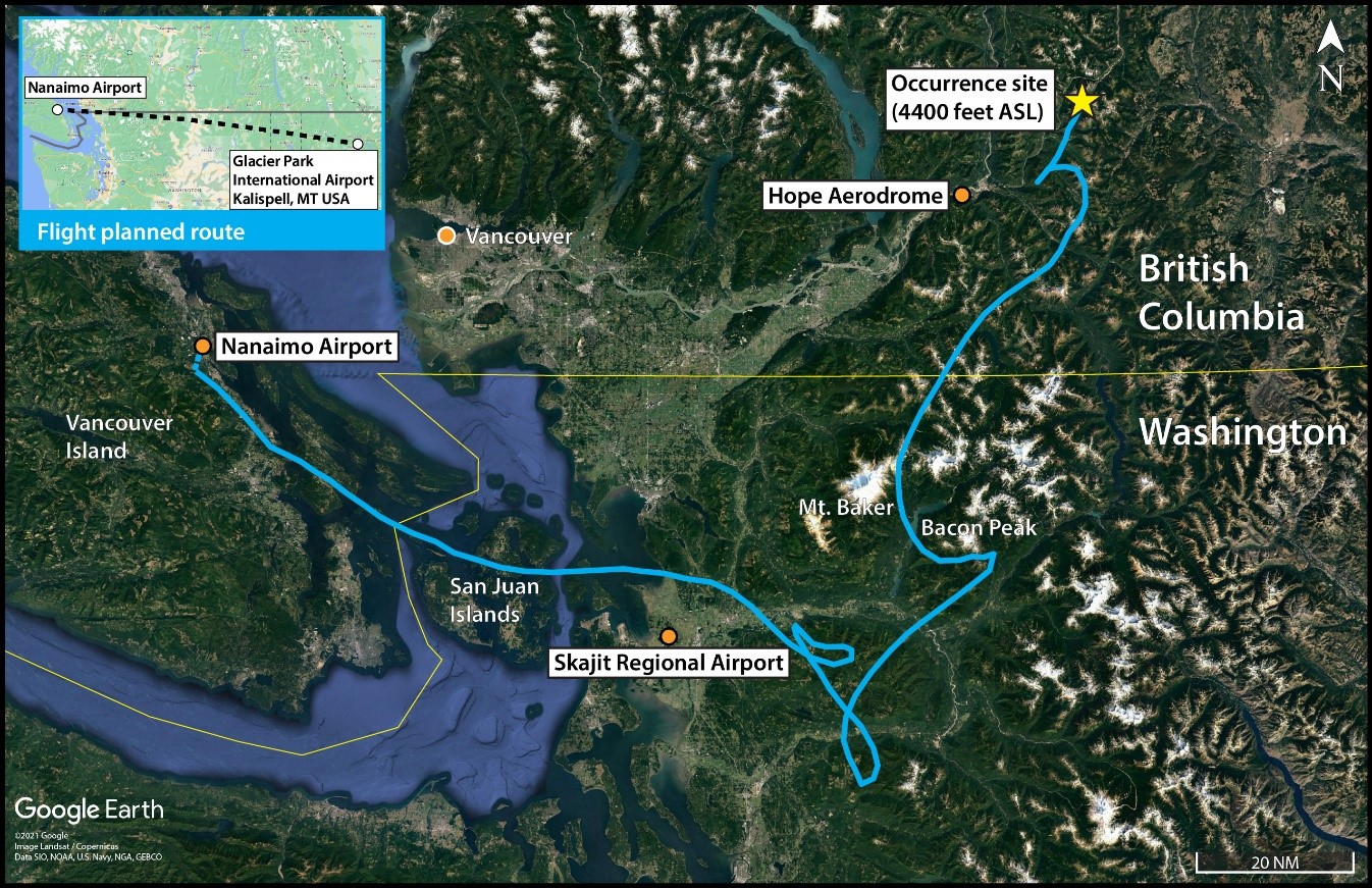
The aircraft began to climb as it travelled northeast, reaching approximately 12 100 feet ASL. During this time, the aircraft’s ground speed gradually decreased from approximately 150 knots to 40 knots. The aircraft had been travelling above 10 000 feet ASL for 47 minutesFootnote 2 when it a entered descending spiral pattern from which it did not recover. The last recorded radar target was at 1541, at which time the aircraft was at an altitude of approximately 8700 feet ASL heading toward Needle Peak, BC (Figure 1).
The Canadian Mission Control Centre in Trenton, Ontario, received an emergency locator transmitter signal from the aircraft. The Joint Rescue Coordination Centre in Victoria, BC, initiated an aerial search; however, low clouds, poor visibility, and aircraft icing in the area hampered the search effort. A ground search was not possible due to road closures caused by flooding in the area.
At approximately 0140 on 16 November 2021, the crash site was discovered 18 NM northeast of Hope Aerodrome (CYHE), BC, near Needle Peak at an elevation of approximately 4400 feet ASL. Both of the aircraft's occupants were fatally injured. The aircraft was destroyed on impact; there was no post-impact fire.
Previous flight
The investigation examined a previous flight conducted by the occurrence pilot in the same aircraft and with the same passenger on board. On 13 November 2021, the aircraft departed on a VFR flight plan from Lloydminster Airport (CYLL), Alberta, to CYCD. The flight included a planned fuel stop at Salmon Arm Airport (CZAM), BC.
While travelling between CYLL and CZAM, the aircraft was flown above 10 000 feet ASL continuously for approximately 1 hour and 34 minutes, reaching a maximum altitude of approximately 20 100 feet ASL.
Hypoxia
Flying unpressurized aircraft at high altitudes without the use of oxygen can lead to hypoxia.Footnote 3
Section 605.31 of the Canadian Aviation Regulations (CARs) stipulates that, for unpressurized aircraft such as the occurrence aircraft, a supply of oxygen must be available for the flight crew and at least 1 passenger for flights exceeding 30 minutes at cabin-pressure altitudes above 10 000 feet ASL but not exceeding 13 000 feet ASL. When the aircraft is operating at cabin-pressure altitudes above 13 000 feet ASL, a supply of oxygen must be available for all persons on board the aircraft.Footnote 4
In addition, section 605.32 of the CARs states the following regarding the use of oxygen:
(1) Where an aircraft is operated at cabin-pressure-altitudes above 10,000 feet ASL but not exceeding 13,000 feet ASL, each crew member shall wear an oxygen mask and use supplemental oxygen for any part of the flight at those altitudes that is more than 30 minutes in duration.
(2) Where an aircraft is operated at cabin-pressure-altitudes above 13,000 feet ASL, each person on board the aircraft shall wear an oxygen mask and use supplemental oxygen for the duration of the flight at those altitudes.Footnote 5
Pilot information
The pilot held a private pilot licence and his Category 3 medical certificate was valid. His licence had been issued in September 2021. The pilot had accumulated approximately 116 hours total flying time, approximately 55 hours of which were completed as pilot-in-command. Of the total time, approximately 42 hours were completed in the occurrence aircraft.
In addition to his private pilot licence training, the pilot had completed a 3.7 hour recreational mountain flying course in September 2021. The pilot did not hold an instrument rating.
Aircraft information
The occurrence aircraft was a Cessna R182 manufactured by the Cessna Aircraft Corporation in 1978. It was equipped with a 235-hp Avco Lycoming O-540-J3C5D engine. The aircraft was not equipped for flight in instrument meteorological conditions or in known icing conditions, and there was no supplemental oxygen system on board. The aircraft was not equipped with a flight data recorder or a cockpit voice recorder, nor was it required to be by regulation.
The aircraft’s last annual inspection was completed on 01 September 2021. At the time of the occurrence, the aircraft had accumulated approximately 8575 hours of total air time. The last entry in the aircraft journey logbook recovered from the site was completed on 30 October 2021. At least 2 flights had been completed since that entry, but they had not been recorded.
Records indicate that there were no outstanding defects at the time of the occurrence. There was no indication that a component or system malfunction played a role in this occurrence.
Wreckage and impact information
The aircraft was found upside down on a forested 39° slope (Figure 2). Damage to the aircraft was consistent with the aircraft striking trees in a steep nose-down attitude. Both wings and the engine had come off the main fuselage. The aircraft collided with the ground approximately 40 feet from where it first struck the trees. This impact is consistent with a loss of control of the aircraft.
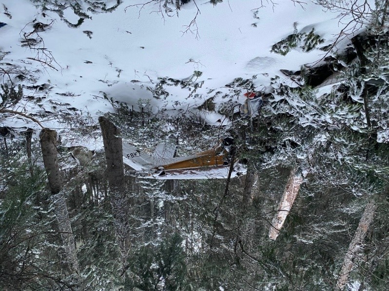
The investigation determined there were no signs of pre-impact mechanical failure or system malfunction. The damage to the engine and propeller indicates that power was being produced during the impact sequence. There was no indication of fire in the wreckage.
Weather information
The investigation was unable to determine what weather information the pilot checked before departure. A VFR flight plan was filed electronically; however, there was no record that the pilot had received a weather briefing from NAV CANADA.
The aerodrome forecast (TAF), issued at 0941, indicated that conditions at CYCD at 1300 would be:
- Winds from 340° true (T) at 10 knots, gusting to 20 knots
- Visibility more than 6 statute miles (SM)
- Scattered cloud at 2500 feet above ground level (AGL) and broken ceiling at 4000 feet AGL
Temporarily until 1800 on the day of the occurrence, the TAF indicated:
- Visibility of 4 SM in light rain showers and mist
- Broken ceiling at 2000 feet AGL
The TAF for KGPI, issued at 1233, indicated the following conditions until 1600:
- Winds from 200°T at 10 knots
- Visibility more than 6 SM
- Broken ceiling at 25 000 feet AGL
The graphic area forecasts (GFA) issued at 0951, valid from 1000 in the occurrence area, indicated:
- A cold front aloft moving northeast through the area
- Overcast cloud layers with bases between 2000 and 4000 feet ASL and tops at 20 000 feet ASL
- Visibility expected to be from 2 SM to more than 6 SM in rain or light rain and mist
- Extensive ceilings between 500 and 1500 feet AGL
- Isolated altocumulus castellanus clouds with tops at 24 000 feet ASL with visibility of ¾ SM in rain showers and mist
The freezing level was forecast to be between 5000 and 7500 feet ASL with moderate mixed icing from the freezing level up to 20 000 feet ASL. Lee waves and/or mechanical turbulence was expected to be moderate with local areas of severe turbulence.
According to the upper winds forecast for the area that was valid at the time of the occurrence, for the altitudes between 9000 and 12 000 feet ASL, the winds were forecast to be from 270°T at 37 knots, increasing steadily to 38 knots, with temperatures decreasing from −13 °C to −20 °C.
The closest aviation weather reporting station to the occurrence site is located at CYHE, 18 NM to the southwest. The automated weather observation system at CYHE recorded the following information at 1416, 84 minutes before radar contact with the aircraft was lost:
- Winds from 300°T (varying between 250°T and 340°T) at 17 knots, gusting to 30 knots
- Visibility 3 SM in rain and mist
- Temperature 7 °C, dew point 5 °C
- Altimeter setting 29.39 inches of mercury (inHg)
- 0.8 mm of rain in the last hour
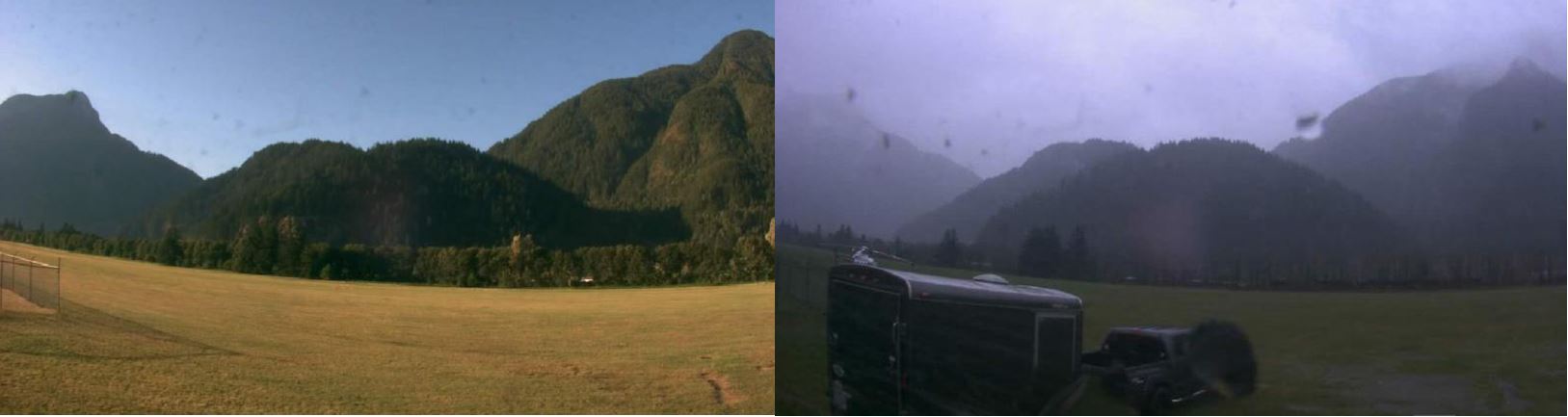
NAV CANADA operates automated weather cameras at CYHE. Figure 3 shows the southeast view taken by the cameras on both a clear day and on the day of the occurrence.
The Princeton Aerodrome (CYDC), BC, is 25 NM to the east of the occurrence site. Weather at the aerodrome was recorded at 1600 as:
- Winds from 260° T (varying between 220° T and 300° T) at 17 knots, gusting to 25 knots
- Visibility 10 SM in light rain showers
- Few clouds at 800 feet AGL, few clouds at 2600 feet AGL, scattered clouds at 3700 feet AGL, a broken ceiling at 4300 feet AGL including cumulonimbus clouds, and broken clouds at 8800 feet AGL
- Temperature 6 °C, dew point 2 °C
- Altimeter setting 29.39 inHg
Terrain along the route
On the day of the occurrence, the aircraft passed over the Puget Sound region of Washington State. This area is a relatively low-lying coastal area characterized by an array of bays, islands, and peninsulas.
Travelling east, the aircraft quickly encountered the Cascade Mountain Range, which extends from Northern California to Southern BC. This mountain range is rugged and has numerous high peaks; many of those in the north Cascade area are over 9000 feet. Mount Baker is the highest peak in the vicinity of the occurrence flight at 10 786 feet (3286 m).
On the day of the occurrence, many of the mountain peaks along the route were above the cloud layers and would have been obscured to the pilot.
TSB laboratory reports
The TSB completed the following laboratory report in support of this investigation:
- LP171/2021 – Radar data analysis
Safety messages
In this occurrence, the aircraft was flying in an area of forecast icing and instrument meteorological conditions at altitudes requiring the use of supplemental oxygen; however, the pilot did not hold an instrument rating, the aircraft was not equipped for flight in known icing conditions, and no supplemental oxygen system was on board.
TSB investigations continue to demonstrate that VFR flights into instrument meteorological conditions often result in a fatal collision with terrain or loss of control due to lost visual references.
It is important that pilots assess all available weather information before departure, plan routes to avoid weather hazards, and anticipate using alternate routes should unexpected weather be encountered.
Furthermore, pilots must operate within the limitations of their aircraft, the privileges of their licence, and their own experience-based limits.
This report concludes the Transportation Safety Board of Canada’s investigation into this occurrence. The Board authorized the release of this report on . It was officially released on .