Collision with Terrain During Take-off
Portland Creek Aviation Limited
de Havilland DHC-2 Beaver C-GBZS
Bryants Raft Pond, Newfoundland and Labrador
The Transportation Safety Board of Canada (TSB) investigated this occurrence for the purpose of advancing transportation safety. It is not the function of the Board to assign fault or determine civil or criminal liability. This report is not created for use in the context of legal, disciplinary or other proceedings. See Ownership and use of content. Masculine pronouns and position titles may be used to signify all genders to comply with the Canadian Transportation Accident Investigation and Safety Board Act (S.C. 1989, c. 3).
Summary
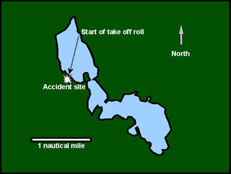
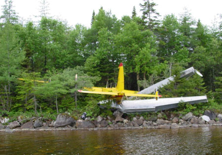
The single-engine, float-equipped de Havilland DHC-2 Beaver aircraft (registration C-GBZS, serial number 1595) was taking off from Bryants Raft Pond, Newfoundland and Labrador, to fly to Charlottetown, Newfoundland and Labrador. There were four passengers and the pilot on board. During the take-off run, the aircraft did not get airborne, and the pilot aborted the take-off and shut down the engine. The aircraft struck the rocky shoreline at approximately 30 mph, the floats were torn off, and the aircraft continued for about 20 feet into spruce trees and underbrush. The aircraft came to rest with the forward fuselage and engine cowling dug into the forest floor. The aircraft was substantially damaged, but there was no post-crash fire. The five occupants evacuated the aircraft uninjured, and walked a short distance to a road where they met police officers, who had been alerted to the accident. The accident occurred at approximately 1100 Newfoundland daylight time.
Factual information
Before the flight, the pilot ensured that there was no water in the floats. The pilot started and taxied the aircraft for approximately 10 minutes in order to check the aircraft and warm up the engine. The surface wind was approximately 10 knots from a direction across the pond; the pilot elected to conduct the take-off into the wind. The pilot had the option of taking off down the pond with a crosswind, which was a longer distance. The distance across the pond, from shoreline to shoreline, was approximately 2900 feet. The available distance for take-off was somewhat less because the aircraft could not taxi in the shallow water along the shoreline, and there were obstacles on the departure path.
The pilot used the checklist to configure the aircraft for take off. The wing flaps were in the take-off position and aircraft power plant was noted to be developing maximum power as the take-off run began. The aircraft accelerated to 50 mph at which time the pilot expected the aircraft to be breaking the surface of the water. The aircraft did not perform as expected, and continued to accelerate on the water. The pilot attempted a manoeuvre that involved rolling the aircraft slightly, from side to side, so that one float would break the surface of the water, thereby reducing the water drag imposed on the floats. The manoeuvre was not successful and the pilot returned the aircraft to a level attitude with both floats in the water. At this time, the aircraft appeared to be close to take off; however, the pilot aborted the take-off because the aircraft may not have cleared the trees in the distance. The pilot closed the throttle, shut down the engine, and called to the occupants to brace for impact. When the aircraft stopped, the pilot confirmed that the occupants were not injured, and ordered an evacuation.
There is no weather observation station at Bryants Raft Pond. The closest stations are as follows: Daniel's Harbour, an automated weather observation station (AWOS), is located approximately 30 nautical miles (nm) southwest, St. Anthony (YAY), about 65 nm northeast, and Deer Lake (YDF), about 85 nm south.
The weather at Daniel's Harbour at the approximate time of the accident was as follows: visual flight rules (VFR) conditions, temperature 14°C, wind 220° magnetic (M) at 8 knots, altimeter 29.94 inches of mercury (in. Hg).
The weather at YAY at 1030 Newfoundland daylight timeFootnote 1 was as follows: VFR conditions, temperature 15°C, wind 270°true (T) at 4 knots, altimeter 29.98 in. Hg. The 1130 weather was as follows: VFR conditions, temperature 16.4°C, wind 260° at 10 knots, altimeter 29.97 in. Hg.
The weather at YDF at 1030 was as follows: VFR conditions, temperature 18°C, wind 210°T at 6 knots. The 1130 weather was as follows: VFR conditions, temperature 19°C, wind 210°T at 10 knots.
Weather conditions at the Bryants Raft Pond at the time of the accident were estimated as sky mostly clear with the wind not more than 10 knots from the southeast. Bryants Raft Pond is about halfway between YAY and YDF and both Bryants Raft Pond and YDF are inland. As YAY and the Daniel's Harbour AWOS are located close to the ocean, it would be reasonable to assume that the temperature at Bryants Raft Pond would be similar to that of YDF, about 19°C.
The pilot held a valid commercial pilot licence issued by Transport Canada, which was endorsed for single-engine landplanes and seaplanes. He had accumulated approximately 6000 hours of total flying experience, of which about 3600 hours were on the DHC-2 Beaver. In the previous 90 days, the pilot had flown 20 hours. He had been employed with the operator for approximately three years. He was adequately rested before the accident flight.
The passengers included the owner/operator of the aircraft, a pilot observer, and two persons going to Charlottetown for recreational fishing. The owner was on board to lend assistance and the pilot observer, who was an employee of the operator, was on board for orientation as he would be receiving a check-out on this aircraft in the near future. The owner had a total of 6000 hours of flying experience with approximately 3500 hours on this aircraft type on floats and skis. Neither the pilot nor the pilot observer could identify why the aircraft did not perform as expected and failed to get airborne.
The aircraft was manufactured in 1965, and had accumulated approximately 6703.4 hours of total time on the airframe. The aircraft had been flown approximately 15 hours since the last inspection, and there were no reported mechanical problems immediately before or during the accident flight. There was approximately 65 Imperial gallons of fuel on board the aircraft; enough for approximately three hours of flying. According to the completed weight and balance form, the aircraft weight at take-off was 4945 pounds. The maximum allowable take-off weight for this aircraft is 5090 pounds. The centre of gravity was within the prescribed limits, but in the forward part of the acceptable range.
Based on the aircraft's weight at the time of the take-off, a temperature of 15°C, and no wind, the calculated take-off distance was 1540 feet; at a temperature of 30°C, the take-off distance was increased to 1675 feet. With a 10 mph headwind, the take-off distances would decrease to about 1180 and 1300 feet respectively.
The shoreline of Bryants Raft Pond in the direction of take-off consisted of a rocky bank approximately three feet above the water level after which there was soft, level forest floor with spruce trees and undergrowth. Beyond this, there was a low hill.
Wreckage examination revealed that the aircraft was substantially damaged. The propeller was bent, the lower, forward fuselage was damaged, the leading edge of both wings were damaged from tree impact, the right wing was bent forward from its normal position, and the floats and related support struts came to rest under the aircraft. The aircraft was removed from the site several days after the accident. Further inspection revealed that the rear attachment point for the left wing was damaged. The flaps were found in the take-off position, and the flap indicator showed the flaps at the take-off position. The carburetor heat selector was in the full cold position.
Analysis
Nothing was found that would explain the aircraft's lack of performance during the take-off run. The aircraft was not overweight, there was a light headwind, the engine was performing as expected, and the flaps were set at the take-off setting. The required take-off distance of 1540 feet was certainly well within the available length of 2900 feet, even if the take-off run was started a couple of hundred feet from the shore. It is possible that the floats contained some water, which would increase the aircraft's weight, or there was weight on the aircraft that had not been accounted for. It is also possible that water in the forward float compartments may have added to a nose-heavy centre of gravity, making it more difficult to become airborne.
The surface wind was estimated at 10 knots from the direction of take-off. The surface wind would have been blowing over a low hill and might have caused a slight downdraft, which could have decreased the aircraft's take-off performance.
Finding as to Causes and Contributing Factors
- The aircraft failed to get airborne for undetermined reasons.
This report concludes the Transportation Safety Board's investigation into this occurrence. Consequently, the Board authorized the release of this report on .

